The Canada Run Vista hike at Tioga State Forest near Wellsboro, Pennsylvania is an easy 2.2-mile out-and-back trail that leads to a seasonal vista at a clear-cut and includes views into Wellsboro, PA of Oak Point mountain, Round Top mountain, Mount Nessmuk, parts of Mount Tom, PA-362, and the Wellsboro Airport while perched above Canada Run creek.
Hike Description
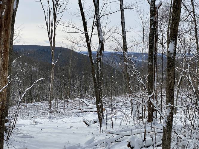
This hike begins at the yellow service gate along Baldwin Run Rd and follows an unnamed service road south as it winds its way through a hardwood forest.
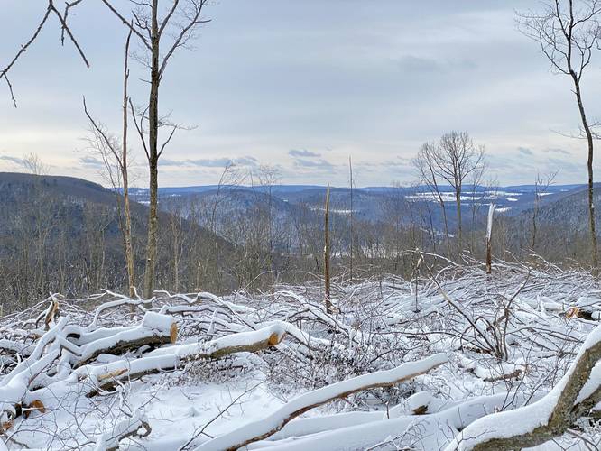
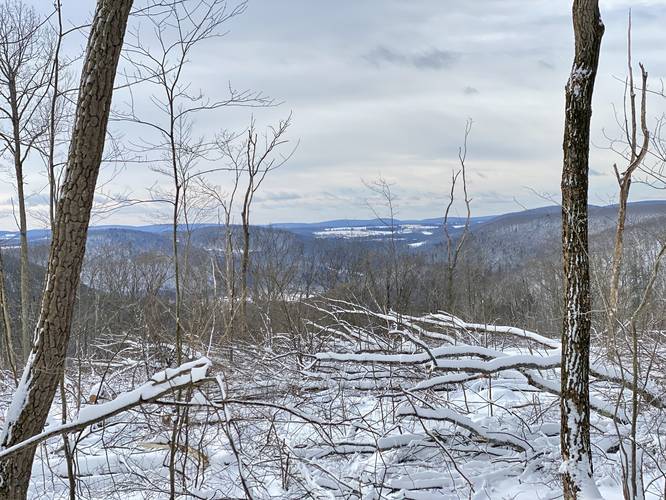
The trail slowly makes its way down the mountain and over to a steeper mountain ridge where the logger began clearing trees in March 2022. There's one left-hand turn that leads down to a more obstructed-vista clear cut, so the better view is located by staying to the right-hand side of the trail. The best vista is located around mile 1.1 (assuming you hike down to the left-hand turn first). Here, hikers get a seasonal and slightly-obstructed view facing south. From left-to-right, the view includes: the downward slope of Oak Point mountain, Round Top mountain (private land), in the background is PA-362 and the Wellsboro Airport, the top of Mount Tom, and finally Mount Nessmuk's downward slopes on the right-hand side.
Logging History (2022)
As of March 2022, when I mapped this trail, there was a solo logger hired to cut a 100-acre clear-cut here and he started at the mountain edge earlier that month. Since I can see this mountain from my house, I decided to investigate. Upon both trips, I ran into the logger (see the photos of his tractor), when I learned that this logging effort was planned to be a 100-acre clear-cut and would be completed by the end of Autumn 2022, so there will likely be more / better views in the future.
Pets
Dogs are allowed if leashed and their waste should be carried out by the hiker.
Parking
Hikers will find parking near the service road gate. As of March 2022, there's a gas well located next to the service road gate. If you feel uncomfortable leaving your car directly next to a gas well (for various reasons), you can likely find a spot to pull off of Baldwin Run Rd as well. Please note that this road is used for trucking activities for these fracking sites - do not block the road in any way.
Camping and Backpacking
While camping is allowed here, there were no pre-defined campsites. Please follow all rules and regulations when dispersed / backcountry / primitive camping. Also note that it's likely not smart to camp in this area until after the logging has been completed, after Autumn 2022.
Hike Description
This hike begins at the yellow service gate along Baldwin Run Rd and follows an unnamed service road south as it winds its way through a hardwood forest.
The trail slowly makes its way down the mountain and over to a steeper mountain ridge where the logger began clearing trees in March 2022. There's one left-hand turn that leads down to a more obstructed-vista clear cut, so the better view is located by staying to the right-hand side of the trail. The best vista is located around mile 1.1 (assuming you hike down to the left-hand turn first). Here, hikers get a seasonal and slightly-obstructed view facing south. From left-to-right, the view includes: the downward slope of Oak Point mountain, Round Top mountain (private land), in the background is PA-362 and the Wellsboro Airport, the top of Mount Tom, and finally Mount Nessmuk's downward slopes on the right-hand side.
Logging History (2022)
As of March 2022, when I mapped this trail, there was a solo logger hired to cut a 100-acre clear-cut here and he started at the mountain edge earlier that month. Since I can see this mountain from my house, I decided to investigate. Upon both trips, I ran into the logger (see the photos of his tractor), when I learned that this logging effort was planned to be a 100-acre clear-cut and would be completed by the end of Autumn 2022, so there will likely be more / better views in the future.
Pets
Dogs are allowed if leashed and their waste should be carried out by the hiker.
Parking
Hikers will find parking near the service road gate. As of March 2022, there's a gas well located next to the service road gate. If you feel uncomfortable leaving your car directly next to a gas well (for various reasons), you can likely find a spot to pull off of Baldwin Run Rd as well. Please note that this road is used for trucking activities for these fracking sites - do not block the road in any way.
Camping and Backpacking
While camping is allowed here, there were no pre-defined campsites. Please follow all rules and regulations when dispersed / backcountry / primitive camping. Also note that it's likely not smart to camp in this area until after the logging has been completed, after Autumn 2022.