The Soda Canyon Overlook Trail at Mesa Verde National Park, Colorado is an easy 1.3-mile out-and-back hike that features three overlooks of Soda Canyon and includes one overlook that peers into the ancient Puebloan dwelling complex known as the Balcony House.
Hike
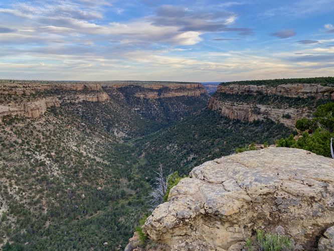
The Soda Canyon Overlook Trail is the only trail at the park that provides visitors with unobstructed views of the ancient Puebloan cliff dwellings known as the Balcony House. For this reason, hikers should seriously consider hiking this trail as the Balcony House is one of the most-impressive cliff dwellings found at the park -- next to the Cliff Palace and Square Tower House dwellings.
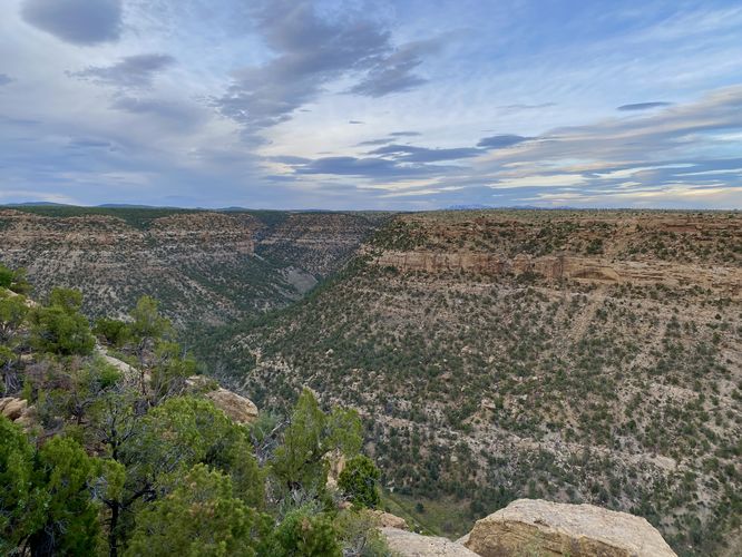
The trail begins along the northeastern section of the Cliff Palace Loop Road where hikers will find a well-defined trailhead. The majority of the hike passes through low-growing trees and shrubs that comprise Mesa Verde's landscape -- with old-growth juniper trees that grow alongside the trail. The path undulates its way, with an "easy" difficulty-level, out to three overlooks that reside at the rim of Soda Canyon. This route follows the loop near the end of the trail in a counter-clockwise direction, which arguably hits the best views first.
Balcony House Overlook - Mile 0.6
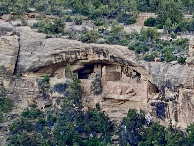
Around mile 0.6, after keeping-right at the loop and right at the first overlook, hikers will reach the Balcony House Overlook. From here, you'll find sweeping south-facing views into Soda Canyon and beyond, but the main attraction of this overlook is the ancient Puebloan cliff dwelling, Balcony House. Balcony House sits in a cliff alcove up high from the canyon's valley with multi-story houses built into the cliff. These dwellings were built circa 1200 CE. At the trail (and in the attached photos) is an interpretive sign that helps visitors understand the intense labor that went into building these cliff dwellings, including information on hand-hewed foot and hand-holds in the rock that were used for climbing up and down from the dwellings. The ancient people also used ladders to access certain parts of the complex and today, a paid and scheduled tour follows a similar-sized ladder that may have existed in the past. This ladder is visible from hundreds of feet away, across Soda Canyon, which shows just how high-up these dwellings sit as the ladder that stands today, for tours, appears to be approximately 50-feet tall from far away (an estimate).
2nd (Middle) Soda Canyon Overlook - Mile 0.65
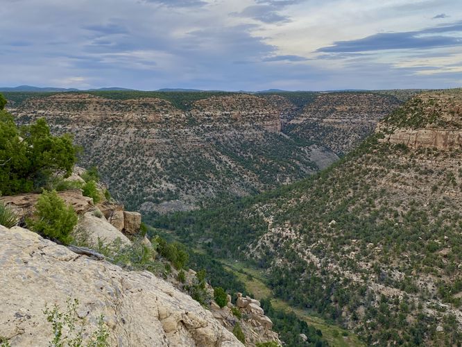
Just north from the Balcony House Overlook sits the "middle" overlook along this hike. Along the way there, you might notice the burnt and chard trees and timber that were once caught in a wildfire. Here, you can get both north and south-facing views of Soda Canyon. You can also spot cliff alcoves that appear to not have any ancient dwellings inside, but it's fun to look for them regardless.
North Overlook - Mile 0.7
The trail then leads northward to reach the final (3rd) overlook at Soda Canyon. Here, the views are mostly north into the canyon and resemble similar views that the 2nd (middle) overlook has to offer.
After exploring all three overlooks of Soda Canyon, the loop leads back to the main out-and-back pathway. Hikers will take the trail back to parking to complete this ~1.3-mile loop hike.
Parking
Visitors will find a parking lot at the coordinates provided along Cliff Palace Loop Road in the park. As of June 2024, the lot is large enough to fit approximately a dozen vehicles.
Pets
Dogs are not allowed on this trail. Dogs are allowed on paved trails including the Park Point Trail and the Mesa Top Loop Sites including: The Navajo Canyon Overlook, Square Tower House Overlook Trail, Pithouses & Pueblos Loop, Mesa Top Sites Trail, Sun Point Pueblo, Sun Point View, Oak Tree House View, Fire Temple & New Fire House View, and the Sun Temple & Cliff Palace View.
Warning
Steep cliffs: This trail leads out to tall and steep cliffs.
Sun exposure: Due to the lack of trees and shade, this trail has a high exposure to the sun and weather. Plan to bring sunscreen to protect yourself against high UVs.
Rattlesnakes: Mesa Verde is home to rattlesnakes that might be out basking in the sun during warm months. While encounters are rare, give any rattlers you find plenty of space.
Hike
The Soda Canyon Overlook Trail is the only trail at the park that provides visitors with unobstructed views of the ancient Puebloan cliff dwellings known as the Balcony House. For this reason, hikers should seriously consider hiking this trail as the Balcony House is one of the most-impressive cliff dwellings found at the park -- next to the Cliff Palace and Square Tower House dwellings.
The trail begins along the northeastern section of the Cliff Palace Loop Road where hikers will find a well-defined trailhead. The majority of the hike passes through low-growing trees and shrubs that comprise Mesa Verde's landscape -- with old-growth juniper trees that grow alongside the trail. The path undulates its way, with an "easy" difficulty-level, out to three overlooks that reside at the rim of Soda Canyon. This route follows the loop near the end of the trail in a counter-clockwise direction, which arguably hits the best views first.
Balcony House Overlook - Mile 0.6
Around mile 0.6, after keeping-right at the loop and right at the first overlook, hikers will reach the Balcony House Overlook. From here, you'll find sweeping south-facing views into Soda Canyon and beyond, but the main attraction of this overlook is the ancient Puebloan cliff dwelling, Balcony House. Balcony House sits in a cliff alcove up high from the canyon's valley with multi-story houses built into the cliff. These dwellings were built circa 1200 CE. At the trail (and in the attached photos) is an interpretive sign that helps visitors understand the intense labor that went into building these cliff dwellings, including information on hand-hewed foot and hand-holds in the rock that were used for climbing up and down from the dwellings. The ancient people also used ladders to access certain parts of the complex and today, a paid and scheduled tour follows a similar-sized ladder that may have existed in the past. This ladder is visible from hundreds of feet away, across Soda Canyon, which shows just how high-up these dwellings sit as the ladder that stands today, for tours, appears to be approximately 50-feet tall from far away (an estimate).
2nd (Middle) Soda Canyon Overlook - Mile 0.65
Just north from the Balcony House Overlook sits the "middle" overlook along this hike. Along the way there, you might notice the burnt and chard trees and timber that were once caught in a wildfire. Here, you can get both north and south-facing views of Soda Canyon. You can also spot cliff alcoves that appear to not have any ancient dwellings inside, but it's fun to look for them regardless.
North Overlook - Mile 0.7
The trail then leads northward to reach the final (3rd) overlook at Soda Canyon. Here, the views are mostly north into the canyon and resemble similar views that the 2nd (middle) overlook has to offer.
After exploring all three overlooks of Soda Canyon, the loop leads back to the main out-and-back pathway. Hikers will take the trail back to parking to complete this ~1.3-mile loop hike.
Parking
Visitors will find a parking lot at the coordinates provided along Cliff Palace Loop Road in the park. As of June 2024, the lot is large enough to fit approximately a dozen vehicles.
Pets
Dogs are not allowed on this trail. Dogs are allowed on paved trails including the Park Point Trail and the Mesa Top Loop Sites including: The Navajo Canyon Overlook, Square Tower House Overlook Trail, Pithouses & Pueblos Loop, Mesa Top Sites Trail, Sun Point Pueblo, Sun Point View, Oak Tree House View, Fire Temple & New Fire House View, and the Sun Temple & Cliff Palace View.
Warning
Steep cliffs: This trail leads out to tall and steep cliffs.
Sun exposure: Due to the lack of trees and shade, this trail has a high exposure to the sun and weather. Plan to bring sunscreen to protect yourself against high UVs.
Rattlesnakes: Mesa Verde is home to rattlesnakes that might be out basking in the sun during warm months. While encounters are rare, give any rattlers you find plenty of space.