Sand Run Falls Hike at Tioga State Forest in Wellsboro, Pennsylvania is an easy 3.5-mile out-and-back trail that leads to the base of the popular waterfall, Sand Run Falls. Please note that this is by far the easiest, shortest, and safest route to the base of Sand Run Falls, but the off-street parking area is very small (room for about two cars) which leaves limited options for hikers if planning to hike this trail on a weekend. The official Sand Run Falls Trail should be used instead during months of low rainfall when the creek is drier, as the parking lot for that trail is the official parking lot that can hold a dozen cars or more.
Regardless, this trail is considered easy since it's very flat leading most of the way to Sand Run Falls. Hikers should be aware of the dangers leading down to the waterfall, so please read the warnings before heading out and expect a steep downhill climb next to the waterfall.
Along the trail hikers will find wild ramps during the spring, along with plenty of mud during the first half of the hike. The best time to visit Sand Run Falls is after a heavy rain, which means this trail will likely be wet and muddy unless you visit during the dry Summer.
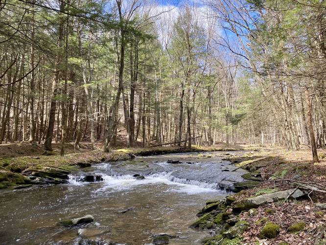
The trail is easy to follow and about half-way through, there will be a small but wide waterfall along the creek adjacent to this trail (shown in the map) and next to it is a 10-foot tall rock ledge that arches over the creek.
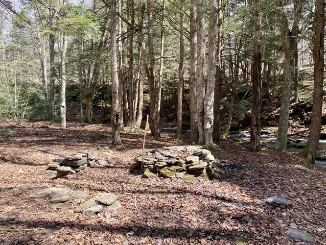
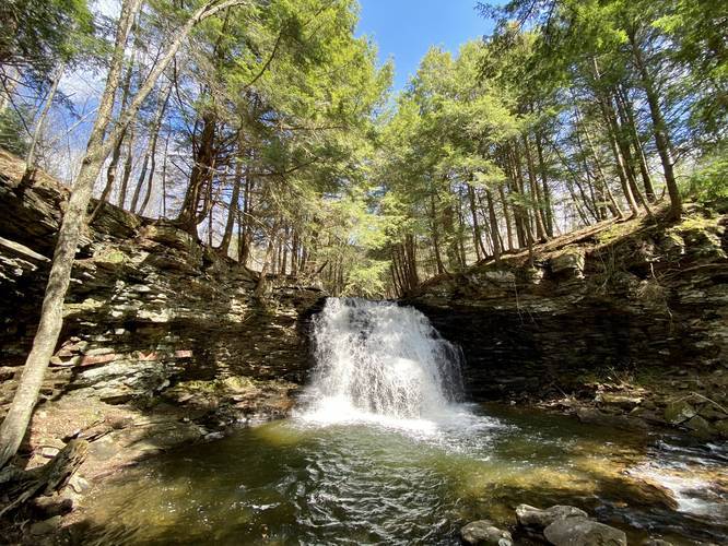
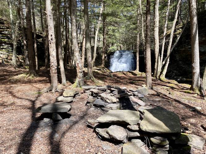
As you approach the top of Sand Run Falls, there will be a campsite to your left. Hike just a bit further to find the top of Sand Run Falls and eventually over to the ropes that lead down to the base of the waterfall. Use the ropes cautiously to head downhill to the base of Sand Run Falls. At the base of the waterfall, hikers will find beautiful views of Sand Run Falls itself along with an amazing campsite.
From here, the hike is finished unless you wish to view extra waterfalls along the Sand Run Falls Trail - only if you can manage to cross Sand Run Creek to make it to the other side. Please note that these other, smaller waterfalls, are not far away from Sand Run Falls at all, but they may be difficult to get to if you cannot cross Sand Run Creek. Please study the Sand Run Falls Trail map before planning to locate the additional waterfalls here.
Must-Read Note
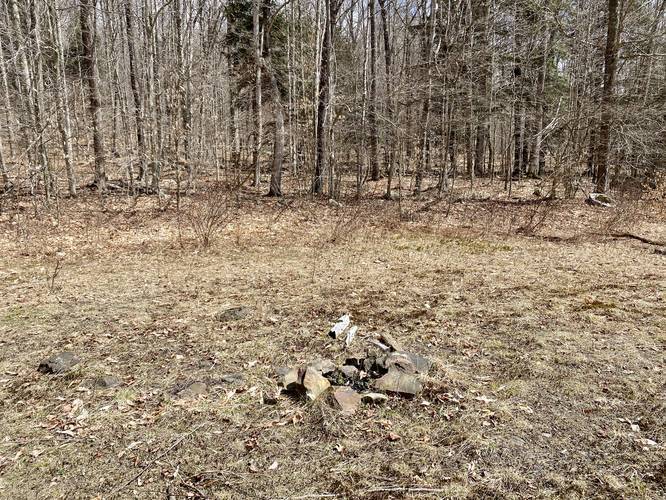
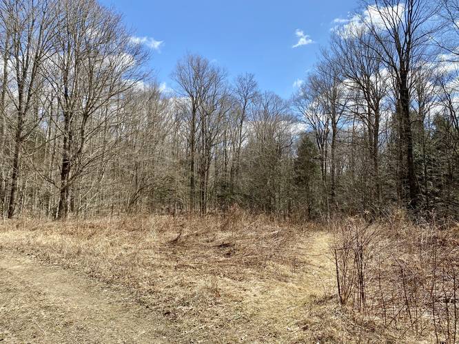
Shortly after hiking down the hill from the parking area, there will be an open field along the trail with a small campsite. Just beyond this campsite, the main service road turns and continues along a wide trail -- this wide service road is not the trail you must follow. The trail you must follow is located near the turn in this service road near the back of the field -- hike down the skinny trail that heads immediately downhill and then continue hiking along the orange blazed trail to find you way to Sand Run Falls.
Danger
Steep terrain: Reaching the base of Sand Run Falls follows a very steep hillside full of rocks and roots that's about 30-feet tall. Along this hillside is a set of ropes that helps hikers climb down to the base of the waterfall and the campsite below. This section of the trail may not be suited for all hikers, but there's still a nice vista of Sand Run Falls from the trail before the descent to the base of the waterfall. Hike at your own risk.
Rattlesnakes: While rare, the Timber Rattlesnake lives in this area and tends to come down to creeks to cool down or hunt between the end of April through the end of September. Watch your step and give any rattlesnake you see some space.
Camping and Backpacking
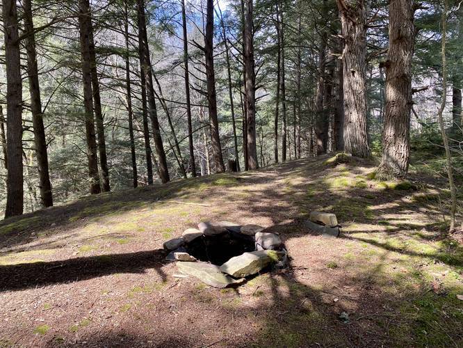
Backpackers will find plenty of campsites along this trail, including a few campsites right near Sand Run Falls itself. One campsite has a view of the waterfall while the two other sites are within a very short proximity to the waterfall. Also note there is a campsite closer to the parking lot near the open field as well. All backpackers should follow the Tioga State Forest rules for backcountry/primitive/dispersed camping.
Parking
Hikers will find there is only parking available for about two vehicles at the trailhead here. Hikers will also find another tiny parking turnout that's used often for access to this trail, which can be found at these coordinates: 41.685178, -77.197469. If either parking area appears to be full, please move on and try another time or head to the official Sand Run Falls Trail where parking is much more abundant. The property next to the trail here is technically private property with a public access right-of-way (i.e. the trail) so hikers must park at their own risk. Additionally, parking any further down the road may cause traffic issues as the trail sits on a curve in the road.
Pets
Dogs are allowed if leased.
Blaze Color
This trail follows the orange blazes as of April 3, 2020. Please note that these orange blazes are NOT associated with the Mid State Trail despite the Tioga State Forest trail map pdf.
Prohibited
No horses or biking along this trail.
Regardless, this trail is considered easy since it's very flat leading most of the way to Sand Run Falls. Hikers should be aware of the dangers leading down to the waterfall, so please read the warnings before heading out and expect a steep downhill climb next to the waterfall.
Along the trail hikers will find wild ramps during the spring, along with plenty of mud during the first half of the hike. The best time to visit Sand Run Falls is after a heavy rain, which means this trail will likely be wet and muddy unless you visit during the dry Summer.
The trail is easy to follow and about half-way through, there will be a small but wide waterfall along the creek adjacent to this trail (shown in the map) and next to it is a 10-foot tall rock ledge that arches over the creek.
As you approach the top of Sand Run Falls, there will be a campsite to your left. Hike just a bit further to find the top of Sand Run Falls and eventually over to the ropes that lead down to the base of the waterfall. Use the ropes cautiously to head downhill to the base of Sand Run Falls. At the base of the waterfall, hikers will find beautiful views of Sand Run Falls itself along with an amazing campsite.
From here, the hike is finished unless you wish to view extra waterfalls along the Sand Run Falls Trail - only if you can manage to cross Sand Run Creek to make it to the other side. Please note that these other, smaller waterfalls, are not far away from Sand Run Falls at all, but they may be difficult to get to if you cannot cross Sand Run Creek. Please study the Sand Run Falls Trail map before planning to locate the additional waterfalls here.
Must-Read Note
Shortly after hiking down the hill from the parking area, there will be an open field along the trail with a small campsite. Just beyond this campsite, the main service road turns and continues along a wide trail -- this wide service road is not the trail you must follow. The trail you must follow is located near the turn in this service road near the back of the field -- hike down the skinny trail that heads immediately downhill and then continue hiking along the orange blazed trail to find you way to Sand Run Falls.
Danger
Steep terrain: Reaching the base of Sand Run Falls follows a very steep hillside full of rocks and roots that's about 30-feet tall. Along this hillside is a set of ropes that helps hikers climb down to the base of the waterfall and the campsite below. This section of the trail may not be suited for all hikers, but there's still a nice vista of Sand Run Falls from the trail before the descent to the base of the waterfall. Hike at your own risk.
Rattlesnakes: While rare, the Timber Rattlesnake lives in this area and tends to come down to creeks to cool down or hunt between the end of April through the end of September. Watch your step and give any rattlesnake you see some space.
Camping and Backpacking
Backpackers will find plenty of campsites along this trail, including a few campsites right near Sand Run Falls itself. One campsite has a view of the waterfall while the two other sites are within a very short proximity to the waterfall. Also note there is a campsite closer to the parking lot near the open field as well. All backpackers should follow the Tioga State Forest rules for backcountry/primitive/dispersed camping.
Parking
Hikers will find there is only parking available for about two vehicles at the trailhead here. Hikers will also find another tiny parking turnout that's used often for access to this trail, which can be found at these coordinates: 41.685178, -77.197469. If either parking area appears to be full, please move on and try another time or head to the official Sand Run Falls Trail where parking is much more abundant. The property next to the trail here is technically private property with a public access right-of-way (i.e. the trail) so hikers must park at their own risk. Additionally, parking any further down the road may cause traffic issues as the trail sits on a curve in the road.
Pets
Dogs are allowed if leased.
Blaze Color
This trail follows the orange blazes as of April 3, 2020. Please note that these orange blazes are NOT associated with the Mid State Trail despite the Tioga State Forest trail map pdf.
Prohibited
No horses or biking along this trail.