The Sand Run Falls Trail at Tioga State Forest near Wellsboro, Pennsylvania is a moderate 6.9-mile loop trail that leads out to the popular waterfall, Sand Run Falls. For a shorter and easier hike to reach the base of Sand Run Falls, check out our other Sand Run Falls Hike guide.
This trail is considered easy to moderate difficulty, but can be very muddy during wet seasons so proper footwear is recommended. The trail offers several ways to reach Sand Run Falls via red blazes, but this trek follows the orange blazes along the Mid State Trail out to Sand Run Falls before heading back along the red blazed Sand Run Falls Trail.
The hike out to Sand Run Falls is about 3.5-miles one-way and is mostly all flat or downhill hiking through a mixed forest of deciduous and coniferous trees. The way back is similar; however, the hiking begins as uphill before flattening out as the trail gets closer to the parking lot.
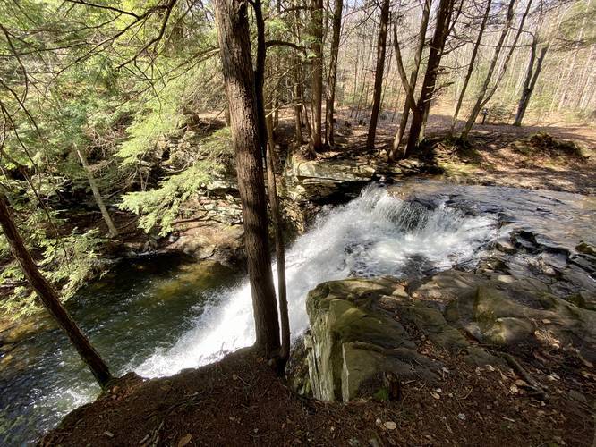
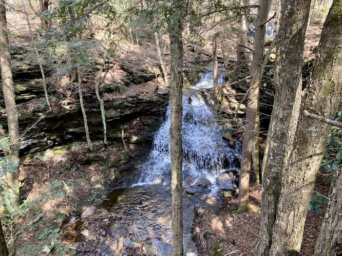
As hikers get close to Sand Run Falls, they'll reach a marker labeled "10" with signage for Sand Run Falls - from here, the waterfall is only about 0.2-miles away. The trail runs along a cliff's edge for a short while before the waterfall is visible within the ravine below. Hikers will get a chance to sit atop the waterfall and get views from the side of the falls. If hiking this trail during the Summer, the creek should be dry enough to cross easily without any issues; however, during the wetter months, Sand Run creek is fairly deep and difficult to cross.
Before heading back to parking, check out the two additional waterfalls near Sand Run Falls - located off of the short spur trail on the map. Hiking back along the red blazes requires an easy creek crossing and several undulating hills, but should not be considered any more difficult than moderate at best.
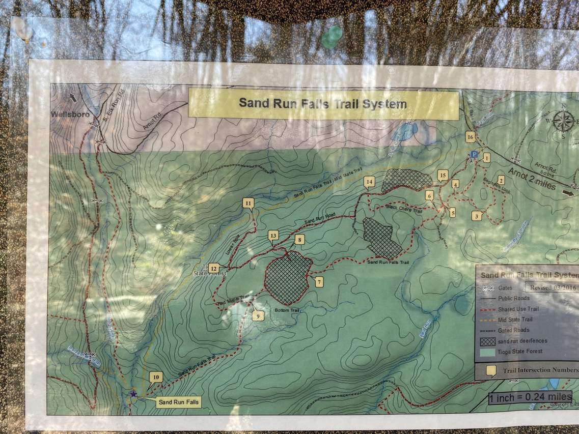
Trail Names and Route
Technically, this entire loop trail is named the Sand Run Falls Trail. The northern section of the loop follows the Mid State Trail as this section is technically two trails that follow the same path. On the return route, this trail data includes sections between markers 10 to 9, 9 to 7, 7 to 6, 6 to 5, 5 to 4, and 4 to 1. These trail markers are used to find your location out on the trails easier - please use this map as a reference.
Reaching Sand Run Falls
This popular waterfall in Tioga State Forest is about 30 feet tall and 10 feet wide. Also note that when Sand Run creek is flowing heavily, this route to Sand Run Falls will only bring you to the top of the waterfall and not the base of the waterfall. Hikers can you choose to get their feet wet in the 1-foot deep creek to cross the creek above the waterfall, however, since the only path to the base of the falls is on the other side of the creek. If you wish to hike this trail while Sand Run creek is running strong, try our other Sand Run Falls Hike guide instead - that hike is about half of the distance and will guarantee that you reach the base of Sand Run Falls; however, parking is limited.
Jax Falls (Additional Waterfalls)
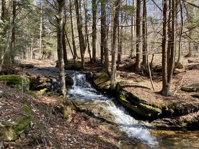
There are two more waterfalls along a separate creek along this hike, named Jax Falls. Both waterfalls can be found near the location of Sand Run Falls. As you hike in toward Sand Run Falls, there's a sign with an arrow stating "Sand Run Falls", but there's a small trail that cuts off to the left behind this sign. Hike down this tiny trail and you'll find a short 5-foot waterfall along this creek. Hike across the creek and down through the conifer grove for a couple dozen more feet to find another waterfall, Jax Falls, about 15 to 20-feet tall, cascading down the creek.
Camping / Backpacking
Backpackers will find dispersed/backcountry/primitive camping options along this trail; however, the only designated campsites we found were near Sand Run Falls itself. Also note that both campsites were located on the opposite side of the creek from where this trail will lead you to. If backpacking the Mid State Trail anyway, crossing this creek is a must-do since the Mid State Trail crosses at the top of the waterfall.
Parking
Hikers will find the main parking lot at the coordinates provided. The lot is large enough for about a dozen vehicles.
Blaze Colors
This trek follows orange blazes along the Mid State Trail along the northern half of the loop and along the spur section that leads to Sand Run Falls. Along the southern half of the loop, the trail follows red blazes along the Sand Run Falls Trail.
Pets
Dogs are allowed if leashed.
Warnings
Rattlesnakes: While rare, the Timber Rattlesnake lives in this area and tends to come down to creeks to cool down or hunt between the end of April through the end of September. Watch your step and give any rattlesnake you see some space.
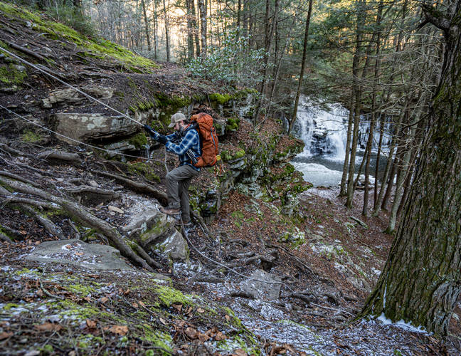
Steep terrain: If you cross the creek and hike down to the base of Sand Run Falls (not shown in the GPS data provided), you'll be faced with a steep hillside climb that includes with a rope for guidance.
This trail is considered easy to moderate difficulty, but can be very muddy during wet seasons so proper footwear is recommended. The trail offers several ways to reach Sand Run Falls via red blazes, but this trek follows the orange blazes along the Mid State Trail out to Sand Run Falls before heading back along the red blazed Sand Run Falls Trail.
The hike out to Sand Run Falls is about 3.5-miles one-way and is mostly all flat or downhill hiking through a mixed forest of deciduous and coniferous trees. The way back is similar; however, the hiking begins as uphill before flattening out as the trail gets closer to the parking lot.
As hikers get close to Sand Run Falls, they'll reach a marker labeled "10" with signage for Sand Run Falls - from here, the waterfall is only about 0.2-miles away. The trail runs along a cliff's edge for a short while before the waterfall is visible within the ravine below. Hikers will get a chance to sit atop the waterfall and get views from the side of the falls. If hiking this trail during the Summer, the creek should be dry enough to cross easily without any issues; however, during the wetter months, Sand Run creek is fairly deep and difficult to cross.
Before heading back to parking, check out the two additional waterfalls near Sand Run Falls - located off of the short spur trail on the map. Hiking back along the red blazes requires an easy creek crossing and several undulating hills, but should not be considered any more difficult than moderate at best.
Trail Names and Route
Technically, this entire loop trail is named the Sand Run Falls Trail. The northern section of the loop follows the Mid State Trail as this section is technically two trails that follow the same path. On the return route, this trail data includes sections between markers 10 to 9, 9 to 7, 7 to 6, 6 to 5, 5 to 4, and 4 to 1. These trail markers are used to find your location out on the trails easier - please use this map as a reference.
Reaching Sand Run Falls
This popular waterfall in Tioga State Forest is about 30 feet tall and 10 feet wide. Also note that when Sand Run creek is flowing heavily, this route to Sand Run Falls will only bring you to the top of the waterfall and not the base of the waterfall. Hikers can you choose to get their feet wet in the 1-foot deep creek to cross the creek above the waterfall, however, since the only path to the base of the falls is on the other side of the creek. If you wish to hike this trail while Sand Run creek is running strong, try our other Sand Run Falls Hike guide instead - that hike is about half of the distance and will guarantee that you reach the base of Sand Run Falls; however, parking is limited.
Jax Falls (Additional Waterfalls)
There are two more waterfalls along a separate creek along this hike, named Jax Falls. Both waterfalls can be found near the location of Sand Run Falls. As you hike in toward Sand Run Falls, there's a sign with an arrow stating "Sand Run Falls", but there's a small trail that cuts off to the left behind this sign. Hike down this tiny trail and you'll find a short 5-foot waterfall along this creek. Hike across the creek and down through the conifer grove for a couple dozen more feet to find another waterfall, Jax Falls, about 15 to 20-feet tall, cascading down the creek.
Camping / Backpacking
Backpackers will find dispersed/backcountry/primitive camping options along this trail; however, the only designated campsites we found were near Sand Run Falls itself. Also note that both campsites were located on the opposite side of the creek from where this trail will lead you to. If backpacking the Mid State Trail anyway, crossing this creek is a must-do since the Mid State Trail crosses at the top of the waterfall.
Parking
Hikers will find the main parking lot at the coordinates provided. The lot is large enough for about a dozen vehicles.
Blaze Colors
This trek follows orange blazes along the Mid State Trail along the northern half of the loop and along the spur section that leads to Sand Run Falls. Along the southern half of the loop, the trail follows red blazes along the Sand Run Falls Trail.
Pets
Dogs are allowed if leashed.
Warnings
Rattlesnakes: While rare, the Timber Rattlesnake lives in this area and tends to come down to creeks to cool down or hunt between the end of April through the end of September. Watch your step and give any rattlesnake you see some space.
Steep terrain: If you cross the creek and hike down to the base of Sand Run Falls (not shown in the GPS data provided), you'll be faced with a steep hillside climb that includes with a rope for guidance.


