The Horse Run Old-Growth Hemlocks along the West Rim Trail at Tioga State Forest near Gaines, Pennsylvania is a moderate 3.5-mile out-and-back hike that leads to a stand of virgin Eastern Hemlocks. These hemlock trees were spared during the logging era due to a land boundary dispute and today (as of May, 2022) exceed ages of over 180-years old with the largest Eastern Hemlock, the "Mother Tree", as old as ~220 to 250 years or more.
Trails
This hike follows two named trails: Seimons Trail (yellow blazes), West Rim Trail (orange blazes).
Hike Description
This hike begins at the western trailhead for the Seimons Trail along West Rim Road and follows the entirety of the Seimons Trail to reach the West Rim Trail.
At the West Rim Trail, continue hiking straight to head south following orange blazes. Along the way are some campsites for backpackers and some old-growth Red Oak and Eastern Hemlocks; however, the oldest Eastern Hemlocks sit just above Horse Run.
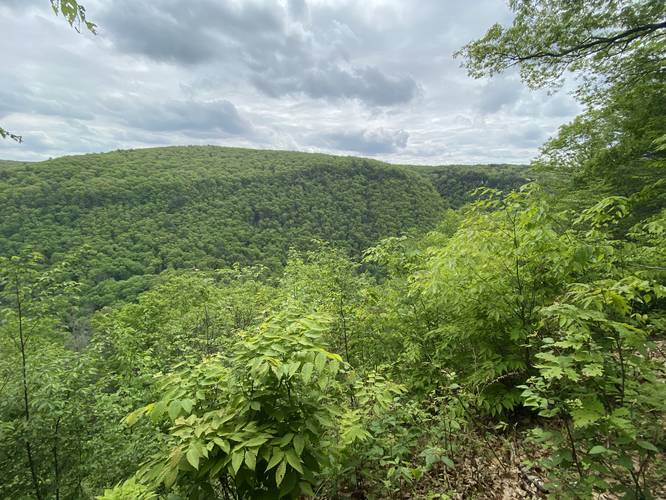
Canyon Vista - Mile 1.2
Around mile 1.2, hikers will find a vista that peers into the PA Grand Canyon just off-trail from the West Rim Trail.
Horse Run Creek Crossing / Campsite in Hemlock Grove - Mile 1.6
Around mile 1.6, hikers will reach the creek crossing at Horse Run. Here, head straight across the creek and then immediately take a right-hand turn to hike up into a hemlock grove. At the top of the hill, about 100-feet from the creek, is a nice campsite for backpackers that sits within this grove.
Old-Growth Eastern Hemlock Grove - Mile 1.7
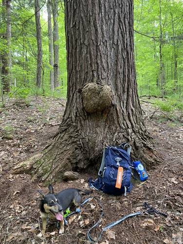
After passing the campsite just off of Horse Run, hikers will continue heading up Horse Run for another ~150-feet or so before finding yet another Eastern Hemlock grove across the creek. Alternatively, hikers can choose to NOT cross Horse Run and bushwhack out to the Old-Growth Hemlock grove instead... regardless, the old-growth Eastern Hemlock trees should be fairly obvious to the hiker as they tower over Horse Run about 250-feet upstream from the West Rim Trail creek crossing. Upon this hike in late May 2022, I decided to measure these trees to attempt to age them and then send that data to Tioga State Forest - and also to document here. The largest tree, which I'll nickname the "Mother Tree" is easy to spot as it has a tumor / growth on the creek-side of the tree (south side). The "Mother Tree" came in at ~121.5-inches in circumference, which calculates to ~98.23361397517965 cm D.b.h (diameter at breast height), which is equivalent to ~240 to 250-years old according to this USFS info chart on the Eastern Hemlock. Just to the east of this tree was yet another old-growth Eastern Hemlock that appeared to be a similar size an age, but was measured at 111.5 inches in circumference whose D.b.h measured ~90.14854286611136 cm, which is ~220-years old. Note that the age of all of these old trees may be vastly underestimated, especially if they were growing in dense forest as young saplings, as that would have slowed their growth rate as young saplings.
Hiking Out
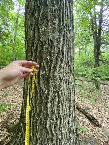
As an out-and-back, the hike back to parking is fairly obvious that it's just the opposite hike; however, the undulation and the gradual ascent out from the canyon is a bit harder than it looks, hence the moderate difficulty. On the way out I decided to measure more large Eastern Hemlock and Red Oak trees that were right on the West Rim Trail. Most of the hemlocks measured were between 97 - 109.5 inches in circumference which would translate to ~150-years old to ~175 years old. These old-growth Eastern Hemlocks are located on-trail between the canyon vista and Horse Run.
Parking
Hikers will find a small parking turnout near the trailhead for the Seimons Trail and West Rim Trail right along West Rim Road at the coordinates provided. The turnout is large enough for one or two vehicles (basically park along, but not blocking the O'Connor Trail).
Pets
Dogs are allowed if leashed and their waste should be carried out by the hiker.
Backpacking and Camping
Backpacking is allowed on both trails here and there are plenty of campsites, mostly located along the West Rim Trail. Please follow all state forest rules and regulations when dispersed / primitive / backcountry camping.
Trails
This hike follows two named trails: Seimons Trail (yellow blazes), West Rim Trail (orange blazes).
Hike Description
This hike begins at the western trailhead for the Seimons Trail along West Rim Road and follows the entirety of the Seimons Trail to reach the West Rim Trail.
At the West Rim Trail, continue hiking straight to head south following orange blazes. Along the way are some campsites for backpackers and some old-growth Red Oak and Eastern Hemlocks; however, the oldest Eastern Hemlocks sit just above Horse Run.
Canyon Vista - Mile 1.2
Around mile 1.2, hikers will find a vista that peers into the PA Grand Canyon just off-trail from the West Rim Trail.
Horse Run Creek Crossing / Campsite in Hemlock Grove - Mile 1.6
Around mile 1.6, hikers will reach the creek crossing at Horse Run. Here, head straight across the creek and then immediately take a right-hand turn to hike up into a hemlock grove. At the top of the hill, about 100-feet from the creek, is a nice campsite for backpackers that sits within this grove.
Old-Growth Eastern Hemlock Grove - Mile 1.7
After passing the campsite just off of Horse Run, hikers will continue heading up Horse Run for another ~150-feet or so before finding yet another Eastern Hemlock grove across the creek. Alternatively, hikers can choose to NOT cross Horse Run and bushwhack out to the Old-Growth Hemlock grove instead... regardless, the old-growth Eastern Hemlock trees should be fairly obvious to the hiker as they tower over Horse Run about 250-feet upstream from the West Rim Trail creek crossing. Upon this hike in late May 2022, I decided to measure these trees to attempt to age them and then send that data to Tioga State Forest - and also to document here. The largest tree, which I'll nickname the "Mother Tree" is easy to spot as it has a tumor / growth on the creek-side of the tree (south side). The "Mother Tree" came in at ~121.5-inches in circumference, which calculates to ~98.23361397517965 cm D.b.h (diameter at breast height), which is equivalent to ~240 to 250-years old according to this USFS info chart on the Eastern Hemlock. Just to the east of this tree was yet another old-growth Eastern Hemlock that appeared to be a similar size an age, but was measured at 111.5 inches in circumference whose D.b.h measured ~90.14854286611136 cm, which is ~220-years old. Note that the age of all of these old trees may be vastly underestimated, especially if they were growing in dense forest as young saplings, as that would have slowed their growth rate as young saplings.
Hiking Out
As an out-and-back, the hike back to parking is fairly obvious that it's just the opposite hike; however, the undulation and the gradual ascent out from the canyon is a bit harder than it looks, hence the moderate difficulty. On the way out I decided to measure more large Eastern Hemlock and Red Oak trees that were right on the West Rim Trail. Most of the hemlocks measured were between 97 - 109.5 inches in circumference which would translate to ~150-years old to ~175 years old. These old-growth Eastern Hemlocks are located on-trail between the canyon vista and Horse Run.
Parking
Hikers will find a small parking turnout near the trailhead for the Seimons Trail and West Rim Trail right along West Rim Road at the coordinates provided. The turnout is large enough for one or two vehicles (basically park along, but not blocking the O'Connor Trail).
Pets
Dogs are allowed if leashed and their waste should be carried out by the hiker.
Backpacking and Camping
Backpacking is allowed on both trails here and there are plenty of campsites, mostly located along the West Rim Trail. Please follow all state forest rules and regulations when dispersed / primitive / backcountry camping.