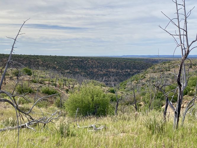
The Farming Terrace Loop Trail at Mesa Verde National Park, Colorado is a moderate 0.5-mile loop hike that features views into Soda Canyon and passes through an ancient farming terrace on the canyon's slopes.
Hike
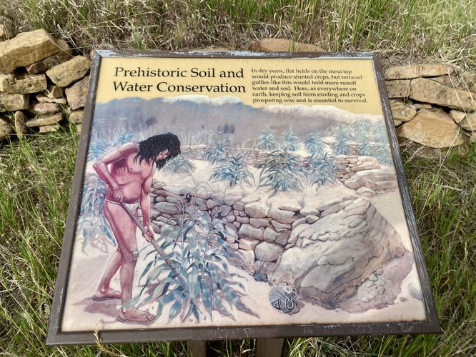
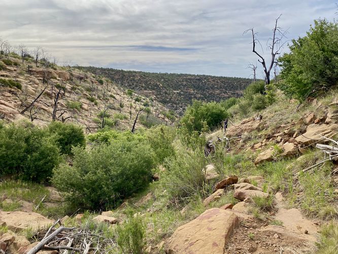
This very short hike begins at the main trailhead for the Farming Terrace Loop and heads in along the western side of the trail is slowly leads downhill. The trail leads through a mostly-open space with low-growing bushes and trees where you'll also find evidence of wildfire. The trail eventually reaches an information kiosk before it descends further -- this info kiosk explains how and why the ancient Puebloans used this part of the canyon (and others like it) to farm, generally due to the abundance of water in canyon gully like these.
The trail then descends further into Soda Canyon's shallow gully where you'll face a rocky trail that passes through this ancient farming terrace. The trail then leads up and out of the gully where it quickly meets back up with the road. Once on the road, walk just a couple-hundred feet back to parking to complete the 0.5-mile loop.
Wildlife Viewing
This trail is great for viewing wildlife -- especially the wild horses that reside within and around Mesa Verde National Park. Depending on the time of day, you might just get lucky enough to see wild horses along the trail. Always keep a safe distance when viewing wildlife and provide wild horses with at least 60-feet of space.
Parking
Visitors will find a parking lot at the coordinates provided along Cedar Tree Road in the park. As of June 2024, the lot is large enough to fit about 3 vehicles.
Pets
Dogs are not allowed on this trail. Dogs are allowed on paved trails including the Park Point Trail and the Mesa Top Loop Sites including: The Navajo Canyon Overlook, Square Tower House Overlook Trail, Pithouses & Pueblos Loop, Mesa Top Sites Trail, Sun Point Pueblo, Sun Point View, Oak Tree House View, Fire Temple & New Fire House View, and the Sun Temple & Cliff Palace View.
Warning
Rattlesnakes: Mesa Verde is home to rattlesnakes that might be out basking in the sun during warm months. While encounters are rare, give any rattlers you find plenty of space.
Sun exposure: Due to the lack of trees and shade, this trail has a high exposure to the sun and weather. Plan to bring sunscreen to protect yourself against high UVs.
Hike
This very short hike begins at the main trailhead for the Farming Terrace Loop and heads in along the western side of the trail is slowly leads downhill. The trail leads through a mostly-open space with low-growing bushes and trees where you'll also find evidence of wildfire. The trail eventually reaches an information kiosk before it descends further -- this info kiosk explains how and why the ancient Puebloans used this part of the canyon (and others like it) to farm, generally due to the abundance of water in canyon gully like these.
The trail then descends further into Soda Canyon's shallow gully where you'll face a rocky trail that passes through this ancient farming terrace. The trail then leads up and out of the gully where it quickly meets back up with the road. Once on the road, walk just a couple-hundred feet back to parking to complete the 0.5-mile loop.
Wildlife Viewing
This trail is great for viewing wildlife -- especially the wild horses that reside within and around Mesa Verde National Park. Depending on the time of day, you might just get lucky enough to see wild horses along the trail. Always keep a safe distance when viewing wildlife and provide wild horses with at least 60-feet of space.
Parking
Visitors will find a parking lot at the coordinates provided along Cedar Tree Road in the park. As of June 2024, the lot is large enough to fit about 3 vehicles.
Pets
Dogs are not allowed on this trail. Dogs are allowed on paved trails including the Park Point Trail and the Mesa Top Loop Sites including: The Navajo Canyon Overlook, Square Tower House Overlook Trail, Pithouses & Pueblos Loop, Mesa Top Sites Trail, Sun Point Pueblo, Sun Point View, Oak Tree House View, Fire Temple & New Fire House View, and the Sun Temple & Cliff Palace View.
Warning
Rattlesnakes: Mesa Verde is home to rattlesnakes that might be out basking in the sun during warm months. While encounters are rare, give any rattlers you find plenty of space.
Sun exposure: Due to the lack of trees and shade, this trail has a high exposure to the sun and weather. Plan to bring sunscreen to protect yourself against high UVs.