The Chimney Hollow Falls Winter Hike at Tioga State Forest in Wellsboro, Pennsylvania is a difficult 4-mile out-and-back trek that leads to a large 40+ foot waterfall, Chimney Follow Falls, aka Owassee Slide Falls.
This is an alternative route to reach the waterfall because the service road that leads to the creek where the waterfall sits is not maintained during the winter.
Waterfall's Height
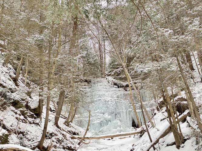
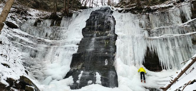
This waterfall is a multi-tiered waterfall that has several cascades. The entire waterfall, including the upper and lower falls is about 60 to 70-feet tall. During the winter, the free falling cascade, which is about 40-feet tall, is frozen over and visible. The lower falls is often covered in snow and hard to see.
Trails
Hikers will follow the West Rim Trail until they reach Owassee Road which leads to Chimney Follow Falls / Owassee Slide Falls.
Hike Description
The trail begins at the northern trailhead of the West Rim Trail and follows the orange blazes of the WRT until the hiker reaches Owassee Road. From here, the hiker follows Owassee Road downhill and alongside Pine Creek.
The section of forest that leads from the trailhead, down to the banks of Pine Creek, is mostly coniferous, which makes this a beautiful winter hike if the snow has recently fallen.
Around mile 1.8, hikers will reach the culvert for Owassee Slide Run as it passes underneath Owassee Road. Here, hikers will bushwhack their way uphill along the southern side of the creek to reach a view point of Chimney Hollow Falls / Owassee Slide Falls.
The hike up along the hills leading to the waterfall are very steep alongside the creek, so hikers will want to stay away from the slopes as they hike toward the waterfall.
Warnings
Hikers should note two things: first, the slopes alongside Owassee Slide Run creek, where hikers get a view point of the waterfall, is extremely dangerous during the winter because of the very steep slopes. Hikers must come prepared with ice spikes, trekking poles, and the proper footwear at the very least to ensure their safety. Second, Colton Point Road, the road that hikers will park off of - is not maintained during the winter. If there is minimal ice and snow, hikers can technically drive within 0.2-miles of the waterfall instead of hiking the 4-miles out-and-back; however, if snow and ice have built-up on the roads, hikers will be forced to hike this route to the waterfall.
Parking
Hikers will find parking at the coordinates provided, which is the West Rim Trail's northern parking lot.
Pets
Dogs are allowed if leashed; however, be mindful of the dangerous conditions this trail as it might not be suited for all dogs.
Season
This route can be hiked year-round, but is best during the winter when there's no road access and very few (if any) other hikers trekking along this path.
Biking
Winter biking is permitted, but not along the West Rim Trail section of this trek. Bikers can alternatively take the Colton Point Road up to Owassee Road to reach the waterfall.
This is an alternative route to reach the waterfall because the service road that leads to the creek where the waterfall sits is not maintained during the winter.
Waterfall's Height
This waterfall is a multi-tiered waterfall that has several cascades. The entire waterfall, including the upper and lower falls is about 60 to 70-feet tall. During the winter, the free falling cascade, which is about 40-feet tall, is frozen over and visible. The lower falls is often covered in snow and hard to see.
Trails
Hikers will follow the West Rim Trail until they reach Owassee Road which leads to Chimney Follow Falls / Owassee Slide Falls.
Hike Description
The trail begins at the northern trailhead of the West Rim Trail and follows the orange blazes of the WRT until the hiker reaches Owassee Road. From here, the hiker follows Owassee Road downhill and alongside Pine Creek.
The section of forest that leads from the trailhead, down to the banks of Pine Creek, is mostly coniferous, which makes this a beautiful winter hike if the snow has recently fallen.
Around mile 1.8, hikers will reach the culvert for Owassee Slide Run as it passes underneath Owassee Road. Here, hikers will bushwhack their way uphill along the southern side of the creek to reach a view point of Chimney Hollow Falls / Owassee Slide Falls.
The hike up along the hills leading to the waterfall are very steep alongside the creek, so hikers will want to stay away from the slopes as they hike toward the waterfall.
Warnings
Hikers should note two things: first, the slopes alongside Owassee Slide Run creek, where hikers get a view point of the waterfall, is extremely dangerous during the winter because of the very steep slopes. Hikers must come prepared with ice spikes, trekking poles, and the proper footwear at the very least to ensure their safety. Second, Colton Point Road, the road that hikers will park off of - is not maintained during the winter. If there is minimal ice and snow, hikers can technically drive within 0.2-miles of the waterfall instead of hiking the 4-miles out-and-back; however, if snow and ice have built-up on the roads, hikers will be forced to hike this route to the waterfall.
Parking
Hikers will find parking at the coordinates provided, which is the West Rim Trail's northern parking lot.
Pets
Dogs are allowed if leashed; however, be mindful of the dangerous conditions this trail as it might not be suited for all dogs.
Season
This route can be hiked year-round, but is best during the winter when there's no road access and very few (if any) other hikers trekking along this path.
Biking
Winter biking is permitted, but not along the West Rim Trail section of this trek. Bikers can alternatively take the Colton Point Road up to Owassee Road to reach the waterfall.