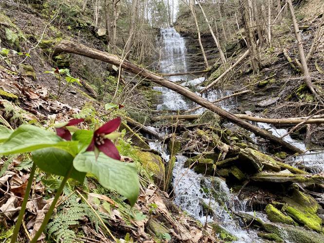
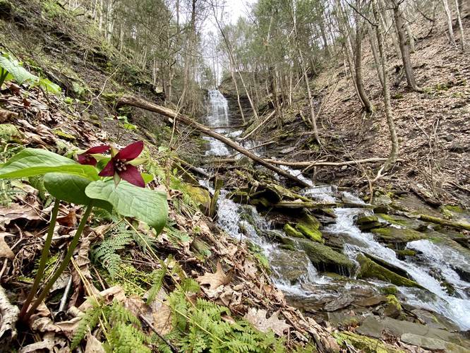
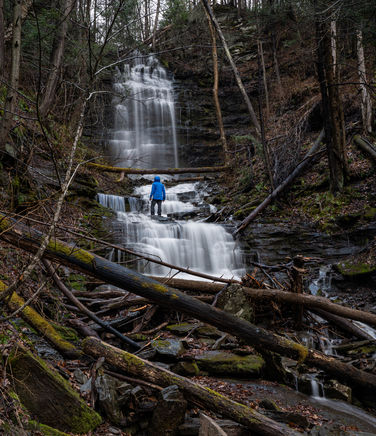
Chimney Hollow Falls at Tioga State Forest near Wellsboro, Pennsylvania is a two-tiered 60 to 70-foot tall waterfall that spills down Owassee Slide Run creek. The hike to reach Chimney Hollow Falls is mostly moderate as this 0.3-mile out-and-back trail leads through a bushwhack to reach the falls.
This hike does not follow any trails and thus hikers must use caution when trying to reach Chimney Hollow Falls. The easiest way to reach the waterfall is to stay along the left-hand side of Owassee Slide Run.
Hikers will find that deer and other occasional explorers have pushed their way through brush to reach the waterfall; however, following the route of least resistance is not always recommended since this path runs directly along very steep hillsides that can cause serious harm if you slip and fall.
Just before reaching the base of the waterfall, hikers will head uphill before the ground levels out a bit more. As the ground levels out, the waterfall will come into clear view and then the sketchy 'trail' will head downhill and along the creek which features a stunning view of Chimney Hollow Falls.
The Route to Reach Chimney Hollow Falls
Hikers should know that this route does not follow a trail and you will have to push your way through brush and hike over blowdowns to get to the waterfall. Stay to the left-hand side (south side) of Owassee Slide Run creek and you'll find the waterfall.
Upper Chimney Hollow Falls
Hikers will mostly just get a view of Upper Chimney Hollow Falls, which is the first tier of the waterfall and sends water free-falling for about 40-feet. The reason hikers usually cannot reach this section of the waterfall is because of the extremely steep slopes of the hills surrounding Lower Chimney Hollow Falls. However, hikers can get a photo of the entire waterfall from the base of Lower Chimney Hollow Falls.
Lower Chimney Hollow Falls
The hike essentially ends at Lower Chimney Hollow Falls, which is a 25 to 30-foot multi-tier cascade of Chimney Hollow Falls. This scenic section of the waterfall is the closest hikers can get without putting themselves in further danger of getting hurt among the rocks and water.
Parking
Hikers can find a small parking lot, large enough to fit about three vehicles, at the coordinates provided.
Road Maintenance
Please note that this road is not maintained during the winter and neither is the road that leads to Owassee Road. Additionally during times of high flooding, the road may be completely flooded by Pine Creek. Last, the potholes that line the road can also be massive, so smaller low-to-the-ground cars may have a difficult time driving this road.
Danger
Steep terrain: This trail can be dangerous especially along the creek as there are several steep drop-offs that hikers can accidentally fall down on the way up to Chimney Hollow Falls. Hike at your own risk.
Rattlesnakes: While rare, the Timber Rattlesnake lives in this area and tends to come down to creeks to cool down or hunt between the end of April through the end of September. Watch your step and give any rattlesnake you see some space.
Trillium Wildflowers
During the early Spring - around mid-April, hikers can find trillium growing in this area of Tioga State Forest. Additionally, tons of trillium grow along the hike, so watch your step.