Cedar Mountain Vistas at Tioga State Forest near Gaines, Pennsylvania is a moderate 4.2-mile out-and-back hike that leads to Grand View and several other vistas along Cedar Mountain's southeastern ridge.
Hike Description
This hike begins along Mill Run Rd at the small parking turnout by the yellow service road gate and follows the service road in toward the eastern summit of Cedar Mountain. The trail will slowly make its way up a ~130-foot ascent to reach a set of radio towers. At the radio towers, hikers will want to take a left-hand turn to head toward Grand View.
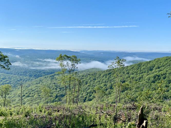
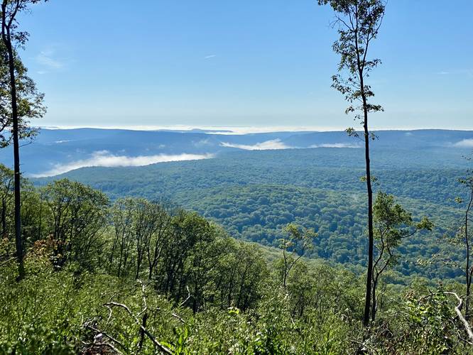
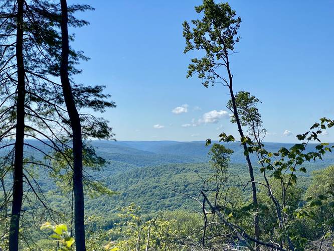
Grand View - Mile 0.7
Around mile 0.7, hikers will reach "Grand View", which is located just below the highest summit in Tioga County. As of August, 2022, the view from this logged area is stunning, hence the name. Hikers get a view into Pine Creek Gorge (PA Grand Canyon) with a view of Pine Island Vistas jagged, rocky, and red-ish ledges along with sweeping views south into Tioga State Forest and northern sections of Tiadaghton State Forest on a clear day. After taking in the views, hikers will want to make their way back toward the radio towers and then south along the logging road to reach even more views.
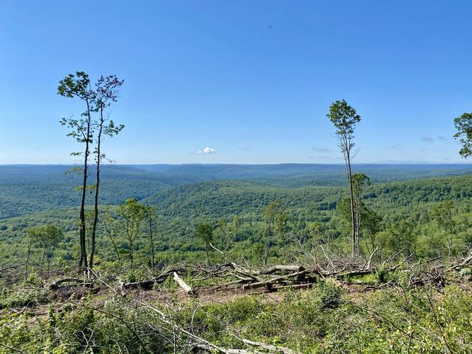
South Ridge Hiking - Mile 0.9
At the radio towers, around mile 0.9 (after visiting Grand View), head south and follow the logging road. As of August, 2022 there was a large rock pile with a small view between the trees located around mile 1.33; however, if you continue south along the logging road for just a few-hundred more feet, there's a small "trail" that was cut out by a logging machine that leads to a loosely-defined path that skirts around the southern boarder of the logging area - from here, there are a few more vistas.
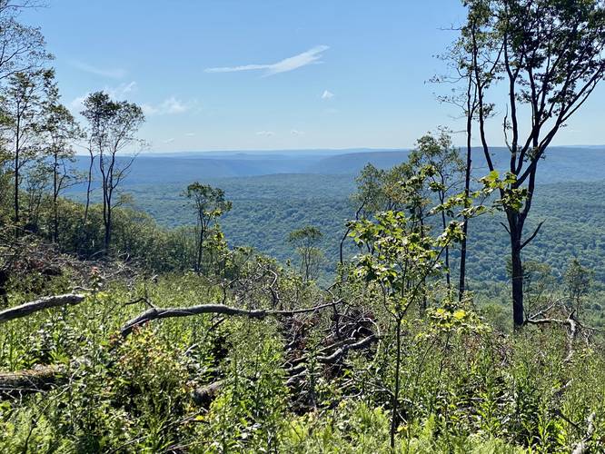
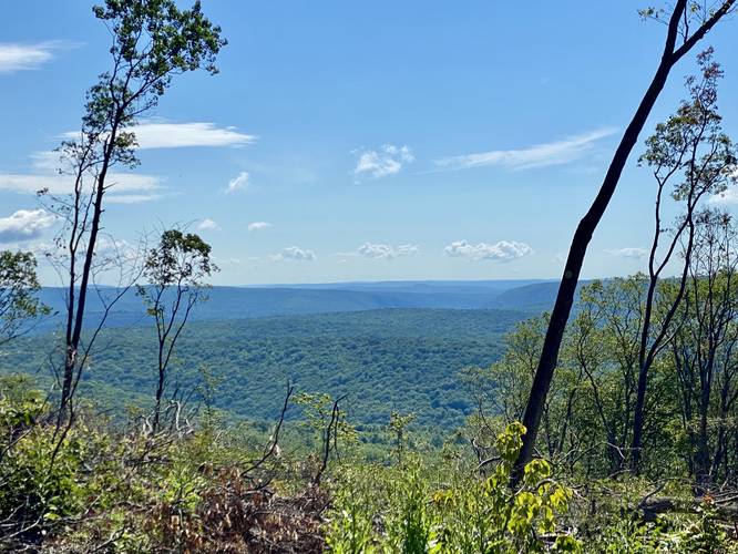
South Ridge Vistas - Mile 1.45 to 1.77
At mile 1.45, after taking a left-hand turn off of the logging road, hikers will walk through a clear-cut logging area that leads out to a steeper grade of the mountain which provides some nice south-facing views; however, this section is a bit more of a light bushwhack during the Summer. Hikers will want to walk closer to the treeline to follow the loosely-defined path that a bobcat or other excavating machine had trenched prior. Along the way are views facing easterly to southwest. Around mile 1.6, the "bushwhack" portion will meet up once again with the logging road. There's a nice shady spot to sit down and enjoy a snack before hiking onward; however, there's not much more to see from here. There are a couple more views facing southeast if you continue hiking the ridgeline, located around mile 1.7 and mile 1.77.
Woods Hiking - Mile 1.77 to 2.1
After passing the last vista around mile 1.77, hikers will then be lead back into the woods where the logging road ends. The trail will meander its way uphill along a "hump" in the mountain's ridge before dropping in elevation again. On this hike, we followed this trail until we reached some blowdown trees - after checking our position on the map, we decided there were likely no more views and decided to hike back to Grand View before heading out.
Hiking Out
Despite the elevation profile and overall gain, the hike out is not very difficult. The worst section leads up from the off-trail vistas (if you wish to take that route back) up to the eastern summit of Cedar Mountain. Additionally, the hike back up from Grand View is a bit difficult, but does not last for very long either. Overall the difficulty should be considered moderate for that reason.
Parking
Hikers will find a very small parking turnout by the forest gate and trailhead. The lot is large enough for a couple of vehicles. Do not block the forest gate.
Pets
Dogs are allowed if leashed and their waste should be carried out by the hiker.
Camping and Backpacking
Note that dispersed / primitive / backcountry camping is allowed within Tioga State Forest and off of this trail. We found one campfire ring at the parking lot - which appeared to be a off-road car campsite. Please follow all state forest rules when disperse / primitive / backcountry camping at Tioga State Forest.
Warning
Timber Rattlesnakes: This area is known to inhabit the Timber Rattlesnake which can often be found sunning itself between late April and early October, especially on rocky outcroppings or in exposed areas, near downed trees, on-trail, or in the brush just off-trail.
No water: There's no water to filter along this route, so pack in everything you need.
Hunting & Service Gate
As of October 2022, the service road gate is open to hunters from October 15th - January 16th 2023. For hikers, it's probably best to walk this service road so that you don't put additional wear/tear on the road, leaving it less rutted for hunter's vehicles.
Hike Description
This hike begins along Mill Run Rd at the small parking turnout by the yellow service road gate and follows the service road in toward the eastern summit of Cedar Mountain. The trail will slowly make its way up a ~130-foot ascent to reach a set of radio towers. At the radio towers, hikers will want to take a left-hand turn to head toward Grand View.
Grand View - Mile 0.7
Around mile 0.7, hikers will reach "Grand View", which is located just below the highest summit in Tioga County. As of August, 2022, the view from this logged area is stunning, hence the name. Hikers get a view into Pine Creek Gorge (PA Grand Canyon) with a view of Pine Island Vistas jagged, rocky, and red-ish ledges along with sweeping views south into Tioga State Forest and northern sections of Tiadaghton State Forest on a clear day. After taking in the views, hikers will want to make their way back toward the radio towers and then south along the logging road to reach even more views.
South Ridge Hiking - Mile 0.9
At the radio towers, around mile 0.9 (after visiting Grand View), head south and follow the logging road. As of August, 2022 there was a large rock pile with a small view between the trees located around mile 1.33; however, if you continue south along the logging road for just a few-hundred more feet, there's a small "trail" that was cut out by a logging machine that leads to a loosely-defined path that skirts around the southern boarder of the logging area - from here, there are a few more vistas.
South Ridge Vistas - Mile 1.45 to 1.77
At mile 1.45, after taking a left-hand turn off of the logging road, hikers will walk through a clear-cut logging area that leads out to a steeper grade of the mountain which provides some nice south-facing views; however, this section is a bit more of a light bushwhack during the Summer. Hikers will want to walk closer to the treeline to follow the loosely-defined path that a bobcat or other excavating machine had trenched prior. Along the way are views facing easterly to southwest. Around mile 1.6, the "bushwhack" portion will meet up once again with the logging road. There's a nice shady spot to sit down and enjoy a snack before hiking onward; however, there's not much more to see from here. There are a couple more views facing southeast if you continue hiking the ridgeline, located around mile 1.7 and mile 1.77.
Woods Hiking - Mile 1.77 to 2.1
After passing the last vista around mile 1.77, hikers will then be lead back into the woods where the logging road ends. The trail will meander its way uphill along a "hump" in the mountain's ridge before dropping in elevation again. On this hike, we followed this trail until we reached some blowdown trees - after checking our position on the map, we decided there were likely no more views and decided to hike back to Grand View before heading out.
Hiking Out
Despite the elevation profile and overall gain, the hike out is not very difficult. The worst section leads up from the off-trail vistas (if you wish to take that route back) up to the eastern summit of Cedar Mountain. Additionally, the hike back up from Grand View is a bit difficult, but does not last for very long either. Overall the difficulty should be considered moderate for that reason.
Parking
Hikers will find a very small parking turnout by the forest gate and trailhead. The lot is large enough for a couple of vehicles. Do not block the forest gate.
Pets
Dogs are allowed if leashed and their waste should be carried out by the hiker.
Camping and Backpacking
Note that dispersed / primitive / backcountry camping is allowed within Tioga State Forest and off of this trail. We found one campfire ring at the parking lot - which appeared to be a off-road car campsite. Please follow all state forest rules when disperse / primitive / backcountry camping at Tioga State Forest.
Warning
Timber Rattlesnakes: This area is known to inhabit the Timber Rattlesnake which can often be found sunning itself between late April and early October, especially on rocky outcroppings or in exposed areas, near downed trees, on-trail, or in the brush just off-trail.
No water: There's no water to filter along this route, so pack in everything you need.
Hunting & Service Gate
As of October 2022, the service road gate is open to hunters from October 15th - January 16th 2023. For hikers, it's probably best to walk this service road so that you don't put additional wear/tear on the road, leaving it less rutted for hunter's vehicles.