Pine Island Vistas at Tioga State Forest in Stony Fork, Pennsylvania is a strenuous 5.9-mile out-and-back hike that leads to several vista points along the east rim of Pine Creek Gorge (the PA Grand Canyon). This hike is meant only for the experienced hiker who can read topo maps, navigate the woods and ambiguous turns, can deal with looking for and spotting rattlesnakes, can handle light bushwhacking and overgrowth, and who can handle hiking in remote areas with massive cliffs, all of which can be dangerous. For those looking for almost the same view, but an easier and more accessible hike, it's recommended to hike Barbour Rock instead.
Hike Description
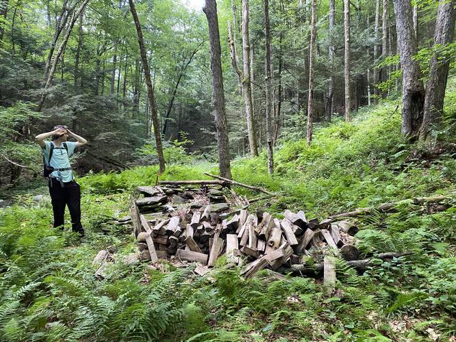
This hike begins at the trailhead for the Pine Island Trail and heads downhill following that same path for 0.68 miles as it leads through overgrown mountain laurel. Eventually, around mile 0.68, the trail will reach an old logging grade trail at a sharp angle. Here, take a right-hand turn to follow this logging grade for several-hundred feet, before beginning a short off-trail hike. From the old logging grade, hikers will bushwhack a bit down to Pine Island Run creek. Once at the creek, look for a campsite with wood piled nearby (look downstream).
Camp to Private Property Line - Mile 0.75 to 1.35
From mile 0.75, hikers will leave the campsite to then head up a large hill at a semi-steep grade for quite a while on what appears to be yet another old logging grade. Near the top of the hill, the trail will level-out slightly, but will also reach a boundary with private land - this part is a bit tricky to understand where to go without offline maps leading the way, so read below to make sure you stay on public land.
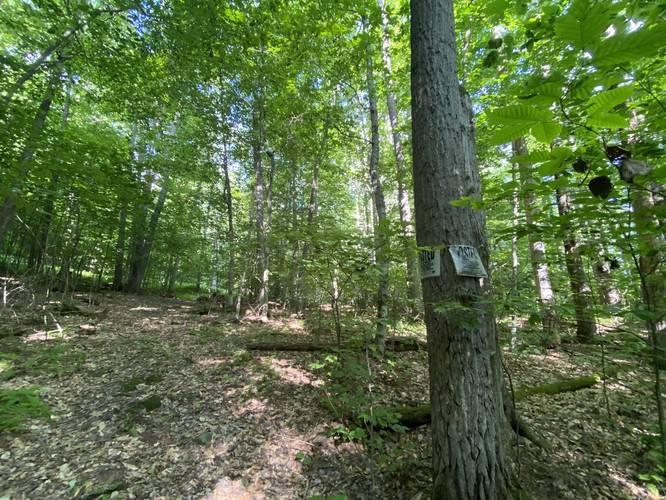
ATV Paths, Private Land, and State Forest Boundary - Mile 1.35 to 1.6
At mile 1.35 hikers will reach private land where, as of July 2022, only 2 posted signs were found on one tree which appeared to indicate the corner of a private property; however, this not a corner and rather a wall! At mile 1.35, once you see the posted signs, hikers will want to head due-south uphill through the forest and along the white blazes of the state forest boundary markers for approximately 0.1-miles. After 0.1-miles, take a right-hand turn (hiking in) to continue following the white blazes of the state forest boundary while heading due-west. Eventually, the trail will meet up with a wide path that cuts through the public land - this is your trail. Take a left-hand turn here to continue heading toward the Pine Island Vistas, heading southward. Note that if you miss the turn to follow the state forest boundary markers, hikers will end up on private property with many wide ATV paths that twist and turn. If you accidentally end up in this maze of private trails without knowing, it's easiest to turn around and retrace your steps to follow the state forest boundary markers along public land. Please respect the land owners and do not trespass.
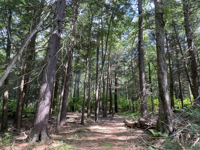
Old Growth Trees - Mile 2.42
A special find along this hike are the old growth eastern hemlock and white pine trees that can be found around mile 2.42. The trees can be found off-trail as well as directly on-trail too, so you don't have to go far to appreciate these old trees. Upon our hike here, I measured two trees - one white pine located 200-feet off-trail and one eastern hemlock located on-trail. The white pine measured in at 86.75 inch circumference / 27.62 inch D.b.h, which is about 138-years old, using this eastern white pine aging guide. The eastern hemlock measured in at 93 inch circumference / 75.2 cm D.b.h, which is about 190-years old using estimations from this USNF eastern hemlock aging guide.
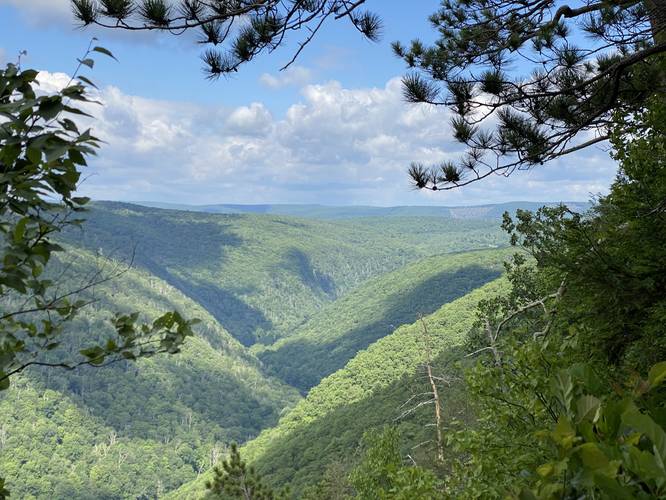
Pine Island Vista #1 - Mile 2.68
Finally, the trail will reach the first "Pine Island Vista" around mile 2.68. While not the best view along this hike, it's still a beautiful sight to see the Pine Creek Gorge after hiking for several miles to reach this spot.
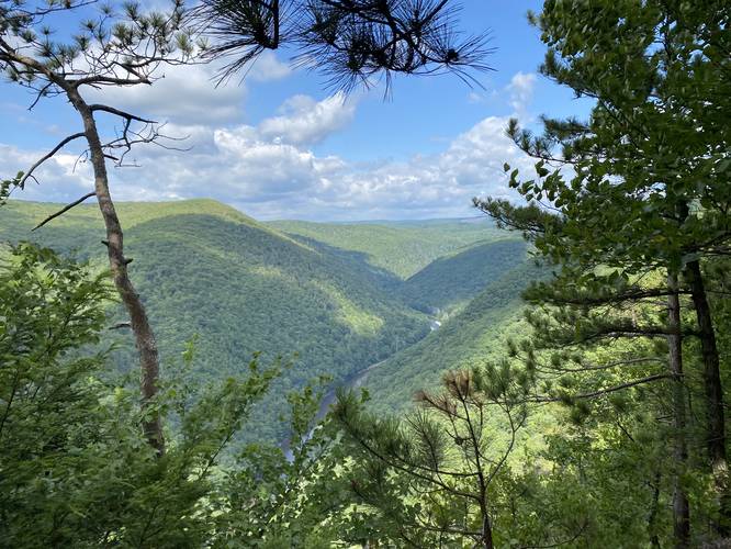
Pine Island Vista #2 - Mile 2.84
As the trail begins to head downhill along the edge of the canyon, hikers will reach another vista point around mile 2.84. This view includes views of both the canyon and Pine Creek, unlike the 1st vista.
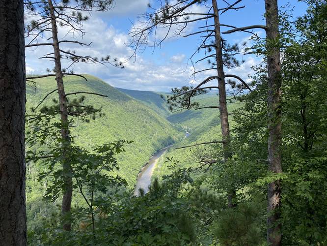
Pine Island Vista #3 - Mile 2.94
Just before reaching the best and final view along the trail, hikers will pass by one more vista - Pine Island Vista #3 which includes views of both the canyon and Pine Creek. This is located around mile 2.94.
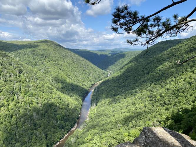
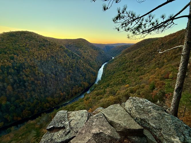
Pine Island Vista - Mile 2.96
Finally, hikers will reach a steeper section of the edge of the canyon as it drops just a bit further down to a beautiful rock outcropping that sits on the east rim of Pine Creek Gorge - Pine Island Vista, located around mile 2.96. The vista is the perfect spot to hang out and enjoy the canyon, eat lunch, or just take a break - but first, hikers should make sure that no Timber Rattlesnakes are hanging out in the brush nearby. The rock outcropping of Pine Island Vista gives ~180-degree views of the canyon with northwest-facing views. The cliff drop-off here appears to be about 900-feet down to the canyon floor; however, the closest tree tops, while less than 900-feet, are still likely hundreds of feet below - so staying back from the ledges is advised to enjoy the view without putting yourself at risk. Upon our hike here, we also noticed a peregrin falcon circling in the canyon. The peregrin falcon is also the world's fastest animal and was once endangered here. After a reintroduction in the 1990s, they now live in the canyon and are on their ~4th generation and there are only 3,000 mating pairs in the entire world. Hikers may also note a tower on the mountains in the distance - this is Cedar Mountain with three radio towers on its eastern summit along with Grand View located on its southeastern slopes.
Hiking Out
The hike out is obviously the opposite to the hike in, but there are some sections worth noting. Mainly if the hiker misses the state forest boundary turn you'll end up in ambiguous turns along the private land ATV paths and this can be tricky. So it's smart to track your location using an app so that way you can follow the same route that you took in. Additionally, the climb up from Pine Island Run is not easy - take your time as you ascend back to parking.
Parking
Hikers will find a small parking lot at the coordinates provided. It's large enough to fit about 3 vehicles.
Warnings
Rattlesnake territory: This hike leads out to several vista points that are generally made up of rocky outcroppings. Due to this, the Timber Rattlesnake calls this area home, and based on the number of sightings (and seeing one Timber Rattler on this hike) means that there's a nearby den. The rattlers will sun themselves on the rocks during high-noon between May and October, or be hiding in the brush just off-trail - or even on-trail. These snakes will even climb down the mountains to reach water sources down in the valleys during the Summer, so they could really be anywhere along this hike, but generally-speaking, you're bound to find a Timber Rattler near or at the vistas.
Remote hiking / no cell service: This hike has no cell service and is a remote hike pretty much right when you leave your vehicle. It's smart to always let someone know where you're going.
Filterable water: There's not a whole lot of places to get water along this trail, except for Pine Island Run. Once the hiker leaves Pine Island Run, there are no creeks to filter water from.
Steep cliffs: Once near the vistas, the trail follows along areas with steep cliffs. While the experienced hiker should be fine here - given plenty of room to stay away from the edges - it's smart to play it safe and don't hang off the edge or get too close to these cliffs as they can and do erode.
Wildlife
Upon our hike here during July 2022, we noticed several signs of wildlife including actual animals that weren't deer (the most common forest animal of Wellsboro, PA). Along the entire hike, we found numerous overturned rocks on the trail - a clear sign of black bear looking for food. The fresh bear scat was also another clear indication. There was a pile of what looked like owl scat and we also found a peregrin falcon circling the canyon in search of food. We found a black Timber Rattlesnake sunning itself on the far rocky outcropping at the final Pine Island Vista point. And last but not least, we found a porcupine along the trail too.
Hike Description
This hike begins at the trailhead for the Pine Island Trail and heads downhill following that same path for 0.68 miles as it leads through overgrown mountain laurel. Eventually, around mile 0.68, the trail will reach an old logging grade trail at a sharp angle. Here, take a right-hand turn to follow this logging grade for several-hundred feet, before beginning a short off-trail hike. From the old logging grade, hikers will bushwhack a bit down to Pine Island Run creek. Once at the creek, look for a campsite with wood piled nearby (look downstream).
Camp to Private Property Line - Mile 0.75 to 1.35
From mile 0.75, hikers will leave the campsite to then head up a large hill at a semi-steep grade for quite a while on what appears to be yet another old logging grade. Near the top of the hill, the trail will level-out slightly, but will also reach a boundary with private land - this part is a bit tricky to understand where to go without offline maps leading the way, so read below to make sure you stay on public land.
ATV Paths, Private Land, and State Forest Boundary - Mile 1.35 to 1.6
At mile 1.35 hikers will reach private land where, as of July 2022, only 2 posted signs were found on one tree which appeared to indicate the corner of a private property; however, this not a corner and rather a wall! At mile 1.35, once you see the posted signs, hikers will want to head due-south uphill through the forest and along the white blazes of the state forest boundary markers for approximately 0.1-miles. After 0.1-miles, take a right-hand turn (hiking in) to continue following the white blazes of the state forest boundary while heading due-west. Eventually, the trail will meet up with a wide path that cuts through the public land - this is your trail. Take a left-hand turn here to continue heading toward the Pine Island Vistas, heading southward. Note that if you miss the turn to follow the state forest boundary markers, hikers will end up on private property with many wide ATV paths that twist and turn. If you accidentally end up in this maze of private trails without knowing, it's easiest to turn around and retrace your steps to follow the state forest boundary markers along public land. Please respect the land owners and do not trespass.
Old Growth Trees - Mile 2.42
A special find along this hike are the old growth eastern hemlock and white pine trees that can be found around mile 2.42. The trees can be found off-trail as well as directly on-trail too, so you don't have to go far to appreciate these old trees. Upon our hike here, I measured two trees - one white pine located 200-feet off-trail and one eastern hemlock located on-trail. The white pine measured in at 86.75 inch circumference / 27.62 inch D.b.h, which is about 138-years old, using this eastern white pine aging guide. The eastern hemlock measured in at 93 inch circumference / 75.2 cm D.b.h, which is about 190-years old using estimations from this USNF eastern hemlock aging guide.
Pine Island Vista #1 - Mile 2.68
Finally, the trail will reach the first "Pine Island Vista" around mile 2.68. While not the best view along this hike, it's still a beautiful sight to see the Pine Creek Gorge after hiking for several miles to reach this spot.
Pine Island Vista #2 - Mile 2.84
As the trail begins to head downhill along the edge of the canyon, hikers will reach another vista point around mile 2.84. This view includes views of both the canyon and Pine Creek, unlike the 1st vista.
Pine Island Vista #3 - Mile 2.94
Just before reaching the best and final view along the trail, hikers will pass by one more vista - Pine Island Vista #3 which includes views of both the canyon and Pine Creek. This is located around mile 2.94.
Pine Island Vista - Mile 2.96
Finally, hikers will reach a steeper section of the edge of the canyon as it drops just a bit further down to a beautiful rock outcropping that sits on the east rim of Pine Creek Gorge - Pine Island Vista, located around mile 2.96. The vista is the perfect spot to hang out and enjoy the canyon, eat lunch, or just take a break - but first, hikers should make sure that no Timber Rattlesnakes are hanging out in the brush nearby. The rock outcropping of Pine Island Vista gives ~180-degree views of the canyon with northwest-facing views. The cliff drop-off here appears to be about 900-feet down to the canyon floor; however, the closest tree tops, while less than 900-feet, are still likely hundreds of feet below - so staying back from the ledges is advised to enjoy the view without putting yourself at risk. Upon our hike here, we also noticed a peregrin falcon circling in the canyon. The peregrin falcon is also the world's fastest animal and was once endangered here. After a reintroduction in the 1990s, they now live in the canyon and are on their ~4th generation and there are only 3,000 mating pairs in the entire world. Hikers may also note a tower on the mountains in the distance - this is Cedar Mountain with three radio towers on its eastern summit along with Grand View located on its southeastern slopes.
Hiking Out
The hike out is obviously the opposite to the hike in, but there are some sections worth noting. Mainly if the hiker misses the state forest boundary turn you'll end up in ambiguous turns along the private land ATV paths and this can be tricky. So it's smart to track your location using an app so that way you can follow the same route that you took in. Additionally, the climb up from Pine Island Run is not easy - take your time as you ascend back to parking.
Parking
Hikers will find a small parking lot at the coordinates provided. It's large enough to fit about 3 vehicles.
Warnings
Rattlesnake territory: This hike leads out to several vista points that are generally made up of rocky outcroppings. Due to this, the Timber Rattlesnake calls this area home, and based on the number of sightings (and seeing one Timber Rattler on this hike) means that there's a nearby den. The rattlers will sun themselves on the rocks during high-noon between May and October, or be hiding in the brush just off-trail - or even on-trail. These snakes will even climb down the mountains to reach water sources down in the valleys during the Summer, so they could really be anywhere along this hike, but generally-speaking, you're bound to find a Timber Rattler near or at the vistas.
Remote hiking / no cell service: This hike has no cell service and is a remote hike pretty much right when you leave your vehicle. It's smart to always let someone know where you're going.
Filterable water: There's not a whole lot of places to get water along this trail, except for Pine Island Run. Once the hiker leaves Pine Island Run, there are no creeks to filter water from.
Steep cliffs: Once near the vistas, the trail follows along areas with steep cliffs. While the experienced hiker should be fine here - given plenty of room to stay away from the edges - it's smart to play it safe and don't hang off the edge or get too close to these cliffs as they can and do erode.
Wildlife
Upon our hike here during July 2022, we noticed several signs of wildlife including actual animals that weren't deer (the most common forest animal of Wellsboro, PA). Along the entire hike, we found numerous overturned rocks on the trail - a clear sign of black bear looking for food. The fresh bear scat was also another clear indication. There was a pile of what looked like owl scat and we also found a peregrin falcon circling the canyon in search of food. We found a black Timber Rattlesnake sunning itself on the far rocky outcropping at the final Pine Island Vista point. And last but not least, we found a porcupine along the trail too.