Loading...

🎆 50% off 4th of July sale on Supporter Accounts — now through July 6! Learn More.

Yellow Birch Trail

Directions
Map
Pictures
Send to App
Distance:
0.6 Miles / 1.0 km
Type:
Loop
Difficulty:
Easy
Time to Hike:
~18 minutes
Features:
PA Wilds
Surface Type:
Dirt
Park:
Hills Creek State Park
Town:
Wellsboro, Pennsylvania
Directions:
41.81139, -77.194157
Added:
August 24, 2019
Updated:
March 15, 2024
Copy Trail Link Hiking this trail? Send a friend or family member a link to this trail guide for your own safety. Hike at your own risk (disclaimer)
Loading...
Loading...
70'

Total Change
75'

Ascent
88'

Descent

Download the Trail Route for Offline Use

Supporters get exclusive access to download trail routes to the MyHikes app for offline use. Stay prepared on your adventure, even without an internet connection! Become a Supporter today to unlock this feature and hike with confidence.

Send to App

Yellow Birch Trail

The Yellow Birch Trail at Hills Creek State Park near Wellsboro, Pennsylvania is an easy 0.6-mile loop trail that features views of Tauschers Pond and runs through a beautiful coniferous forest.

The trailhead for this trail can be found just east of the first camper campsite in the park, along Kelly's Swamp Road. The trail crosses a creek over a scenic wooden bridge before hitting a fork in the trail for the main loop.

This track heads left at the fork and follows the Yellow Birch Trail clockwise. The clockwise loop begins by heading uphill among coniferous trees along a well-maintained smooth dirt path. The trail meanders around a scenic pine grove before heading uphill to a bench where hikers can sit to rest. There's another creek below this resting point, just downhill from the bench.

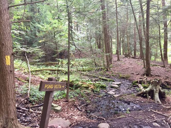
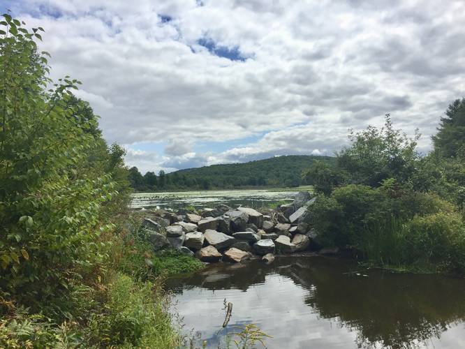
The trail then meanders further through the pine trees before reaching a sign labeled 'Pond Vista' - here, the trail heads down a short 0.1-mile long spur trail to a lookout point below Tauschers Pond. At the vista point, you get views of the hills across from Tauschers Pond - these hill are part of the Tauschers Loop Trail.

After visiting the Tauschers Pond vista point, the trail runs south to complete the loop for another 0.2-miles or so. If you plan to not hike to the vista point, the entire hike is between 0.4 and 0.5-miles total.

Pets: Dogs are allowed if leashed and their waste must be carried out by the hiker.

Biking: Biking is not allowed on this trail.
Explore 268 trails near Wellsboro, PA
  1. Parking

    41.81139, -77.194157
  2. Main Trailhead

    41.812284, -77.194755
  3. Spur trail to Tauschers Pond

    41.813439, -77.192589
    Spur trail to Tauschers Pond
  4. Tauschers Pond

    41.812497, -77.191794
    Tauschers Pond
No community routes found. To add your own hike as a Community Route for this Trail guide, leave a Trip Report with an attached GPX file.

Hazards

Ticks - Lyme Disease More Info (CDC)

Seasons

All

Blaze Color

Yellow

Photo Albums

Trip Reports

Trail Guide By:
Admin user profile picture
0.6 miles / 1.0 km
0.6 miles / 1.0 km
September 12, 2024
I grabbed a tree identification pamphlet from a stash right at the trailhead. Eleven trees along the trail were marked by numbered wooden posts. It was fun to reference the pamphlet and learn about the forest during the hike.
Hiking
0.6 miles / 1.0 km
August 24, 2019
Dogs Hiking

Weather Forecast

In Wellsboro, PA

Explore Hiking Trails

You May Also Like

Colorado's Million Dollar Highway - Plan a day's drive adventure along the iconic Million Dollar Highway in Colorado. Explore the best short trails, roadside stops, waterfalls, vistas, ghost towns, and hot springs within a ~6 hour road trip.
Explore

Colorado's Million Dollar Highway

Plan a day's drive adventure along the iconic Million Dollar Highway in Colorado. Explore the best short trails, roadside stops, waterfalls, vistas, ghost towns, and hot springs within a ~6 hour road trip.

Read
New York's Best Waterfalls - Whether you're planning a day hike, roadside stop, or a leisurely short walk, this guide provides hikers, travelers, and locals alike with 63 different locations to over 100 scenic waterfalls to help plan your next adventure!
Explore

New York's Best Waterfalls

Whether you're planning a day hike, roadside stop, or a leisurely short walk, this guide provides hikers, travelers, and locals alike with 63 different locations to over 100 scenic waterfalls to help plan your next adventure!

Read

Before you boogie...

Find our trail guides useful? Consider becoming a Supporter to unlock perks!

MyHikes is an indie platform that makes exploring public trails easier for everyone. The platform has no investors, no ads, and is owned and operated by one person, Dave Miller. Dave has personally mapped and written over 1,800 trail guides on MyHikes for the public to explore. MyHikes has helped millions outdoor enthusiasts plan their next adventure.

But it takes a lot of time 🕦, money 💰, work, and espresso shots ☕ to run MyHikes, including hiking , mapping , writing , and publishing new trails with high-quality (accurate) information... along with software engineering (coding) the platform like building new features, website and mobile app development (iOS and Android), site maintainance . and much much more.

Supporters unlock website and mobile app perks with an annual one-time payment of $25 (you renew) 😎👍. Or you can simply make a Donation of your choice. Otherwise, you can support us by telling your friends about MyHikes - both quick and free 🎉

Admin user profile picture

Dave Miller
MyHikes Founder