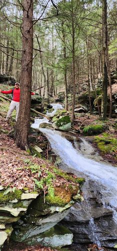
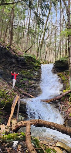
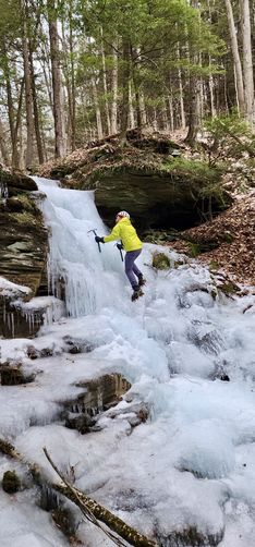
Upper Rattler Run Falls at Tioga State Forest in Morris, Pennsylvania is a difficult 1.9-mile out-and-back off-trail hike that features beautiful cascades and two prominent waterfalls, the largest being approximately 20 feet tall.
Trails
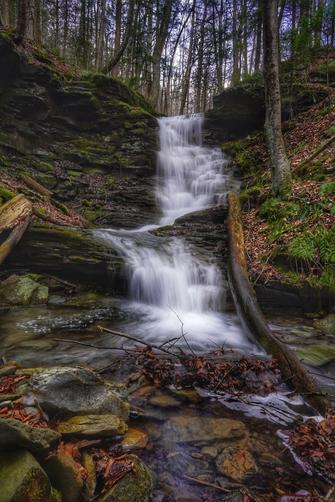
This hike does not follow any existing trails and follows Rattler Run from Rattler Road all the way down to reach PA Route 287 before heading back up Rattler Mountain. Note that this is a much-more difficult way to reach the cascades found in the lower section of the creek, Rattler Run Falls, however, includes some much larger waterfalls along the way.
Hike
This is a very difficult bushwhack. Technically you can hike this during any season. Realistically this should not be attempted in the winter months. Also, despite its lower elevation, your chances of encountering a rattlesnake on this hike are higher than I'd be comfortable with in the summer. This run is usually quite low and best enjoyed after days of hard rain. Keep in mind that the water is unfortunately polluted by acid-mine run off. Do not swim or drink the water.
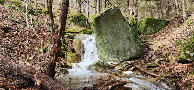
After parking at the Mid State Trail parking lot the run can be found about 50 feet down the road. Stay on the right side of the run for the entirety of the hike. You'll cross a tributary running into Rattler Run at mile ~0.1. This offers a very nice photo op. At mile 0.4 there is a large boulder next to a 3-foot cascade which provides another photo op. It seems easiest to stay pretty high up off the run from here until you get to Upper Rattler Run Falls. There is an old grade that you can find ~150 feet to the right of the run here that offers easy walking and a great view of the cascades.
Upper Rattler Run Falls - Mile 0.75
At around 0.65 miles you should see Upper Ratter Run Falls on your left. It is easiest to walk a bit further on the grade before descending and working your way back to view the falls. At 0.75 miles you will reach Upper Rattler Run Falls. Once you reach the last set of falls the right side of the run becomes private property, please do not trespass.
Optional Hike Back
If you'd rather road walk than climb back up the run, you can follow PA Route 287 for 0.6 miles south until you reach Rattler Road on your right, which will eventually return you to your vehicle. You can also opt to hit the Mid State Trail and check out Slide Hollow Falls making a nice loop hike. When you come to a fork in the trail with a registry you need to turn right, cross the run, and follow that trail all the way back. This option would add a few miles to your hike.
Parking
There is a large parking lot where the Mid State Trail crosses Rattler Road located on the right side of the road at the coordinates provided.
Camping & Backpacking
While there are no predefined campsites along this trail, Tioga State Forest does allow short-term primitive / dispersed / backcountry camping. If planning to setup camp, please follow all state forest rules and regulations.
Warnings
Off-trail hiking: This hike follows a run (creek) as it makes its way down Rattler Mountain; however, there's no defined hiking trail. Only experienced off-trail hikers should attempt this.
Timber Rattlesnakes: This area is home to the Timber Rattlesnake which can be found roaming the forest between the end of April and early October each year. If you find any rattlers, give them plenty of space.
Steep terrain: Some of the terrain surrounding Rattler Run can be steep, especially around the ~20-foot tall Upper Rattler Run Falls. Be mindful of the terrain and stay back from the edge of loose soil along very-steep slopes.
Private Property: At the bottom of the run, near PA-287 on the south side of the creek lies private property so you must hike through the creek to avoid trespassing.
Acid Mine Runoff: Do not swim in or drink/filter the water from this run as most of it comes from acid mine runoff either stemming directly out of the mountain and is always treated upstream with chemicals.
Trails
This hike does not follow any existing trails and follows Rattler Run from Rattler Road all the way down to reach PA Route 287 before heading back up Rattler Mountain. Note that this is a much-more difficult way to reach the cascades found in the lower section of the creek, Rattler Run Falls, however, includes some much larger waterfalls along the way.
Hike
This is a very difficult bushwhack. Technically you can hike this during any season. Realistically this should not be attempted in the winter months. Also, despite its lower elevation, your chances of encountering a rattlesnake on this hike are higher than I'd be comfortable with in the summer. This run is usually quite low and best enjoyed after days of hard rain. Keep in mind that the water is unfortunately polluted by acid-mine run off. Do not swim or drink the water.
After parking at the Mid State Trail parking lot the run can be found about 50 feet down the road. Stay on the right side of the run for the entirety of the hike. You'll cross a tributary running into Rattler Run at mile ~0.1. This offers a very nice photo op. At mile 0.4 there is a large boulder next to a 3-foot cascade which provides another photo op. It seems easiest to stay pretty high up off the run from here until you get to Upper Rattler Run Falls. There is an old grade that you can find ~150 feet to the right of the run here that offers easy walking and a great view of the cascades.
Upper Rattler Run Falls - Mile 0.75
At around 0.65 miles you should see Upper Ratter Run Falls on your left. It is easiest to walk a bit further on the grade before descending and working your way back to view the falls. At 0.75 miles you will reach Upper Rattler Run Falls. Once you reach the last set of falls the right side of the run becomes private property, please do not trespass.
Optional Hike Back
If you'd rather road walk than climb back up the run, you can follow PA Route 287 for 0.6 miles south until you reach Rattler Road on your right, which will eventually return you to your vehicle. You can also opt to hit the Mid State Trail and check out Slide Hollow Falls making a nice loop hike. When you come to a fork in the trail with a registry you need to turn right, cross the run, and follow that trail all the way back. This option would add a few miles to your hike.
Parking
There is a large parking lot where the Mid State Trail crosses Rattler Road located on the right side of the road at the coordinates provided.
Camping & Backpacking
While there are no predefined campsites along this trail, Tioga State Forest does allow short-term primitive / dispersed / backcountry camping. If planning to setup camp, please follow all state forest rules and regulations.
Warnings
Off-trail hiking: This hike follows a run (creek) as it makes its way down Rattler Mountain; however, there's no defined hiking trail. Only experienced off-trail hikers should attempt this.
Timber Rattlesnakes: This area is home to the Timber Rattlesnake which can be found roaming the forest between the end of April and early October each year. If you find any rattlers, give them plenty of space.
Steep terrain: Some of the terrain surrounding Rattler Run can be steep, especially around the ~20-foot tall Upper Rattler Run Falls. Be mindful of the terrain and stay back from the edge of loose soil along very-steep slopes.
Private Property: At the bottom of the run, near PA-287 on the south side of the creek lies private property so you must hike through the creek to avoid trespassing.
Acid Mine Runoff: Do not swim in or drink/filter the water from this run as most of it comes from acid mine runoff either stemming directly out of the mountain and is always treated upstream with chemicals.