The Slide Hollow Falls Loop at Tioga State Forest in Morris, Pennsylvania is a difficult 2.6-mile loop hike that features a scenic 12-foot waterfall named Slide Hollow Falls and also includes a stop at an old abandoned coal incline that was used from 1903 to 1909 by the Tioga Coal Company named the Rattler Incline.
Trails
This hike follows the Mid State Trail (MST - orange blazes), Slide Hollow Trail (yellow blazes), and Rattler Mine Road which is a wide dirt road that leads through the state forest.
Hike Description
This trek begins along Rattler Mine Rd in Morris, PA near the coordinates provided and heads south along the road for about 50-feet to reach the trailhead for the Mid State Trail (MST). Here, hikers will begin a short, but steep, uphill climb that eventually leads to an old log slide track that heads gradually back downhill through the forest. Eventually this old log slide will converge with yet another old log slide before reaching the old abandoned Rattler Incline.
Rattler Incline
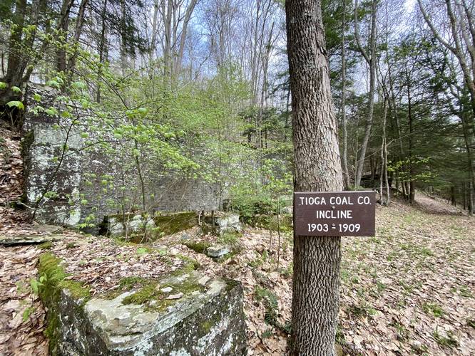
Around mile 0.6, hikers will reach the Rattler Incline - an old abandoned incline that was once used to transport coal down the mountain. This incline was only used for a short period of time because the quality and abundance of coal that was expected to be produced by the Rattler Mine did not live up to expectations. Additionally, the steam-powered incline did not operate as well as it was designed to and in 1909 the coal operation stopped, along with the incline. All that's left here today are the concrete and stone foundations that once held the incline.
Reaching the Slide Hollow Trail
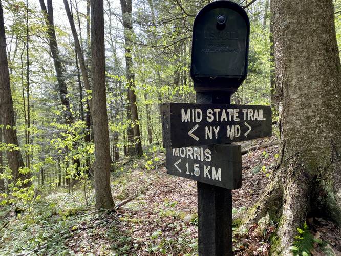
After visiting the Rattler Incline, the trail heads up and behind the incline along a small series of switchbacks before heading downhill for quite a ways. At the bottom of this steep hill are two creek crossings and just after the 2nd creek crossing lies the trailhead for the Slide Hollow Trail and a registry box for the Mid State Trail (MST), which sits around mile 1. Hikers should sign in at the MST registry box.
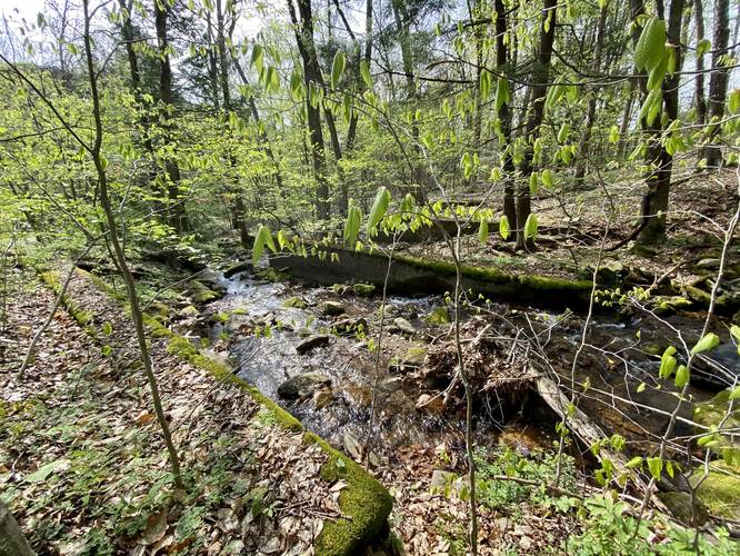
Reaching Slide Hollow Falls (approx 12-feet tall)
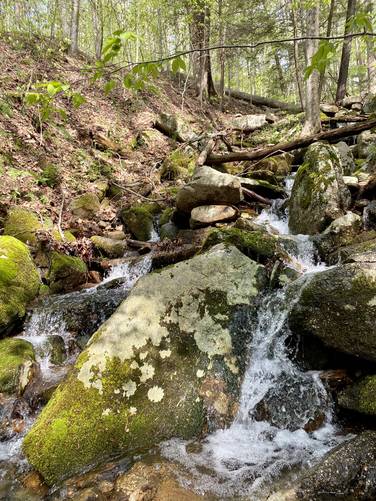
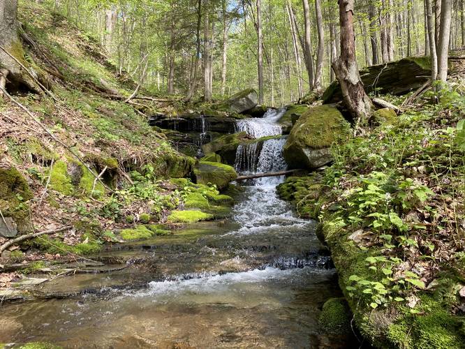
Hikers will then head downhill, following yellow blazes, along the Slide Hollow Trail which also appears to be an old log slide of sorts. Slide Hollow Run or Slide Hollow creek has several small waterfalls, between 2 and 3-feet tall, that cascade down the run; however, I did not photograph any of these as I was waiting to reach the main waterfall - Slide Hollow Falls. Hikers will finally reach Slide Hollow Falls around mile 1.45, just before the trail turns to cross the creek once again to avoid private properties. Here, hikers can backtrack up the creek about 50-feet to reach the base of the waterfall. Slide Hollow Falls is a multi-cascade waterfall that spills down two large boulders to create a ~12-foot tall waterfall.
Hiking Out
After visiting Slide Hollow Falls, hikers will head out along the yellow blazes to reach Rattler Mine Road once again. Before reaching the road, a keen-eyed hiker may notice more concrete foundations located in the creek and to the side of the creek just off-trail to the opposite side. These old foundations were used for the Rattler Incline where dump-loads of coal were unloaded into hoppers on a trestle that extended from this location, south, toward the present-day campground. A train would then pass through Landrus (passing Nessmuk's Winter Camp) and Arnot up through Blossburg and Mansfield before reaching NY state.
Hikers will then hike uphill along Rattler Mine Road to reach the parking area, which is approximately 1-mile from where the Slide Hollow Trail reaches the road.
Lazy-Person's Hike to reach Slide Hollow Falls
For the lazy adventurer - or someone who's short on time - if you can find a decent place to pull-off on Rattler Mine Road close to the Slide Hollow Trail, you can reach the waterfall within less than a 0.3-mile out-and-back hike.
Difficulty
This trail is considered "hard" because there are several steep sections of hill, along with a longer climb at the end. Some hikers may find this trek moderate, but it certainly is not an easy hike. If you visit Slide Hollow Falls without using the Mid State Trail at all - assuming an out-and-back hike - the hike difficulty is definitely easy.
Parking
Hikers will find parking at the coordinates provided where the Mid State Trail crosses Rattler Mine Road.
Pets
Dogs are allowed and they should be leashed.
Camping and Backpacking
Backpackers will find no campsites or any place to easily setup a camp along this trek; however, backpacking is allowed along the Mid State Trail and at Tioga State Forest. Please follow all rules and regulations when dispersed / primitive / backcountry camping.
Blaze Colors
This hike follows orange blazes (Mid State Trail) and yellow blazes (Slide Hollow Trail). The blazes end when the hiker reaches Rattler Mine Road, where the Slide Hollow Trail terminates.
Wildflowers
During the Spring, hikers may find Squirrel Corn and Trillium wildflower growing mostly within Slide Hollow. Along the Slide Hollow Trail in particular was a very large patch of Squirrel Corn wildflower during Spring 2021.
Trails
This hike follows the Mid State Trail (MST - orange blazes), Slide Hollow Trail (yellow blazes), and Rattler Mine Road which is a wide dirt road that leads through the state forest.
Hike Description
This trek begins along Rattler Mine Rd in Morris, PA near the coordinates provided and heads south along the road for about 50-feet to reach the trailhead for the Mid State Trail (MST). Here, hikers will begin a short, but steep, uphill climb that eventually leads to an old log slide track that heads gradually back downhill through the forest. Eventually this old log slide will converge with yet another old log slide before reaching the old abandoned Rattler Incline.
Rattler Incline
Around mile 0.6, hikers will reach the Rattler Incline - an old abandoned incline that was once used to transport coal down the mountain. This incline was only used for a short period of time because the quality and abundance of coal that was expected to be produced by the Rattler Mine did not live up to expectations. Additionally, the steam-powered incline did not operate as well as it was designed to and in 1909 the coal operation stopped, along with the incline. All that's left here today are the concrete and stone foundations that once held the incline.
Reaching the Slide Hollow Trail
After visiting the Rattler Incline, the trail heads up and behind the incline along a small series of switchbacks before heading downhill for quite a ways. At the bottom of this steep hill are two creek crossings and just after the 2nd creek crossing lies the trailhead for the Slide Hollow Trail and a registry box for the Mid State Trail (MST), which sits around mile 1. Hikers should sign in at the MST registry box.
Reaching Slide Hollow Falls (approx 12-feet tall)
Hikers will then head downhill, following yellow blazes, along the Slide Hollow Trail which also appears to be an old log slide of sorts. Slide Hollow Run or Slide Hollow creek has several small waterfalls, between 2 and 3-feet tall, that cascade down the run; however, I did not photograph any of these as I was waiting to reach the main waterfall - Slide Hollow Falls. Hikers will finally reach Slide Hollow Falls around mile 1.45, just before the trail turns to cross the creek once again to avoid private properties. Here, hikers can backtrack up the creek about 50-feet to reach the base of the waterfall. Slide Hollow Falls is a multi-cascade waterfall that spills down two large boulders to create a ~12-foot tall waterfall.
Hiking Out
After visiting Slide Hollow Falls, hikers will head out along the yellow blazes to reach Rattler Mine Road once again. Before reaching the road, a keen-eyed hiker may notice more concrete foundations located in the creek and to the side of the creek just off-trail to the opposite side. These old foundations were used for the Rattler Incline where dump-loads of coal were unloaded into hoppers on a trestle that extended from this location, south, toward the present-day campground. A train would then pass through Landrus (passing Nessmuk's Winter Camp) and Arnot up through Blossburg and Mansfield before reaching NY state.
Hikers will then hike uphill along Rattler Mine Road to reach the parking area, which is approximately 1-mile from where the Slide Hollow Trail reaches the road.
Lazy-Person's Hike to reach Slide Hollow Falls
For the lazy adventurer - or someone who's short on time - if you can find a decent place to pull-off on Rattler Mine Road close to the Slide Hollow Trail, you can reach the waterfall within less than a 0.3-mile out-and-back hike.
Difficulty
This trail is considered "hard" because there are several steep sections of hill, along with a longer climb at the end. Some hikers may find this trek moderate, but it certainly is not an easy hike. If you visit Slide Hollow Falls without using the Mid State Trail at all - assuming an out-and-back hike - the hike difficulty is definitely easy.
Parking
Hikers will find parking at the coordinates provided where the Mid State Trail crosses Rattler Mine Road.
Pets
Dogs are allowed and they should be leashed.
Camping and Backpacking
Backpackers will find no campsites or any place to easily setup a camp along this trek; however, backpacking is allowed along the Mid State Trail and at Tioga State Forest. Please follow all rules and regulations when dispersed / primitive / backcountry camping.
Blaze Colors
This hike follows orange blazes (Mid State Trail) and yellow blazes (Slide Hollow Trail). The blazes end when the hiker reaches Rattler Mine Road, where the Slide Hollow Trail terminates.
Wildflowers
During the Spring, hikers may find Squirrel Corn and Trillium wildflower growing mostly within Slide Hollow. Along the Slide Hollow Trail in particular was a very large patch of Squirrel Corn wildflower during Spring 2021.