The Turkey Path Trail at Colton Point State Park in Ansonia, Pennsylvania is a difficult 2.7-mile out-and-back hike down the Grand Canyon of Pennsylvania to the banks of Pine Creek and features a large scenic waterfall.
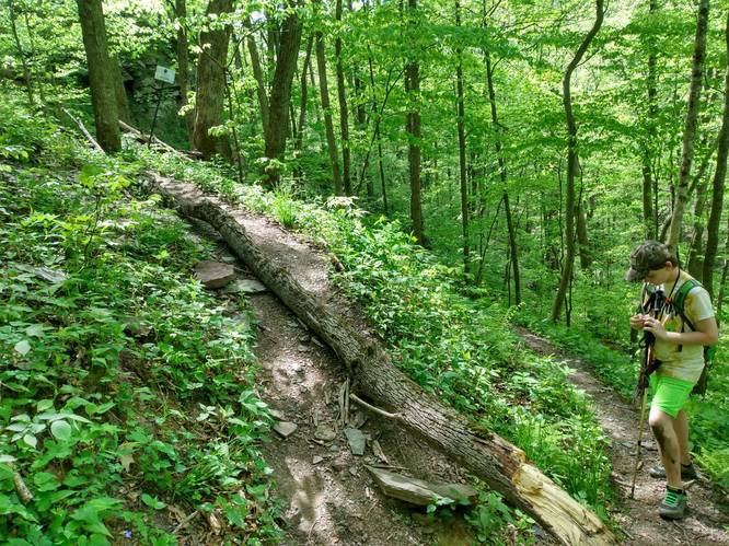
The entire hike itself is difficult due to the grade of the trail along with the rocks, roots, and skinny-width of the trail as it runs along very steep and tall hillsides. The trail winds downhill along switchbacks as it makes its way to the bottom of Pine Creek Gorge / the Grand Canyon of Pennsylvania, but is mostly secluded. If you're looking for a scenic hike near Wellsboro, Pennsylvania, check this trail out; however, if you only care about waterfalls, you're best bet is to hike back up after visiting the main falls.
Connecting to Leonard Harrison State Park
If you want a longer day-hike and don't mind crossing Pine Creek, you can plan to continue the hike along the Turkey Path Trail at Leonard Harrison State Park. You'll need to wade across Pine Creek, where the water can be over 1-foot deep; however depending on the time of year, the water is often not very strong, so the crossing is not too difficult. Most people end up hiking out-and-back along each side of the Turkey Path instead of crossing Pine Creek though.
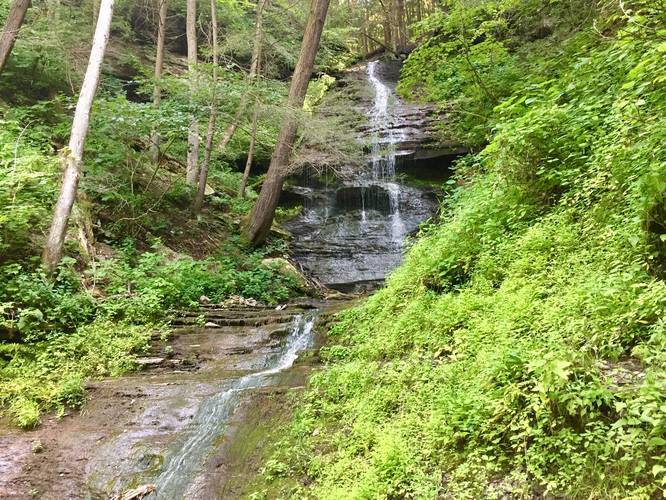
Waterfalls
This trail features a large waterfall, which cascades down into Pine Creek Gorge (PA Grand Canyon) roughly 50-feet within the main cascade. The first set of waterfalls can be found shortly after hiking down the first set of switchbacks - roughly a half-mile from the parking area. Here you can find a couple of small waterfalls that cascade downhill toward the main waterfall. If you hike downhill for another 0.1-mile or so, you'll find a spur trail that leads off of the main trail and heads to the base of the main waterfall that sits along the Rexford Branch Creek. Further into the hike (not shown in this trail map) is another waterfall that cascades down Fourmile Run, and the waterfall looks to be about 10-feet tall. There appears to be a spur trail that runs down into this area; however, that trail is not shown here - if you choose to go off-trail, bring a GPS tracker along with you.
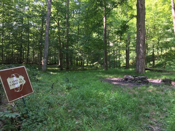
Camping
There's one campsite and a large fire ring located directly next to Pine Creek where the trail reaches the banks of the creek. There's enough room for a couple of tents. Please follow all state forest rules and regulations for primitive / backcountry / dispersed camping.
Parking
Parking can be found about 100-feet from the trailhead. The parking lot can fit about 10+ cars or so, but is often empty.
Pets
Dogs are allowed if leashed and their waste must be carried out by the hiker.
Warnings/Dangers
Steep terrain: This trail is quite the hike and worth a visit, but is very dangerous. Once you reach the switchback sections of the trail (just 0.2-miles into the hike), you'll be hiking along a very skinny and rocky trail that runs along steep hillsides. Some of these hillsides drop 50+ feet or more.
The trail runs along ledge areas where massive rocks have fallen and block the trail as well. Be sure to take your time, watch your footing, and stay away from the edge of the trail at all times - it doesn't take much to tumble down the hillside. Cellphone service out here is also scarce, so if you get hurt, you may have a very difficult time getting help.
Hunting: Hunting is also permitted below the main waterfall, so plan to wear blaze-orange to make sure you're visible when hiking.
Poison Ivy: Note that there's plenty of poison ivy growing along the trail during warmer months.
Rattlesnakes: While rare, the Timber Rattlesnake lives in this area and tends to come down to creeks to cool down or hunt between the end of April through the end of September. Watch your step and give any rattlesnake you see some space.
Blazes
Follow the blue blazes; however, they're very old and difficult to find. The main trail is very easy to follow though.
The entire hike itself is difficult due to the grade of the trail along with the rocks, roots, and skinny-width of the trail as it runs along very steep and tall hillsides. The trail winds downhill along switchbacks as it makes its way to the bottom of Pine Creek Gorge / the Grand Canyon of Pennsylvania, but is mostly secluded. If you're looking for a scenic hike near Wellsboro, Pennsylvania, check this trail out; however, if you only care about waterfalls, you're best bet is to hike back up after visiting the main falls.
Connecting to Leonard Harrison State Park
If you want a longer day-hike and don't mind crossing Pine Creek, you can plan to continue the hike along the Turkey Path Trail at Leonard Harrison State Park. You'll need to wade across Pine Creek, where the water can be over 1-foot deep; however depending on the time of year, the water is often not very strong, so the crossing is not too difficult. Most people end up hiking out-and-back along each side of the Turkey Path instead of crossing Pine Creek though.
Waterfalls
This trail features a large waterfall, which cascades down into Pine Creek Gorge (PA Grand Canyon) roughly 50-feet within the main cascade. The first set of waterfalls can be found shortly after hiking down the first set of switchbacks - roughly a half-mile from the parking area. Here you can find a couple of small waterfalls that cascade downhill toward the main waterfall. If you hike downhill for another 0.1-mile or so, you'll find a spur trail that leads off of the main trail and heads to the base of the main waterfall that sits along the Rexford Branch Creek. Further into the hike (not shown in this trail map) is another waterfall that cascades down Fourmile Run, and the waterfall looks to be about 10-feet tall. There appears to be a spur trail that runs down into this area; however, that trail is not shown here - if you choose to go off-trail, bring a GPS tracker along with you.
Camping
There's one campsite and a large fire ring located directly next to Pine Creek where the trail reaches the banks of the creek. There's enough room for a couple of tents. Please follow all state forest rules and regulations for primitive / backcountry / dispersed camping.
Parking
Parking can be found about 100-feet from the trailhead. The parking lot can fit about 10+ cars or so, but is often empty.
Pets
Dogs are allowed if leashed and their waste must be carried out by the hiker.
Warnings/Dangers
Steep terrain: This trail is quite the hike and worth a visit, but is very dangerous. Once you reach the switchback sections of the trail (just 0.2-miles into the hike), you'll be hiking along a very skinny and rocky trail that runs along steep hillsides. Some of these hillsides drop 50+ feet or more.
The trail runs along ledge areas where massive rocks have fallen and block the trail as well. Be sure to take your time, watch your footing, and stay away from the edge of the trail at all times - it doesn't take much to tumble down the hillside. Cellphone service out here is also scarce, so if you get hurt, you may have a very difficult time getting help.
Hunting: Hunting is also permitted below the main waterfall, so plan to wear blaze-orange to make sure you're visible when hiking.
Poison Ivy: Note that there's plenty of poison ivy growing along the trail during warmer months.
Rattlesnakes: While rare, the Timber Rattlesnake lives in this area and tends to come down to creeks to cool down or hunt between the end of April through the end of September. Watch your step and give any rattlesnake you see some space.
Blazes
Follow the blue blazes; however, they're very old and difficult to find. The main trail is very easy to follow though.