Loading...

Thunder Hole

Directions
Map
Pictures
Send to App
Distance:
0.1 Miles / 0.2 km
Type:
Out-and-Back
Difficulty:
Easy
Time to Hike:
~5 minutes
Features:
Surface Type:
Universal Access
Park:
Acadia National Park
Town:
Bar Harbor, Maine
Directions:
44.320892, -68.18931
Added:
May 14, 2025
Updated:
May 18, 2025
Copy Trail Link Hiking this trail? Send a friend or family member a link to this trail guide for your own safety. Hike at your own risk (disclaimer)
Loading...
Loading...
42'

Total Change
42'

Ascent
42'

Descent

Download the Trail Route for Offline Use

Supporters get exclusive access to download trail routes to the MyHikes app for offline use. Stay prepared on your adventure, even without an internet connection! Become a Supporter today to unlock this feature and hike with confidence.

Send to App

Thunder Hole

Thunder Hole at Acadia National Park near Bar Harbor, Maine is an easy 0.1-mile out-and-back walk that leads to a seaside chasm known as Thunder Hole.

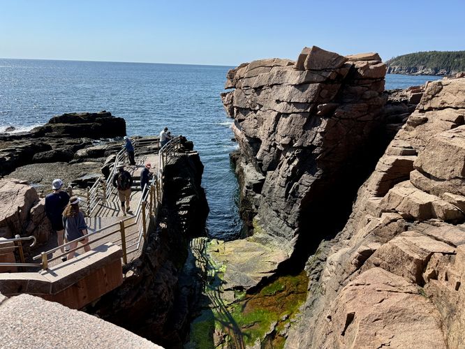
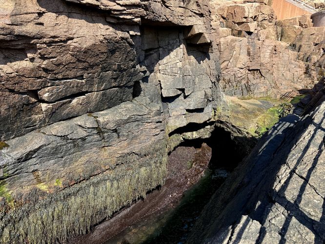
Exploring Thunder Hole

This short walk begins at the main parking area for Thunder Hole and leads down the staircases to reach the seaside chasm of Thunder Hole. The rock formation gets its name from the noise created during high tide when waves crash into the coastline. Over millennia, the ocean has eroded a channel, or chasm, in the rocky coastline and at the very back of the chasm is a tunnel. As the waves at high tide roll in, they crash into the chasm and create a noise similar to thunder. If you show up during low tide or in between tides, you'll likely miss the spectacle of both the noise and the scenery of the crashing waves. When we visited both times during low tide, the noise was essentially an echoed slosh in the chasm's tunnel.

For hikers exploring the Ocean Path, you'll be able to access Thunder Hole along the route.

Universal Access

Please note that Thunder Hole is technically universally-accessible. The route provided does not follow a universally-accessible path, but there's an ADA-compliant ramp that leads from the parking area down to a viewing area above thunder hole. Unfortunately the path that leads to the chasm's edge at sea level is not accessible.

Other Nearby Hikes

If you're planning to explore Thunder Hole, you can also consider hiking Gorham Mountain and the Cadillac Cliffs, The Beehive and The Bowl, or take a short stroll along the Ocean Path at Otter Point.

Parking

Visitors will find a large parking lot at the Thunder Hole parking area, at the coordinates provided. The lot is large enough to fit over 20 vehicles as of May 2025.

Pets

Dogs are allowed only if leashed and cleaned up after.
Explore 18 trails near Bar Harbor, ME
  1. Parking

    44.320892, -68.18931
  2. Main Trailhead

    44.320892, -68.18931
  3. Thunder Hole

    44.320753, -68.188644
    Thunder Hole
  4. Thunder Hole chasm and its tunnel

    44.320586, -68.188492
    Thunder Hole chasm and its tunnel
No community routes found. To add your own hike as a Community Route for this Trail guide, leave a Trip Report with an attached GPX file.

Hazards

Ticks - Lyme Disease More Info (CDC)
Rockfalls / Ledges / or Scrambles

Seasons

All

Photo Albums

Trip Reports

Trail Guide By:
Admin user profile picture
0.1 miles / 0.2 km
0.1 miles / 0.2 km
May 14, 2025
Not thundering at this time. It was a hole in a rock
Hiking

Weather Forecast

In Bar Harbor, ME

Explore Hiking Trails

You May Also Like

Colorado's Million Dollar Highway - Plan a day's drive adventure along the iconic Million Dollar Highway in Colorado. Explore the best short trails, roadside stops, waterfalls, vistas, ghost towns, and hot springs within a ~6 hour road trip.
Explore

Colorado's Million Dollar Highway

Plan a day's drive adventure along the iconic Million Dollar Highway in Colorado. Explore the best short trails, roadside stops, waterfalls, vistas, ghost towns, and hot springs within a ~6 hour road trip.

Read
Glacier's Going-to-the-Sun Road - Discover the breathtaking beauty of Glacier National Park along the iconic Going-to-the-Sun Road. From stunning roadside stops to picturesque waterfalls and vistas, this engineering marvel offers endless opportunities for exploration.
Explore

Glacier's Going-to-the-Sun Road

Discover the breathtaking beauty of Glacier National Park along the iconic Going-to-the-Sun Road. From stunning roadside stops to picturesque waterfalls and vistas, this engineering marvel offers endless opportunities for exploration.

Read
New York's Best Waterfalls - Whether you're planning a day hike, roadside stop, or a leisurely short walk, this guide provides hikers, travelers, and locals alike with 63 different locations to over 100 scenic waterfalls to help plan your next adventure!
Explore

New York's Best Waterfalls

Whether you're planning a day hike, roadside stop, or a leisurely short walk, this guide provides hikers, travelers, and locals alike with 63 different locations to over 100 scenic waterfalls to help plan your next adventure!

Read

Before you boogie...

Find our trail guides useful? Consider becoming a Supporter to unlock perks!

MyHikes is an indie platform that makes exploring public trails easier for everyone. The platform has no investors, no ads, and is owned and operated by one person, Dave Miller. Dave has personally mapped and written over 1,800 trail guides on MyHikes for the public to explore. MyHikes has helped millions outdoor enthusiasts plan their next adventure.

But it takes a lot of time ๐Ÿ•ฆ, money ๐Ÿ’ฐ, work, and espresso shots โ˜• to run MyHikes, including hiking , mapping , writing , and publishing new trails with high-quality (accurate) information... along with software engineering (coding) the platform like building new features, website and mobile app development (iOS and Android), site maintainance . and much much more.

Supporters unlock website and mobile app perks with an annual one-time payment of $25 (you renew) ๐Ÿ˜Ž๐Ÿ‘. Or you can simply make a Donation of your choice. Otherwise, you can support us by telling your friends about MyHikes - both quick and free ๐ŸŽ‰

Admin user profile picture

Dave Miller
MyHikes Founder