The Beehive and The Bowl hike at Acadia National Park near Bar Harbor, Maine is a strenuous 1.4-mile loop that features breathtaking panoramic views and includes climbing a steep vertical rock face via metal rungs.
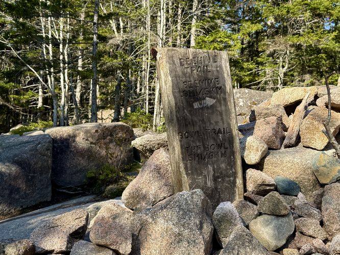
The hike begins at the main trailhead, located north of the parking lot for Sand Beach. The trail leads uphill as it follows a blue blazed path defined by scattered rocks and boulders. At mile 0.15, you'll come to the junction for The Beehive Trail (metal rung climbing route) where this route takes a right-hand turn at the sign. Hikers are reminded of the warnings and dangers along this trail by a large yellow sign. Read and understand the sign to understand your own risks -- then decide if you wish to continue. Do not bring your dog along this route!
If you continue, The Beehive Trail begins its ascent by following rock steps on the mountain's exposed rock face. The beginning of the ascent is very easy compared to the rest, so it can be a bit misleading at first.
Rocky terrain: Most of the paths below the cliffs of The Beehive are littered with rocks and boulders, so you have to pay attention to every step along the trail.
Climbing The Beehive Trail
The Beehive is one of Acadia's most-popular destination for thrill seekers. This route is not for the faint of heart and may be considered very dangerous depending on the conditions. Hikers will be turned to semi-rock climbers via metal rungs to ascend The Beehive's exposed southern rock slopes via The Beehive Trail. If you're petrified of heights, this route is not for you but it's still encouraged to hike an alternative route to the top for the same views!The hike begins at the main trailhead, located north of the parking lot for Sand Beach. The trail leads uphill as it follows a blue blazed path defined by scattered rocks and boulders. At mile 0.15, you'll come to the junction for The Beehive Trail (metal rung climbing route) where this route takes a right-hand turn at the sign. Hikers are reminded of the warnings and dangers along this trail by a large yellow sign. Read and understand the sign to understand your own risks -- then decide if you wish to continue. Do not bring your dog along this route!
If you continue, The Beehive Trail begins its ascent by following rock steps on the mountain's exposed rock face. The beginning of the ascent is very easy compared to the rest, so it can be a bit misleading at first.
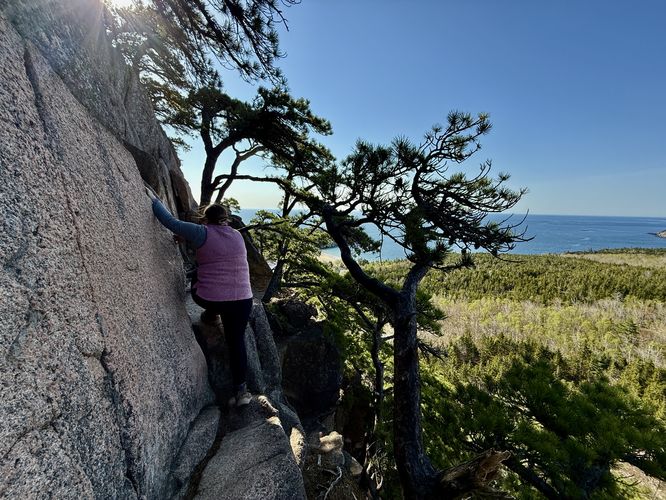
Metal Rung Climbing - Mile 0.23 to 0.3
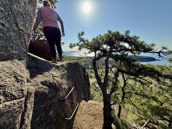
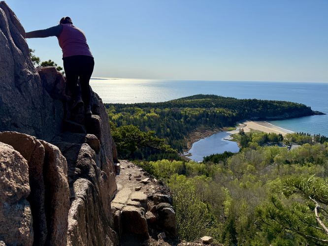
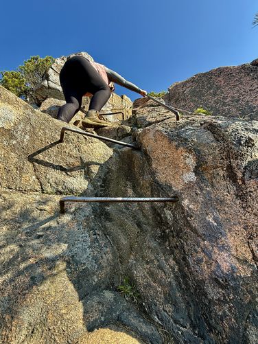
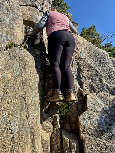
The section of The Beehive Trail that becomes "scary" and technically dangerous begins around mile 0.23 where you'll find a short rock scramble up to a cliff with a gap that's spanned by a metal grate. Watch your step as the grate can be slippery, especially when wet! You'll reach the first set of metal climbing rungs that sit along a steep cliff around mile 0.25 after following a couple of switchbacks up the mountain. This first set of rungs is easy as it's essentially just a large step. Along the next switchback are views of Gorham Mountain, Keif Pond, and Sand Beach which are a nice change of pace from staring at granite rock. Hold your breath and fear of heights though as this switchback leads along another very steep and tall cliff face as it follows a super-skinny path where, at the end, is a very large step/scramble to continue. Just beyond this sketchy cliff walk is another rock scramble that sits at one of the most-precarious sections of the climb. Just hang onto the rock and head upward. Immediately after this rock scramble is a set of metal rungs that leads up the steepest and longest section of rock. It's best to keep moving and focus on the rungs and rock as you'll be sending it up the scariest section of The Beehive's exposed cliffs. Follow another switchback and rock scramble up to the very-last metal rung climb with a ~10-foot tall pitch. Finally, you'll be done with the scary rock/rung climbing and scrambling around mile 0.3. The steep cliffs and panoramic views are not gone though, so just keep hiking up!Southern Views from The Beehive - Mile 0.35
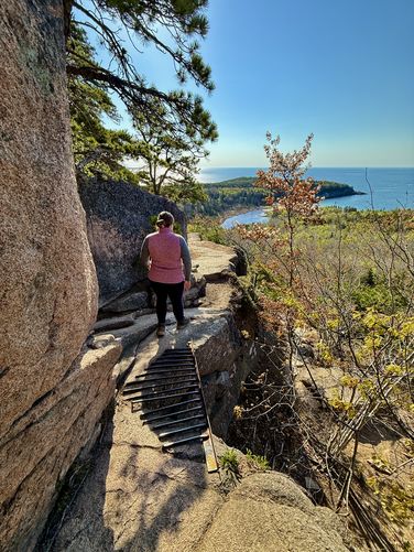
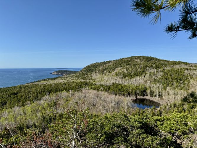
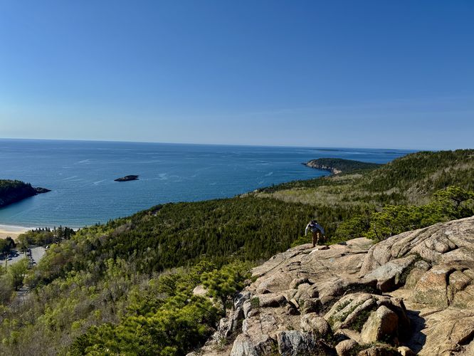
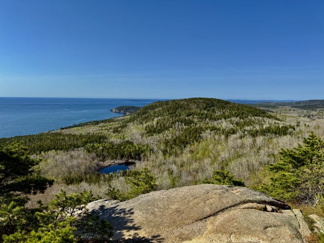
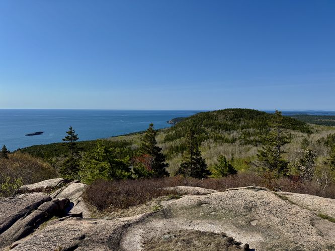
Once you're done with the steep rock scrambles and rock steps, hikers will reach a "flatter" section atop The Beehive around mile 0.35. Here, you can take-in the panoramic views that you worked so hard to reach. To the southeast sits Sand Beach and Great Head and to the southwest sits Gorham Mountain and Otter Point. This is a great spot to take a break and soak up the breathtaking views.Summit of The Beehive - Mile 0.4
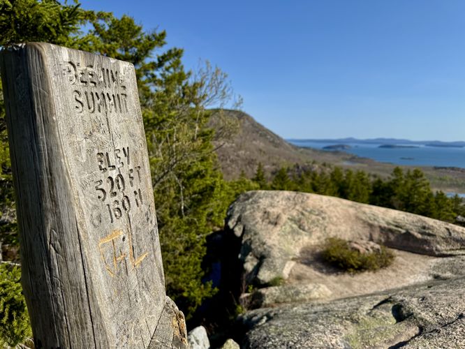
Once you're done relaxing from the climb up The Beehive, you can hike directly to the mountain's summit, located around mile 0.4. Here, you'll find more breathtaking panoramic views of Frenchman Bay with slopes of Enoch Mountain in the foreground.Hiking to The Bowl - Mile 0.4 to 0.77
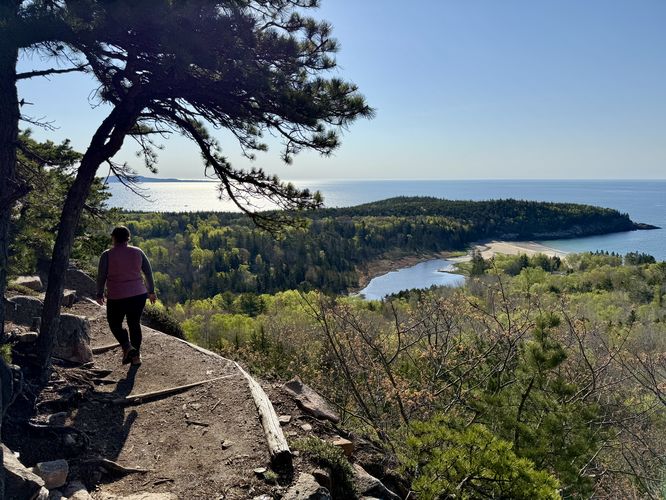
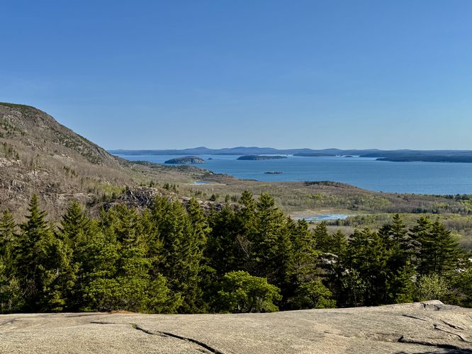
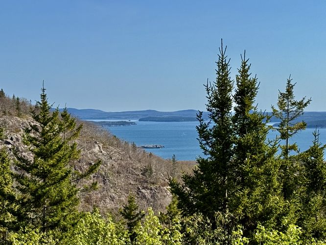
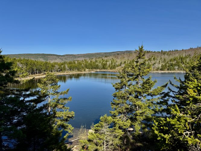
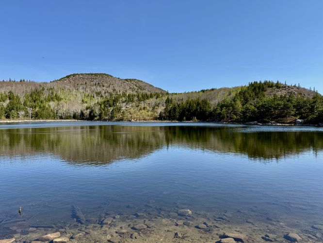
After you're done exploring the views from The Beehive's summit, this hike leads out to a mountain top pond called The Bowl. The trail from The Beehive to The Bowl is scenic and features several different views of some of Acadia's most prominent points-of-interest. Along the way, you'll find views of Keif Pond and Gorham Mountain once more around mile 0.48. Just up the trail around mile 0.57 are more views of the same, but you'll also find views of The Beehive's western slopes as well. Around mile 0.6 are more views toward Frenchman Bay, the islands within it, and Enoch Mountain. Finally, hikers will reach views of The Bowl at mile 0.7. The trail dips down to follow bedrock along the pond before reaching a viewpoint of The Bowl and Champlain Mountain at mile 0.77. Stick around to enjoy the views and have a snack or follow this route back to parking next.The Bowl to Parking - Mile 0.77 to 1.4
The last leg of the hike leads from The Bowl back to parking. This is mostly downhill, minus the short uphill section from the pond to start. Follow the signage to parking and pass Keif Pond along the way. This forested section of the hike is fairly boring, but engaging as it follows large rocks and boulders that define the trail so you have to pay attention to where you step. Finally, the hike ends at mile 1.4.Popularity
The Beehive and traversing its cliffs is one of Acadia National Park's most-popular destinations for hikers looking for stunning views and a different experience in nature. Due to this and its reputation for being dangerous, it's become a very-popular place for visitors to explore. If you wish to explore The Beehive and its cliffs in solitude, like we did, show up early in the morning (off-season helps) to ensure you get on the trail before everyone else. We personally climbed The Beehive with just one other hiker behind us who gave us plenty of space. We sat at the top for at least 10 minutes after and did not see anyone else. As we hiked out, we passed dozens of people hiking in.Difficulty
The difficulty rating on this hike should be considered strenuous, but not necessarily due to the physical difficulty. You hav to hike along very steep cliffs with sheer drops, climb metal rungs, and rock scramble up ~400-vertical feet. Additionally, you need to have the mental strength to push yourself up the mountain despite all of this. Due to the increased danger and risk along with the physical demand, the hike should be considered strenuous. Hiking the rest of the trails to complete the loop should be considered moderate.Parking
Hikers will find two parking lots for this hike but the coordinates provided will bring you to the massive parking lot for Sand Beach, located across the street. We showed up super early and parked at the "closer" parking lot just south of the Sand Beach lot. Show up early to ensure you can find parking as both lots fill up quickly.Pets
Dogs are not allowed along the cliff climb section of this loop. Dogs are allowed only if leashed and cleaned up after, along the other trails including the paths that lead to the summit of The Beehive.Warning
Cliffs and rung climbing: This hike leads along sections of trail that follow steep cliffs with sheer drops. Some sections of the trail include scrambling on rocks aside cliffs. Other sections of the trail include metal rungs for climbing. This trail is not for people who are afraid of heights. Do not hike this trail when it's wet, raining, or if the cliffs are wet. People have fallen and died on this trail or have suffered serious injuries from falling.Rocky terrain: Most of the paths below the cliffs of The Beehive are littered with rocks and boulders, so you have to pay attention to every step along the trail.