Loading...

🎉 Enjoy a Free 7-Day Supporter Trial and Unlock Exclusive Perks — No Credit Card Required. Learn more.

Ocean Path (Gorham Mtn to Sand Beach)

Directions
Map
Pictures
Send to App
Distance:
2.4 Miles / 3.9 km
Type:
Out-and-Back
Difficulty:
Easy
Time to Hike:
1 hour, ~12 minutes
Features:
Surface Type:
Dirt
Park:
Acadia National Park
Town:
Bar Harbor, Maine
Directions:
44.317059, -68.191186
Added:
May 15, 2025
Updated:
May 18, 2025
Copy Trail Link Hiking this trail? Send a friend or family member a link to this trail guide for your own safety. Hike at your own risk (disclaimer)
Loading...
Loading...
107'

Total Change
235'

Ascent
237'

Descent

Download the Trail Route for Offline Use

Supporters get exclusive access to download trail routes to the MyHikes app for offline use. Stay prepared on your adventure, even without an internet connection! Become a Supporter today to unlock this feature and hike with confidence.

Send to App

Ocean Path (Gorham Mtn to Sand Beach)

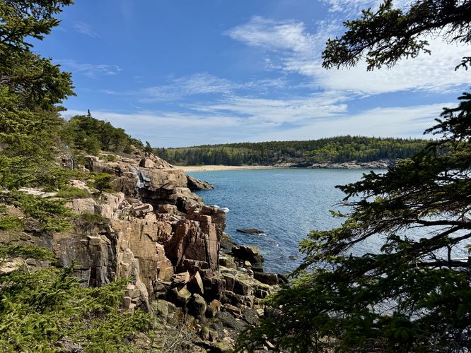
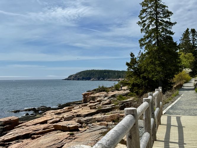
This section of the Ocean Path at Acadia National Park near Bar Harbor, Maine is an easy 2.4-mile out-and-back hike that runs from Gorham Mountain to Sand Beach and back and features breathtaking views of Maine's rocky coastline.

Hiking the Ocean Path

Acadia's Ocean Path is one of the most-popular and scenic day hikes that the park has to offer and for obvious reasons — this easy trail has something for everyone and can be accessed from various points along Park Loop Road. Sand Beach is especially popular with tourists during the summer as it offers a way for visitors to cool off from the heat. Off-season, the beach is still a popular place to walk around to enjoy scenery. This route is an out-and-back hike along Ocean Path starting at the Gorham Mountain parking area with a turn-around at Sand Beach.

Monument Cove - Mile 0 to 0.1

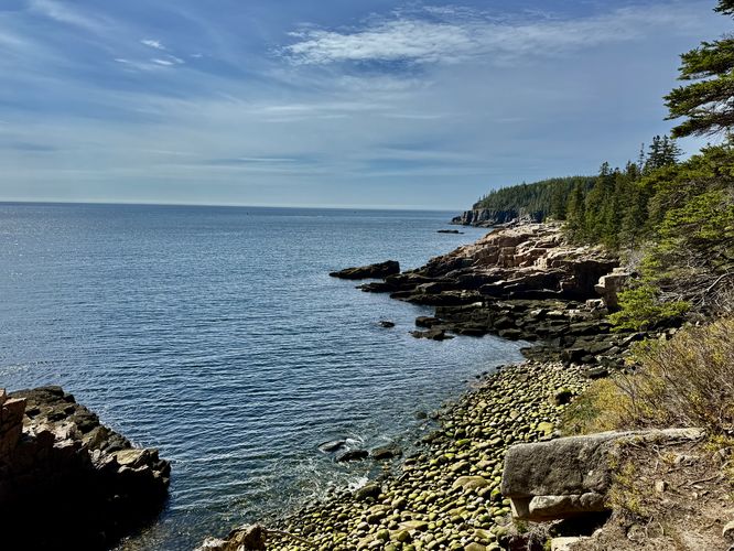
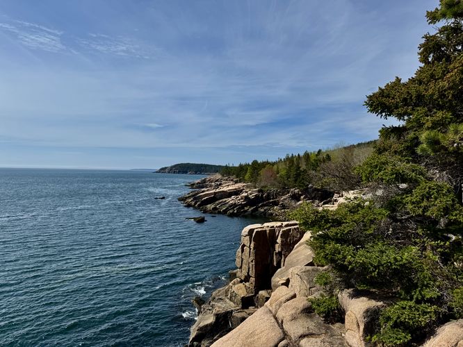
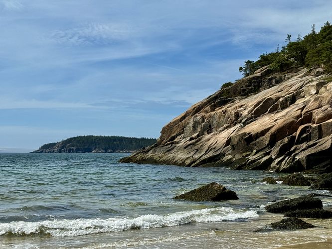
The hike begins by crossing the street from parking to reach the Ocean Path where visitors will find themselves on the southwest side of Monument Cove. Obstructed views can be found here, but the Ocean Path will eventually wrap around Monument Cove to provide several lookout points where you'll find views of Maine's rocky coastline along with the Otter Cliffs in the distance.

Just beyond Monument Cove lies a nice off-trail coastal outcropping where hikers can venture out onto for more views or to escape the crowds a bit. To get there, hike north from Monument Cove and take the next right-hand turn path that leads out to the rocky coastline. Just watch your step as the boulders in the path are uneven.

Thunder Hole - Mile 0.38

Up the trail further is the point-of-interest known as Thunder Hole. Thunder Hole is a rock channel or chasm with a tunnel in the rocky coastline that the ocean has eroded over millennia. During high tide only, you'll find the ocean's waves rushing through the channel and into the tunnel, then shooting high into the sky as it makes a thunderous noise in the process, hence the name. If you show up during low tide, like we did both times, then Thunder Hole is just another scenic off-shoot along the Ocean Path.

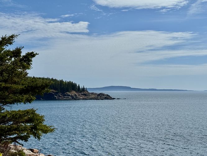
Schoodic Head Views - Mile 0.6

Around mile 0.6, hikers will find more views of Sand Beach and its cove adjacent to Great Head. Off in the distance, however, is the mountain known as Schoodic Head located across the sound.

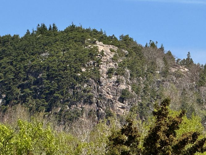
The Beehive Cliff Views - Mile 0.68

If you've climbed The Beehive before, this view will be a nice find along the way. Near mile 0.68 are views of The Beehive's cliffs. If you're lucky, have good eyesight, or a solid zoom on your camera or phone, you can probably spot people climbing the southern rock face of the mountain.

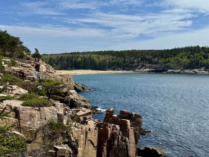
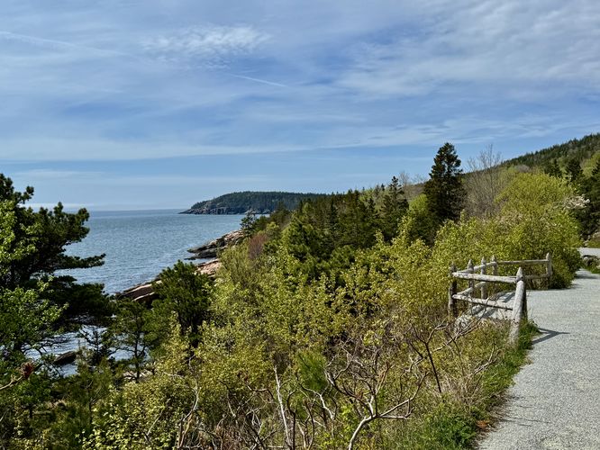
Sand Beach Views - Mile 0.8 to 1

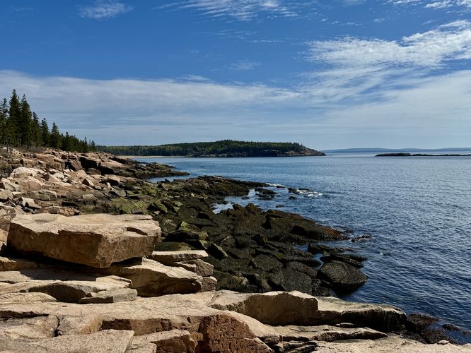
From mile 0.8 to 1 are several views of Sand Beach and the Great Head peninsula. Some of these views are directly on the trail while others sit just off-trail and are located down scenic paths. Each of these locations provide views to the south as well and mostly include views of the Otter Cliffs and the rocky coastline. Our favorite view along this hike was near mile 1, just above Sand Beach along the light-colored bedrock. The views of the water from the last high viewpoint were top-notch.

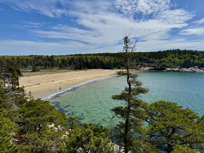
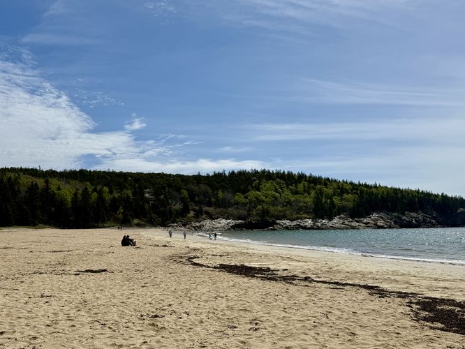
Exploring Sand Beach - Mile 1.3

The last leg of this hike leads through the forest, passing a parking lot for The Beehive, and leads down to the shores of Sand Beach. Along the way, you'll find restrooms and signage to point the way. Take the staircase down to Sand Beach and enjoy the views of the ocean and Maine's rocky coastline. On our hike, we split ways at the vista at mile 1, so we waved to each other from each location. I then hiked back up and we hiked back to parking.

Hiking Out - Mile 1.3 to 2.4

Taking the same, but opposite, route back to parking is just as scenic as the hike in albeit probably a bit quicker. Along the way you can hit some of the off-trail views you meant to explore on the way in to escape the crowds a bit or simply enjoy views from the Ocean Path itself. Arrive at parking at mile 2.4 to complete this easy hike along one of Maine's most iconic shorelines.

Other Nearby Hikes 

If you're planning to hike this section of the Ocean Path, you can also consider hiking Gorham Mountain and the Cadillac Cliffs, The Beehive and The Bowl, or take a short stroll along the Ocean Path at Otter Point. Our original plan was to hike The Beehive and The Bowl, hike to the summit of Gorham Mountain, and then hike back via this route along the Ocean Path but we decided to hike them piecemeal on different days which was virtually the same but felt like three different experiences. Regardless, hiking all three provides a really neat perspective of the landscape along this part of Acadia National Park and all three hikes are highly recommended.

Parking

Visitors will find many different parking lots to explore and hike the Ocean Path. This guide starts you at the Gorham Mountain parking lot, which is much smaller than other parking lots nearby, like the Sand Beach parking lot. This parking lot is large enough to fit about 20 vehicles or less as of May 2025.

Pets

Dogs are allowed only if leashed and cleaned up after.
Explore 18 trails near Bar Harbor, ME
  1. Parking

    44.317059, -68.191186
  2. Main Trailhead

    44.317059, -68.191186
  3. View of Monument Cove

    44.318222, -68.190842
    View of Monument Cove
  4. View of Great Head and Sand Beach from the rocky coast

    44.318536, -68.18975
    View of Great Head and Sand Beach from the rocky coast
  5. Views of Schoodic Head mountain on the horizon

    44.323356, -68.187103
    Views of Schoodic Head mountain on the horizon
  6. View of the vertical rock trail on The Beehive from the Ocean Path

    44.324481, -68.186706
    View of the vertical rock trail on The Beehive from the Ocean Path
  7. View of Sand Beach and the rocky coastline

    44.326197, -68.186156
    View of Sand Beach and the rocky coastline
  8. More views of Sand Beach and the rocky coastline

    44.326272, -68.186189
    More views of Sand Beach and the rocky coastline
  9. Distant views of the Otter Cliffs and Maine's rocky coastline

    44.327264, -68.185044
    Distant views of the Otter Cliffs and Maine's rocky coastline
  10. Turquoise waters of Sand Beach as seen from above

    44.328081, -68.184531
    Turquoise waters of Sand Beach as seen from above
  11. Restrooms

    44.329739, -68.184564
    Restrooms
  12. View of the coast from Sand Beach

    44.328906, -68.183608
    View of the coast from Sand Beach
  13. Sand Beach

    44.329139, -68.183539
    Sand Beach
  14. Ocean Path with views of Otter Cliffs in the distance

    44.327356, -68.185517
    Ocean Path with views of Otter Cliffs in the distance
  15. More views of the Otter Cliffs with the Ocean Path in view

    44.323228, -68.187194
    More views of the Otter Cliffs with the Ocean Path in view
No community routes found. To add your own hike as a Community Route for this Trail guide, leave a Trip Report with an attached GPX file.

Hazards

Ticks - Lyme Disease More Info (CDC)
Poison Ivy/Oak
Rockfalls / Ledges / or Scrambles

Seasons

All

Trip Reports

Trail Guide By:
Admin user profile picture
2.4 miles / 3.9 km
2.4 miles / 3.9 km
May 15, 2025
Nice walk with views and seclusion off of the main path
Hiking

Weather Forecast

In Bar Harbor, ME

Explore Hiking Trails

You May Also Like

Colorado's Million Dollar Highway - Plan a day's drive adventure along the iconic Million Dollar Highway in Colorado. Explore the best short trails, roadside stops, waterfalls, vistas, ghost towns, and hot springs within a ~6 hour road trip.
Explore

Colorado's Million Dollar Highway

Plan a day's drive adventure along the iconic Million Dollar Highway in Colorado. Explore the best short trails, roadside stops, waterfalls, vistas, ghost towns, and hot springs within a ~6 hour road trip.

Read
Glacier's Going-to-the-Sun Road - Discover the breathtaking beauty of Glacier National Park along the iconic Going-to-the-Sun Road. From stunning roadside stops to picturesque waterfalls and vistas, this engineering marvel offers endless opportunities for exploration.
Explore

Glacier's Going-to-the-Sun Road

Discover the breathtaking beauty of Glacier National Park along the iconic Going-to-the-Sun Road. From stunning roadside stops to picturesque waterfalls and vistas, this engineering marvel offers endless opportunities for exploration.

Read
New York's Best Waterfalls - Whether you're planning a day hike, roadside stop, or a leisurely short walk, this guide provides hikers, travelers, and locals alike with 63 different locations to over 100 scenic waterfalls to help plan your next adventure!
Explore

New York's Best Waterfalls

Whether you're planning a day hike, roadside stop, or a leisurely short walk, this guide provides hikers, travelers, and locals alike with 63 different locations to over 100 scenic waterfalls to help plan your next adventure!

Read

Before you boogie...

Find our trail guides useful? Consider becoming a Supporter to unlock perks!

MyHikes is an indie platform that makes exploring public trails easier for everyone. The platform has no investors, no ads, and is owned and operated by one person, Dave Miller. Dave has personally mapped and written over 1,800 trail guides on MyHikes for the public to explore. MyHikes has helped millions outdoor enthusiasts plan their next adventure.

But it takes a lot of time 🕦, money 💰, work, and espresso shots ☕ to run MyHikes, including hiking , mapping , writing , and publishing new trails with high-quality (accurate) information... along with software engineering (coding) the platform like building new features, website and mobile app development (iOS and Android), site maintainance . and much much more.

Supporters unlock website and mobile app perks with an annual one-time payment of $25 (you renew) 😎👍. Or you can simply make a Donation of your choice. Otherwise, you can support us by telling your friends about MyHikes - both quick and free 🎉

Admin user profile picture

Dave Miller
MyHikes Founder