Loading...

๐ŸŒฒ WINTER SALE! 50% OFF on Supporter Accounts โ€” now through December 31st. Unlock a full year of exclusive website & app perks for better hikes. Learn More.

Swiss National Park Nature Hike

Directions
Map
Pictures
Download Swiss National Park Nature Hike GPX Data to the MyHikes Mobile App
Distance:
1.3 km / 0.8 Miles
Type:
Out-and-Back
Difficulty:
Easy
Time to Hike:
~24 minutes
Features:
Surface Type:
Dirt
Town:
Zernez, Switzerland
Get Directions:
46.661009, 10.22944
Added:
September 26, 2025
Updated:
November 24, 2025
Copy Trail Link Hiking this trail? Send a friend or family member a link to this trail guide for your own safety. Hike at your own risk (disclaimer)
Loading...
Loading...
21m

Total Change
28m

Ascent
30m

Descent

Download the GPX Data for Offline Use

Supporters get exclusive access to download trail routes to the MyHikes app for offline use. Stay prepared on your adventure, even without an internet connection! Become a Supporter today to unlock this feature and hike with confidence.

Download Swiss National Park Nature Hike GPX Data to the MyHikes Mobile App

Key Takeaways

  • Experience the evergreen forest and snow-melt stream crossing leading to the mouth of Val dal Botsch, offering a quick, gentle ascent and majestic alpine peaks backdrop in Switzerland's oldest National Park.
  • Quick Swiss National Park Hike for Road Trips: Ideal 0.8-mile (1.3 km) leg-stretch hike located directly off Via Pass dal Fuorn (Ofenpassstrasse) near P8, perfect for travelers on a Swiss Alps road trip seeking a brief, high-impact nature immersion.
  • A well-maintained, easy out-and-back trail that provides soft footing and a secluded atmosphere, starting conveniently from Parking Area P8 for a hassle-free stop in the Swiss National Park.

Swiss National Park Nature Hike

This short, family-friendly out-and-back 1.3 km (0.8 mile) hike offers a perfect leg-stretcher and a quick immersion into the pristine wilderness of Swiss National Park, Switzerland's oldest and most treasured national park. Located right off the scenic Via Pass dal Fuorn (Ofenpassstrasse), this hike is an essential stop for anyone on a Swiss Alps road trip seeking a taste of alpine solitude.

Trail Guide: Val dal Botsch Short Hike (Swiss National Park)

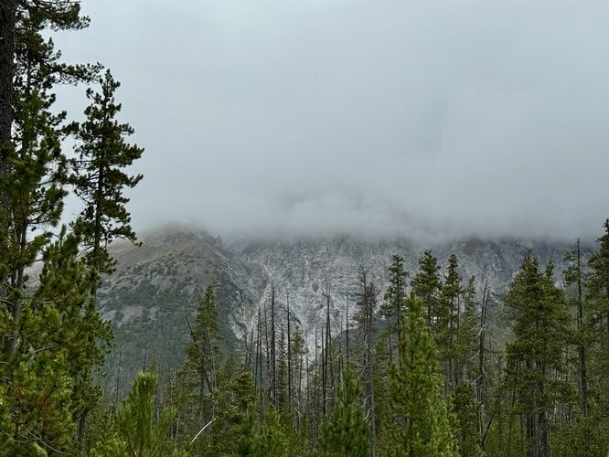
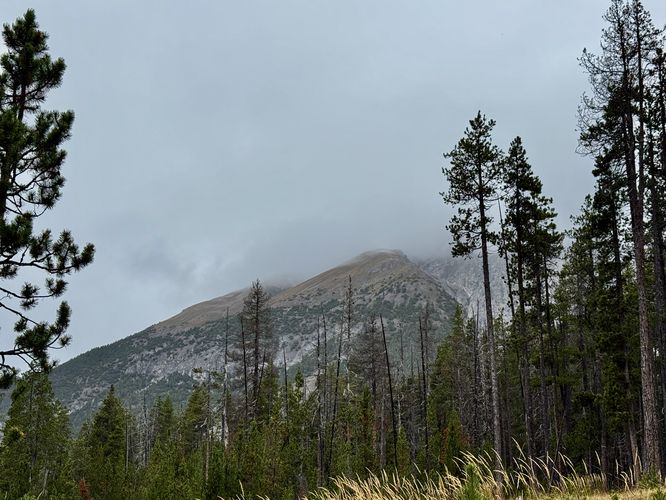
The hike begins just across the road from Parking Area P8 on the north side of the Via Pass dal Fuorn. The initial stretch of the trail leads you westward into a serene, fragrant evergreen forest. You will immediately be surrounded by towering conifers. While the dense canopy occasionally obscures the massive peaks above, the path offers a quiet, shaded environment perfect for slowing down and listening for the sounds of the forest. The trail is well-maintained and provides soft footing, ideal for travelers looking for a short, but secluded forest hike.

About 0.24 km from the trailhead, through the forest section, the trail crosses a tributary stream over a sturdy wooden footbridge. This stream is fed by seasonal snow-melt from the surrounding mountains, often featuring refreshingly clear, cold waterโ€”a true sign of the park's untouched nature. This is a great spot to pause, take a deep breath, and appreciate the sound of running water or take in the views of the towering alpine peaks.

Ascent into Val dal Botsch

After crossing the bridge, the trail continues westward, passing through more evergreens. Near 0.55 km, the path curves sharply to the north. Here, you will need to carefully cross the Via Pass dal Fuorn (be mindful of traffic) to pick up the trail on the opposite side. From here, the trail begins a short, gentle ascent into the mouth of Val dal Botsch. This route ends shortly after the initial ascent, marking a natural turnaround point before returning the way you came. For hikers with more time, at the top of the Val dal Botsch trail sits a majestic view of Swiss National Park, worthy of a longer day hike. Unfortunately for us, we did not have enough time on our road trip for any further exploration so we turned back here. If you plan to follow this route, the hike back to parking is easy - simply head back the way you came to wrap up this 1.3 km (0.8 mile) out-and-back nature hike through Swiss National Park!

Parking & Directions: How to Get to Swiss National Park

Visitors to Swiss National Park will find the main road, Via Pass dal Furon, cuts through the heart of the park. At the coordinates provided (46.661009, 10.22944), near P8, you'll find two parking lots on either side of the road. Each parking lot can accommodate approximately 20 vehicles each.

Pets

Dogs are not allowed on trails at Swiss National Park as of September 2025. Please check the park's rules and regulations before planning a hike here.
Explore 8 trails near Zernez, Switzerland
  1. Parking

    46.661009, 10.22944
  2. Main Trailhead

    46.661009, 10.22944
  3. More alpine mountain views from the trail in Swiss National Park

    46.660822, 10.229069
    More alpine mountain views from the trail in Swiss National Park
  4. View of the alpine mountains that surround Swiss National Park

    46.661172, 10.225386
    View of the alpine mountains that surround Swiss National Park
No community routes found. To add your own hike as a Community Route for this Trail guide, leave a Trip Report with an attached GPX file.

Seasons

All

Photo Albums

+ Add Photo Album

Upload your photos from the trail to help others know what to expect.

Preview of the MyHikes mobile app interface

Track, Log, and Explore Hikes with the MyHikes App

Shop Landscape Prints
Shop our Alps landscape prints to support MyHikes!

Trip Reports (Reviews)

Ready to help fellow hikers? Add a trip report to share your experience and provide valuable insights for those planning their next hike. Your review makes the trail better for everyone.

Rated 3.0 out of 5 based on 1 rating.
0.8 miles / 1.3 km
September 26, 2025
We hiked this trail on our drive from the Dolomites (Ortisei/Bolzano area) through Davos and beyond. At first we almost skipped Swiss National Park but on the drive we had a construction stop sign near the trailhead parking lot. This short hike lead through evergreen forests and provided a really great place for us to stretch our legs on this road trip day. Not too much to see unless there's no cloud cover, but it's a fun family-friendly forest hike.
Hiking

Explore Hiking Trails

You May Also Like

Colorado's Million Dollar Highway - Plan a day's drive adventure along the iconic Million Dollar Highway in Colorado. Explore the best short trails, roadside stops, waterfalls, vistas, ghost towns, and hot springs within a ~6 hour road trip.
Explore

Colorado's Million Dollar Highway

Plan a day's drive adventure along the iconic Million Dollar Highway in Colorado. Explore the best short trails, roadside stops, waterfalls, vistas, ghost towns, and hot springs within a ~6 hour road trip.

Read
Glacier's Going-to-the-Sun Road - Discover the breathtaking beauty of Glacier National Park along the iconic Going-to-the-Sun Road. From stunning roadside stops to picturesque waterfalls and vistas, this engineering marvel offers endless opportunities for exploration.
Explore

Glacier's Going-to-the-Sun Road

Discover the breathtaking beauty of Glacier National Park along the iconic Going-to-the-Sun Road. From stunning roadside stops to picturesque waterfalls and vistas, this engineering marvel offers endless opportunities for exploration.

Read
New York's Best Waterfalls - Whether you're planning a day hike, roadside stop, or a leisurely short walk, this guide provides hikers, travelers, and locals alike with 63 different locations to over 100 scenic waterfalls to help plan your next adventure!
Explore

New York's Best Waterfalls

Whether you're planning a day hike, roadside stop, or a leisurely short walk, this guide provides hikers, travelers, and locals alike with 63 different locations to over 100 scenic waterfalls to help plan your next adventure!

Read

Before you boogie...

Find our trail guides useful? Consider becoming a Supporter to unlock perks!

MyHikes is an indie platform that makes exploring public trails easier for everyone. The platform has no investors, no ads, and is owned and operated by one person, Dave Miller. Dave has personally mapped and written over 1,800 trail guides on MyHikes for the public to explore. MyHikes has helped millions outdoor enthusiasts plan their next adventure.

But it takes a lot of time ๐Ÿ•ฆ, money ๐Ÿ’ฐ, work, and espresso shots โ˜• to run MyHikes, including hiking , mapping , writing , and publishing new trails with high-quality (accurate) information... along with software engineering (coding) the platform like building new features, website and mobile app development (iOS and Android), site maintainance . and much much more.

Supporters unlock website and mobile app perks with an annual one-time payment of $25 (you renew) ๐Ÿ˜Ž๐Ÿ‘. Or you can simply make a Donation of your choice. Otherwise, you can support us by telling your friends about MyHikes - both quick and free ๐ŸŽ‰

Admin avatar

Dave Miller
MyHikes Founder
๐Ÿช We use cookies to learn about site usage, performance, and to serve map tiles. You may block cookies manually in the browser. By continuing to use MyHikes, you agree. Learn more