Planning a scenic drive through Switzerland? The Swiss National Park Alpine View is the perfect pit stop to capture the majestic beauty of the Engadin Valley without even needing to lace up your hiking boots. Located conveniently along the Via Pass dal Fuorn (Road 28) near Zernez, this viewpoint offers one of the most breathtaking, accessible mountain panoramas in the entire Swiss National Park.
Interactive topographic map for Swiss National Park Alpine View located in Zernez, Switzerland. Click the "View Map" button to load GPS coordinates and trail markers.
View map
Get directions
- Distance
- N/A
- Difficulty
- Easy
- Type
- Out-and-Back
- Est. Time
- 5 min
- Elev. Gain
- 0m
- Rating
- 4.0
- Added
- September 26, 2025
- Updated
- December 14, 2025
Don't let Google decide who you trust.


Loading...
<strong>Trail map and elevation chart not rendering in print mode?</strong> Simply scroll to the trail map section, then try printing again!
Features
- Vista / Lookout Point
Points of interest
-
Parking
46.657114, 10.174048 -
Main Trailhead
46.657114, 10.174048 -
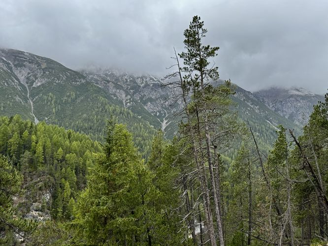
View of alpine mountains in Swiss National Park
46.657019, 10.174153
Safety information
For your own safety: plan ahead, let someone know where you'll be, and hike at your own risk.
Hazards
Rockfalls, Ledges, or Scrambles
Availability
All seasons
Surface type
Dirt
Trip Reports (Reviews)
Ready to help fellow hikers? Add a trip report to share your experience!
0
miles
/ 0 km
September 26, 2025
Hiking
No community routes found. To add your own hike as a Community Route for this Trail guide, leave a Trip Report with an attached GPX file.


You may also like

Explore
Best of the Alps: Hiking, Adventure & Scenery
Plan your ultimate European Alps adventure! Discover the best hiking trails, epic scenery, and villages in the Swiss Alps, Dolomites, Chamonix, and Lake Como.

Explore
Swiss Alps: Your Adventure Guide to Hikes & More
Explore the best Swiss Alps hikes and adventures! From the Bernese Oberland and Lauterbrunnen to Zermatt, Davos, and Walensee. Find trails, views, and more.

Explore
Zermatt Hikes: Best Matterhorn Views
Plan your Zermatt Matterhorn hiking trip! Discover unforgettable hikes, where to eat, and how to access the car-free village via Matterhorn Gotthard Bahn.

Explore
Dolomites Guide: Hikes, Lakes & Castles
Discover the Dolomites with our ultimate guide. Explore hikes like Seceda and Alpe di Siusi, turquoise alpine lakes like Lago di Braies, and castle ruins.

