Stone Quarry Falls via Pine Creek Trail at Tioga State Forest near Blackwell, Pennsylvania is an easy 2.4-mile out-and-back trail that leads to the scenic Stone Quarry Falls which sits just off-trail to the Pine Creek Trail within the Pennsylvania Grand Canyon.
Trails
This hike follows one named trail - the Pine Creek Trail.
Hike Description
The hike to Stone Quarry Falls begins in Blackwell, PA at the Robert McCullough Jr Pine Creek Access parking lot. Hikers will walk over to the Pine Creek Trail (where this GPS recording starts) to hike north. The trail passes through the village of Blackwell, which is a remote town at the southern end of the Pine Creek Gorge Natural Area.
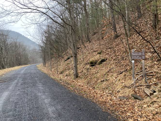
After passing through town, the trail will pass a yellow gate and then pass a junction with the Mid State Trail (MST) which leads to Johnson Cliff.
Off-Trail Climbing Rocks - Mile 0.55
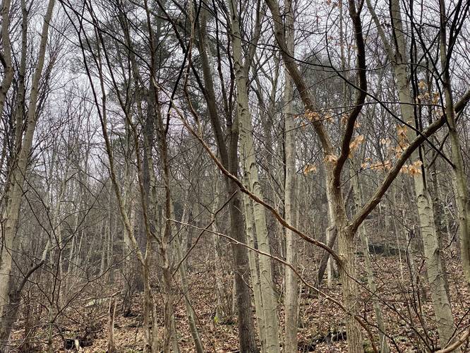
Not long after passing the trail junction with the MST, hikers may notice - when the leaves are off of the trees - some very large boulders sitting on the down-slopes of Fork Hill Mountain around mile 0.55. These massive rocks sit ~200-feet off-trail and up the mountain. There are a few white-painted blazes on 2 or 3 trees in this area - it's hard to say what these blazes are for, but this land is public. My assumption is these massive boulders are great for climbers since they sit in a remote and hard to get-to spot. The elevation grade leading up to these boulders looks painful and very steep - to even ascend and descend the 50-foot slope alongside the trail, it would be smart to use a rope and harness.
Climbing Cliff - Mile 1
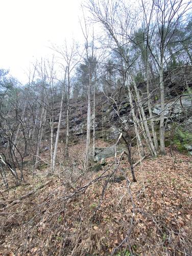
Just off of the trail, around mile 1, are more rock ledges. Some of these ledges head ~50-feet straight up the mountain. I labeled this area for rock climbing as some climbers may find these ledges interesting.
Pine Creek View - Mile 1.1
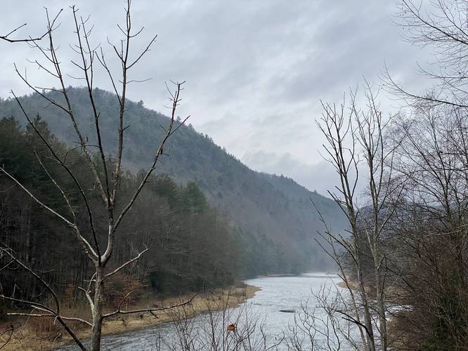
Around mile 1.1 - as of January 1, 2022 - is a cutout of trees along the creek with a view upstream which includes Pine Creek and the mountains adjacent. This is a nice place to take a break.
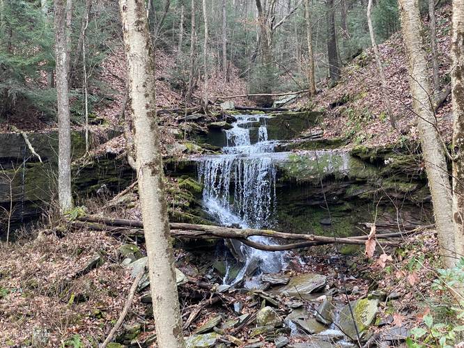
Stone Quarry Falls - Mile 1.25
Finally, after 1.2-miles of walking, hikers will reach Stone Quarry Run which is the creek that Stone Quarry Falls cascades down. Stone Quarry Falls a two-tiered waterfall where the lower falls is about 12-feet tall and about 5-feet tall in the "upper" falls section. During heavier rainfall seasons, there's a small cascade that spills over - what appears to be - quarried stone to the left-hand side of the main waterfall. Stone Quarry Falls is located ~50-feet from the trail so hikers, bikers, and even horseback riders can enjoy this waterfall without any effort. This GPS track heads up the creek to investigate more falling water, but I stopped about 100-feet beyond the top of Stone Quarry Falls as I didn't find much of anything. Also note the name - there used to be a stone quarry in and around this hollow of Fork Hill Mountain. Some quarry activity can still be seen in the rocks that surround the waterfall - just look for flat rocks that appear to look cut.
The hike back is simple - just hike out and enjoy the scenery of Pine Creek and the surrounding mountains.
Biking
Biking is allowed on this trail however, as of January 1, 2022 no e-bikes are allowed on this trail along with any other motorized vehicles.
Pets
Dogs are allowed if leashed and their waste should be carried out by the hiker.
Views
There are some views along the Pine Creek Trail of Pine Creek.
Trails
This hike follows one named trail - the Pine Creek Trail.
Hike Description
The hike to Stone Quarry Falls begins in Blackwell, PA at the Robert McCullough Jr Pine Creek Access parking lot. Hikers will walk over to the Pine Creek Trail (where this GPS recording starts) to hike north. The trail passes through the village of Blackwell, which is a remote town at the southern end of the Pine Creek Gorge Natural Area.
After passing through town, the trail will pass a yellow gate and then pass a junction with the Mid State Trail (MST) which leads to Johnson Cliff.
Off-Trail Climbing Rocks - Mile 0.55
Not long after passing the trail junction with the MST, hikers may notice - when the leaves are off of the trees - some very large boulders sitting on the down-slopes of Fork Hill Mountain around mile 0.55. These massive rocks sit ~200-feet off-trail and up the mountain. There are a few white-painted blazes on 2 or 3 trees in this area - it's hard to say what these blazes are for, but this land is public. My assumption is these massive boulders are great for climbers since they sit in a remote and hard to get-to spot. The elevation grade leading up to these boulders looks painful and very steep - to even ascend and descend the 50-foot slope alongside the trail, it would be smart to use a rope and harness.
Climbing Cliff - Mile 1
Just off of the trail, around mile 1, are more rock ledges. Some of these ledges head ~50-feet straight up the mountain. I labeled this area for rock climbing as some climbers may find these ledges interesting.
Pine Creek View - Mile 1.1
Around mile 1.1 - as of January 1, 2022 - is a cutout of trees along the creek with a view upstream which includes Pine Creek and the mountains adjacent. This is a nice place to take a break.
Stone Quarry Falls - Mile 1.25
Finally, after 1.2-miles of walking, hikers will reach Stone Quarry Run which is the creek that Stone Quarry Falls cascades down. Stone Quarry Falls a two-tiered waterfall where the lower falls is about 12-feet tall and about 5-feet tall in the "upper" falls section. During heavier rainfall seasons, there's a small cascade that spills over - what appears to be - quarried stone to the left-hand side of the main waterfall. Stone Quarry Falls is located ~50-feet from the trail so hikers, bikers, and even horseback riders can enjoy this waterfall without any effort. This GPS track heads up the creek to investigate more falling water, but I stopped about 100-feet beyond the top of Stone Quarry Falls as I didn't find much of anything. Also note the name - there used to be a stone quarry in and around this hollow of Fork Hill Mountain. Some quarry activity can still be seen in the rocks that surround the waterfall - just look for flat rocks that appear to look cut.
The hike back is simple - just hike out and enjoy the scenery of Pine Creek and the surrounding mountains.
Biking
Biking is allowed on this trail however, as of January 1, 2022 no e-bikes are allowed on this trail along with any other motorized vehicles.
Pets
Dogs are allowed if leashed and their waste should be carried out by the hiker.
Views
There are some views along the Pine Creek Trail of Pine Creek.