Located on the east side of the Susquehanna River on the edge of Lancaster County sits the scenic Star Rock Overlook in Chestnut Grove Natural Area near Conestoga, Pennsylvania and features beautiful cliff side views of the river.
This short and easy 1.6-mile out-and-back hike leads visitors to the cliff's edge where you'll find panoramic views of the Susquehanna River with minimal effort.
Starting out, you'll hike down the dirt service road-like path that acts as a main vein into the park. Just as you reach your first trail junction, as of January 2026, there will be signage for Star Rock Overlook - simply follow the signs and continue hiking straight.
Snakes: Pennsylvania is home to the Timber Rattlesnake and Copperhead which can be found roaming the forest and basking in exposed rocky areas between April and October each year. While very rare in this area, be on the lookout and give any you find plenty of space.
This short and easy 1.6-mile out-and-back hike leads visitors to the cliff's edge where you'll find panoramic views of the Susquehanna River with minimal effort.
Hike to Star Rock Overlook
This hike begins at the main parking lot at Chestnut Grove Natural Area where visitors and hikers will find several trails that lead through the park. The main focus of this hike are the views of the river, so this route brings you to Star Rock Overlook on the most direct path.Starting out, you'll hike down the dirt service road-like path that acts as a main vein into the park. Just as you reach your first trail junction, as of January 2026, there will be signage for Star Rock Overlook - simply follow the signs and continue hiking straight.
Left-Turn to Star Rock - Mile 0.25
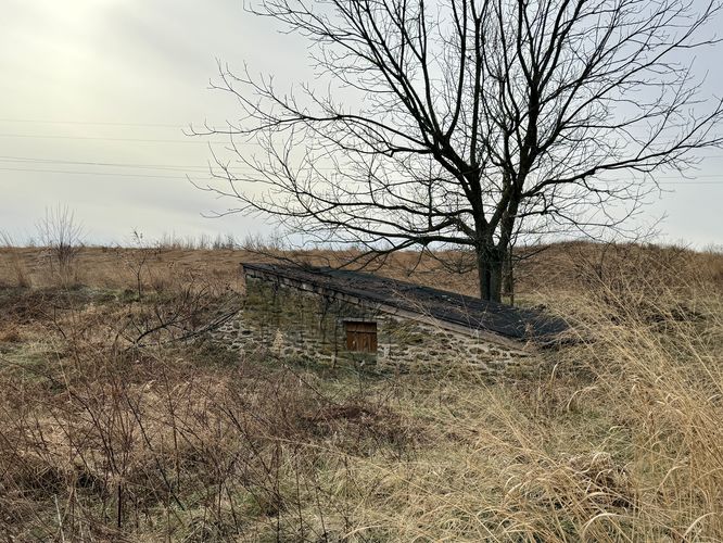
Just beyond the first trail junction, the main path will cross a creek before reaching a farmland storage shed located on your left-hand side. Just behind it is the 2nd trail junction with more signage for Star Rock Overlook. Take a left-hand turn here to continue hiking toward the overlook. The trail will lead downhill as it runs along the top of a small bluff with a "valley" below your feet. Not long after, the trail leads uphill and passes through skinny, open fields and eventually reaches a bench where the fields meet the forest once again.Reaching Star Rock Overlook - Mile 0.75
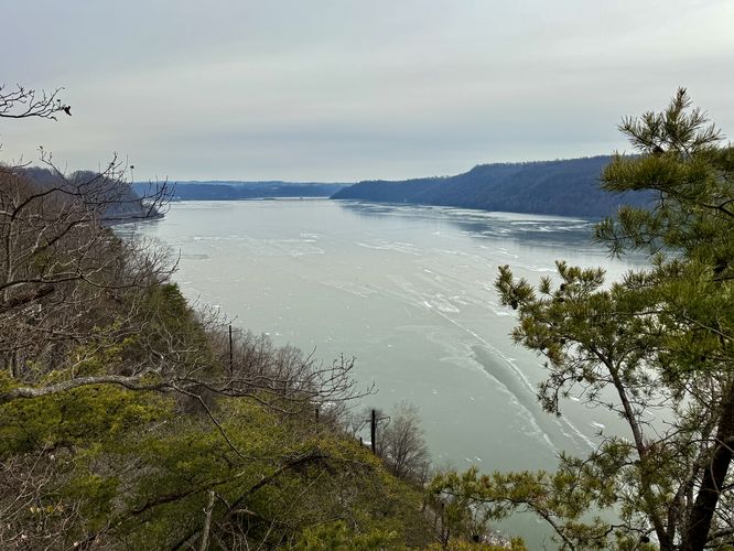
At the far corner of the natural area, just behind the bench, near mile 0.75 is an offshoot path that leads through the forest and downhill. At the very end of this unmarked trail is the Star Rock Overlook. From Star Rock Overlook, hikers and visitors will find beautiful views of the Susquehanna River below your feet as it flows south toward Maryland. Star Rock Overlook is primarily covered in red pine trees which dot the bedrock and provide some foreground color for photos. Views from Star Rock Overlook are primarily to the south and northwest with bluffs and hills that swoop up from the banks of the Susquehanna River. Watch your step though! Star Rock Overlook has no fences or railings and a fall from these cliffs would likely be fatal.Hiking Back from Star Rock - Mile 0.75 to 1.6
After exploring the Susquehanna River views from Star Rock Overlook, this hike leads right back to parking. Follow the same trails you hiked in on and return to the parking lot to wrap up this short and easy 1.6-mile out-and-back hike.Parking & How to Get to Star Rock Overlook
Visitors and hikers to Star Rock Overlook will find a small parking lot along the west side of Chestnut Grove Road near Conestoga, PA at the coordinates provided: 39.948354, -76.432257. The lot is large enough to fit less than a dozen vehicles as of January 2026.Pets
Dogs are allowed only if leashed and cleaned up after.Explore More River Views!
The Susquehanna River offers endless opportunities for hikers and nature lovers to discover breathtaking vistas. Whether you are chasing the golden hour or looking for a rugged trek, the river hills of Central Pennsylvania never disappoint. Before you leave the area, consider exploring these short, family-friendly and stunning river views in York and Lancaster Counties: Schull's Rock Overlook, Highpoint Scenic Vista, Chickies Rock Overlook, Breezyview Overlook, House Rock Overlook, and Hawk Point & Wissler Run Overlooks.Warning
Steep cliffs: Star Rock Overlook sits high above the Susquehanna River with steep cliffs and sheer drop-offs. Watch your step and stay away from the cliff's edge for your own safety.Snakes: Pennsylvania is home to the Timber Rattlesnake and Copperhead which can be found roaming the forest and basking in exposed rocky areas between April and October each year. While very rare in this area, be on the lookout and give any you find plenty of space.