Located on the east side of the Susquehanna River in Lancaster County near Columbia, PA sits the popular Chickies Rock Overlook at Chickies Rock County Park, that features beautiful views of the river.
This short, family-friendly hike leads visitors 1 mile out-and-back to the Chickies Rock Overlook where you'll find panoramic views of the Susquehanna River from high above the cliff's edge.
This route follows the flat and easy Chickies Rock Overlook Trail to reach the views. Along the way, you'll pass steep rocky bluffs and seasonal, obstructed views of the Susquehanna River as the trail cuts through the forest to reach the edge of the cliffs.
Snakes: Pennsylvania is home to the Timber Rattlesnake and Copperhead which can be found roaming the forest and basking in exposed rocky areas between April and October each year. While very rare in this area, be on the lookout and give any you find plenty of space.
This short, family-friendly hike leads visitors 1 mile out-and-back to the Chickies Rock Overlook where you'll find panoramic views of the Susquehanna River from high above the cliff's edge.
Exploring Chickies Rock Overlook
Visitors to Chickies Rock Overlook will find a dirt trail located on the west side of Chickies Hill Road at Chickies Rock County Park. The trail leads into the forest, first by heading up a short but moderate grade. At the top of the moderate grade, hikers have two options - either follow the flat Chickies Rock Overlook Trail out to the vista or hike up the nearby bluff which leads to the same place.This route follows the flat and easy Chickies Rock Overlook Trail to reach the views. Along the way, you'll pass steep rocky bluffs and seasonal, obstructed views of the Susquehanna River as the trail cuts through the forest to reach the edge of the cliffs.
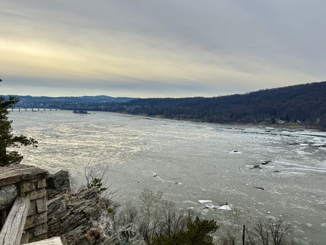
Chickies Rock Overlook - Mile 0.5
Just before you reach the edge of the cliffs along Chickies Rock, the trail leads in two directions to reach two different viewing platforms. These overlook viewpoints provide visitors with the same north/south-facing views of the Susquehanna River, so choose which one (or both) you wish to visit. The two overlook platforms allow visitors to spread out a bit so you can enjoy views with a bit more solitude. This route leads to the northern-most overlook which arguably is a bit harder to traverse. The trail leads down a path of jagged bedrock to reach a fence that sits along the cliffs of Chickies Rock. Here, you'll find beautiful panoramic views of the Susquehanna River to the north and glimpses of views to the south as the river flows around a large bend on its way toward Maryland.Hiking Back - Mile 0.5 to 1
When you're done exploring the river views at Chickies Rock, the hike back to parking follows the same route you hiked in on or you can opt to take the side trail that leads up the bluff and back toward the first trail junction. Wrap up the 1 mile out-and-back hike back at the parking lot.Parking & How to Get to Chickies Rock Overlook
Visitors and hikers will find a very large dirt parking lot on the west side of Chickies Hill Road near Columbia, Pennsylvania at the coordinates provided: 40.051601, -76.51705. The parking lot is large enough to fit several dozen vehicles as of January 2026.Pets
Dogs are allowed only if leashed and must be cleaned up after.Explore More River Views!
The Susquehanna River offers endless opportunities for hikers and nature lovers to discover breathtaking vistas. Whether you are chasing the golden hour or looking for a rugged trek, the river hills of Central Pennsylvania never disappoint. Before you leave the area, consider exploring these short, family-friendly and stunning river views in York and Lancaster Counties: Schull's Rock Overlook, Highpoint Scenic Vista, Breezyview Overlook, Star Rock Overlook, House Rock Overlook, and Hawk Point & Wissler Run Overlooks.Warning
Steep cliffs: This hike leads out to steep cliffs that sit high above the river with sheer drop-offs. Stay back from the cliff's edge and obey the signage to not throw rocks (people can be below!). Stay on the right side of the fence for your own safety.Snakes: Pennsylvania is home to the Timber Rattlesnake and Copperhead which can be found roaming the forest and basking in exposed rocky areas between April and October each year. While very rare in this area, be on the lookout and give any you find plenty of space.