Loading...

๐ŸŒฒ WINTER SALE! 50% OFF on Supporter Accounts โ€” now through December 31st. Unlock a full year of exclusive website & app perks for better hikes. Learn More.

Schwarzsee Lake Trail

Directions
Map
Pictures
Download Schwarzsee Lake Trail GPX Data to the MyHikes Mobile App
Distance:
1.1 km / 0.7 Miles
Type:
Loop
Difficulty:
Easy
Time to Hike:
~20 minutes
Features:
Surface Type:
Dirt
Town:
Davos, Switzerland
Get Directions:
46.845902, 9.87273
Added:
September 26, 2025
Updated:
November 24, 2025
Copy Trail Link Hiking this trail? Send a friend or family member a link to this trail guide for your own safety. Hike at your own risk (disclaimer)
Loading...
Loading...
18m

Total Change
21m

Ascent
21m

Descent

Download the GPX Data for Offline Use

Supporters get exclusive access to download trail routes to the MyHikes app for offline use. Stay prepared on your adventure, even without an internet connection! Become a Supporter today to unlock this feature and hike with confidence.

Download Schwarzsee Lake Trail GPX Data to the MyHikes Mobile App

Key Takeaways

  • The Schwarzsee Trail is a 1.1 km (0.7-mile) loop near Davos Laret offering easy, flat hiking along the lake's edge (a perfect Schwarzsee Rundweg). Ideal for a quick walk, families, or a beginner-friendly introduction to Swiss hiking.
  • Experience solitude and stunning panoramic reflections of the Pischahorn and Alpeltispitz on the glassy, dark-green waters of the Black Lake. Alpine views are guaranteed around the entire trail loop.
  • Easily accessible from the public Lareterstrasse parking lot (Davos Laret). The trail includes a picnic area, public restrooms, and fun summer amenities like a rope swing and swimming dock on the east shore.

Schwarzsee Lake Trail

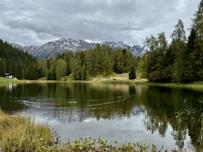
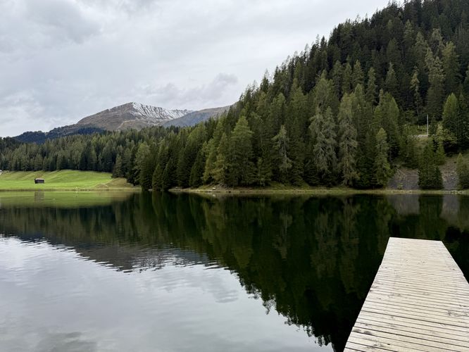
Discover the Schwarzsee Lake Trail, a short and serene 1.1 km (0.7-mile) loop hike offering unparalleled solitude and stunning Swiss Alps views just minutes from Davos, Switzerland. Perfect for all skill levels, this easily accessible trail guides you along the glassy, dark-green waters of the Black Lake (Schwarzsee). Begin your adventure at the Lareterstrasse public parking lot, then descend to the lake's flat, scenic edge.

Trail Guide: Schawrzsee Lake Trail Loop Hike

This short loop hike begins at a public parking lot located on the south side of Lareterstrasse in Davos Laret. The walk starts here where visitors will head down the road to reach a short, but steep trail that leads down to the edge of Schwarzsee (Black Lake). Along the way, you'll find restrooms, a picnic area, and views of the lake from the hillside.

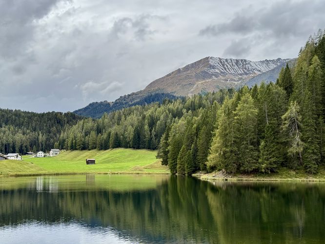
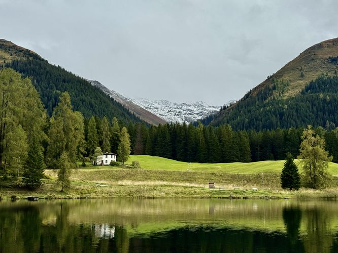
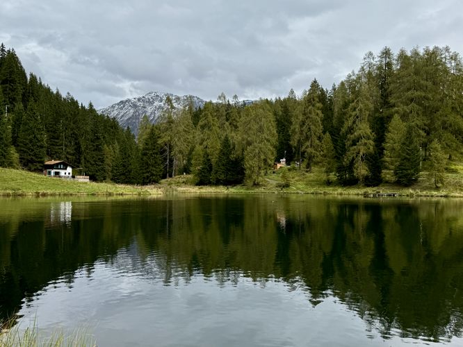
Once you reach the edge of Schwarzsee, the loop trail leads in both west and south directions. This trail guide leads you west along the northern shore of the Black Lake. From the north shore of Schwarzsee, you'll find a quaint Swiss chalet that sits just off-trail with a view of the lake below. Towering Swiss Alps peaks sit overhead and can be found throughout the hike around the lake. Some of the best views come into view on the western side of Schwarzsee with views of the snow-capped Pischahorn.

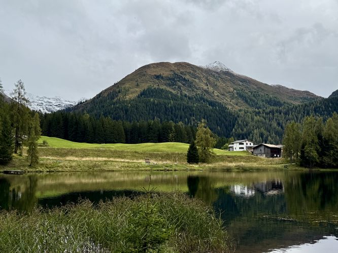
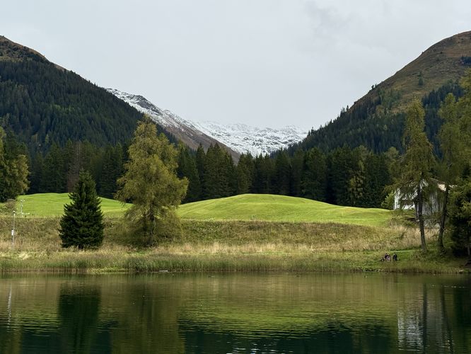
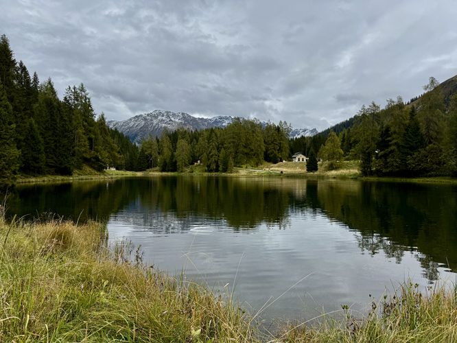
As the Schwarzsee Lake Trail loops around the south side of the water's edge, hikers will find more beautiful views of the Black Lake's glassy waters with more towering Swiss Alps in the background. Here, along the south shore, you'll find views of the snow-capped Alpeltispitz.

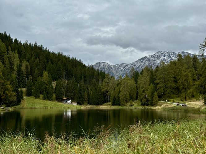
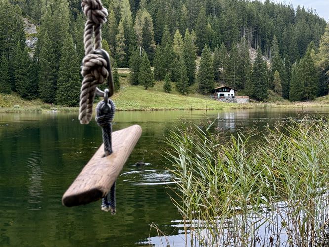
The Schwarzsee Lake Trail then leads visitors across a small footbridge that spans crystal-clear water that flows out through a small tributary stream before running up the eastern side of the lake. Along the east side of the Black Lake, the views become a little less spectacular, but instead you'll find a fun rope swing (great for families during warm months) and a dock that juts out into the water. More Alps views can be found near the lake's dock with views of the alpine slopes of Salezerhora that towers over the center of Davos.

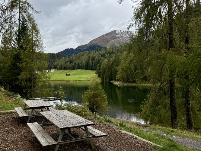
Following the trail back uphill, passing the picnic area, hikers will head up Lareterstrasse and then take a right-hand turn to reach the parking lot. The hike ends back at the parking lot for a 1.1 km (0.7 mile) hike.

Parking & Directions: Getting to Schwarzsee in Davos

Visitors to Schwarzsee (the Black Lake) will find a somewhat confusing parking lot for the hike. You'll first drive through the center of Davos Laret along the road, Lareterstrasse, before you pass the lake on the left-hand side. As the road, Lareterstrasse, climbs uphill, there will be a right-hand turn that leads to a public parking lot. The parking lot is located next to an old building that appears to be abandoned, as of September 2025. Here, you can pay to park your vehicle based on an hourly rate.

Pets

Dogs are allowed only if leashed and must be cleaned up after.
Explore 9 trails near Davos, Switzerland
  1. Parking

    46.845902, 9.87273
  2. Main Trailhead

    46.845902, 9.87273
  3. View of Schwarzsee from the northeast corner of the lake

    46.846206, 9.87125
    View of Schwarzsee from the northeast corner of the lake
  4. Alpine views from the northern shore of Schwarzsee

    46.846364, 9.869822
    Alpine views from the northern shore of Schwarzsee
  5. East-facing view of Alps above Schwarzsee in Davos

    46.846242, 9.869422
    East-facing view of Alps above Schwarzsee in Davos
  6. Snow-capped alpine mountains in the distance at Schwarzsee in Davos

    46.845478, 9.869483
    Snow-capped alpine mountains in the distance at Schwarzsee in Davos
  7. View of Schwarzsee and Alps from the west side of the lake

    46.845478, 9.869486
    View of Schwarzsee and Alps from the west side of the lake
  8. View of Schwarzsee and towering Alps from the south shore of the lake

    46.844644, 9.86855
    View of Schwarzsee and towering Alps from the south shore of the lake
  9. A duck swims through the glassy waters of Schwarzsee

    46.844392, 9.868644
    A duck swims through the glassy waters of Schwarzsee
  10. View from the southern end of Schwarzsee with Swiss Alps

    46.844264, 9.869042
    View from the southern end of Schwarzsee with Swiss Alps
  11. Rope swing at Schwarzsee

    46.844844, 9.870122
    Rope swing at Schwarzsee
  12. Schwarzsee dock

    46.845833, 9.871019
    Schwarzsee dock
  13. Schwarzsee picnic area

    46.846286, 9.871478
    Schwarzsee picnic area
No community routes found. To add your own hike as a Community Route for this Trail guide, leave a Trip Report with an attached GPX file.

Seasons

All

Photo Albums

+ Add Photo Album

Upload your photos from the trail to help others know what to expect.

Preview of the MyHikes mobile app interface

Track, Log, and Explore Hikes with the MyHikes App

Shop Landscape Prints
Shop our Alps landscape prints to support MyHikes!

Trip Reports (Reviews)

Ready to help fellow hikers? Add a trip report to share your experience and provide valuable insights for those planning their next hike. Your review makes the trail better for everyone.

Rated 5.0 out of 5 based on 1 rating.
0.7 miles / 1.1 km
September 26, 2025
This lake is very secluded, we only saw one other family at the lake that day. Great views of the Swiss Alps and a short walk around the lake. This is a must-see lake if you're driving through Davos and want to explore a short hike with very few people.
Hiking

Explore Hiking Trails

You May Also Like

Colorado's Million Dollar Highway - Plan a day's drive adventure along the iconic Million Dollar Highway in Colorado. Explore the best short trails, roadside stops, waterfalls, vistas, ghost towns, and hot springs within a ~6 hour road trip.
Explore

Colorado's Million Dollar Highway

Plan a day's drive adventure along the iconic Million Dollar Highway in Colorado. Explore the best short trails, roadside stops, waterfalls, vistas, ghost towns, and hot springs within a ~6 hour road trip.

Read
Glacier's Going-to-the-Sun Road - Discover the breathtaking beauty of Glacier National Park along the iconic Going-to-the-Sun Road. From stunning roadside stops to picturesque waterfalls and vistas, this engineering marvel offers endless opportunities for exploration.
Explore

Glacier's Going-to-the-Sun Road

Discover the breathtaking beauty of Glacier National Park along the iconic Going-to-the-Sun Road. From stunning roadside stops to picturesque waterfalls and vistas, this engineering marvel offers endless opportunities for exploration.

Read
New York's Best Waterfalls - Whether you're planning a day hike, roadside stop, or a leisurely short walk, this guide provides hikers, travelers, and locals alike with 63 different locations to over 100 scenic waterfalls to help plan your next adventure!
Explore

New York's Best Waterfalls

Whether you're planning a day hike, roadside stop, or a leisurely short walk, this guide provides hikers, travelers, and locals alike with 63 different locations to over 100 scenic waterfalls to help plan your next adventure!

Read

Before you boogie...

Find our trail guides useful? Consider becoming a Supporter to unlock perks!

MyHikes is an indie platform that makes exploring public trails easier for everyone. The platform has no investors, no ads, and is owned and operated by one person, Dave Miller. Dave has personally mapped and written over 1,800 trail guides on MyHikes for the public to explore. MyHikes has helped millions outdoor enthusiasts plan their next adventure.

But it takes a lot of time ๐Ÿ•ฆ, money ๐Ÿ’ฐ, work, and espresso shots โ˜• to run MyHikes, including hiking , mapping , writing , and publishing new trails with high-quality (accurate) information... along with software engineering (coding) the platform like building new features, website and mobile app development (iOS and Android), site maintainance . and much much more.

Supporters unlock website and mobile app perks with an annual one-time payment of $25 (you renew) ๐Ÿ˜Ž๐Ÿ‘. Or you can simply make a Donation of your choice. Otherwise, you can support us by telling your friends about MyHikes - both quick and free ๐ŸŽ‰

Admin avatar

Dave Miller
MyHikes Founder
๐Ÿช We use cookies to learn about site usage, performance, and to serve map tiles. You may block cookies manually in the browser. By continuing to use MyHikes, you agree. Learn more