Loading...

๐ŸŽ Holiday Gifts Alert! Get 30% off the artist's markup on all landscape prints with code HXJBJU to support MyHikes! Browse prints.

San Gottardo Panoramic Viewpoint

Directions
Map
Pictures
Send to App
Distance:
0 km / 0 Miles
Type:
Out-and-Back
Difficulty:
Easy
Time to Hike:
~5 minutes
Features:
Surface Type:
Universal Access
Town:
Airolo, Switzerland
Get Directions:
46.533742, 8.579949
Added:
September 20, 2025
Updated:
November 11, 2025
Copy Trail Link Hiking this trail? Send a friend or family member a link to this trail guide for your own safety. Hike at your own risk (disclaimer)
Loading...

Download the Trail Route for Offline Use

Supporters get exclusive access to download trail routes to the MyHikes app for offline use. Stay prepared on your adventure, even without an internet connection! Become a Supporter today to unlock this feature and hike with confidence.

Send to App

Key Takeaways

  • Enjoy effortless, universally accessible 180-degree views right from your car on the Gotthard Passโ€”a perfect roadside stop in Ticino.
  • Witness the incredible 650-meter Riale di Sorescia waterfall and the historic serpentine Tremola road from a single, stunning location.
  • This viewpoint is a must-see for any Switzerland road trip itinerary, offering high-alpine beauty at 1,650 meters (5,412 feet) without the need for hiking.

San Gottardo Panoramic Viewpoint

Looking for an unforgettable Swiss Alps view near Airolo, Switzerland? The San Gottardo Panoramic Viewpoint offers just that. Perched high above the charming village of Airolo in the canton of Ticino, this accessible roadside stop rewards visitors with sweeping, majestic views of the surrounding mountains and the historic Gotthard Pass region.

Effortless Alpine Beauty on Gotthard Pass

The San Gottardo Panoramic Viewpoint is an easily accessible roadside stop located directly on the historic Gotthard Pass road (Passo del San Gottardo) in the canton of Ticino.

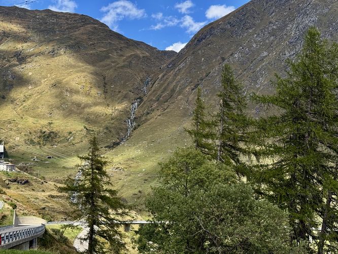
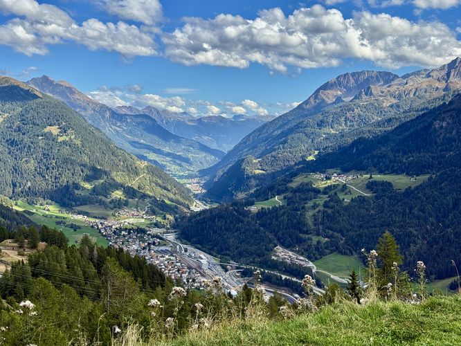
This viewpoint is designed for universal access and convenience. Visitors can literally step out of their car โ€” or even stay inside on a chilly day โ€” to enjoy the magnificent, sweeping vistas of the surrounding Alpine peaks and the Leventina Valley. From the San Gottardo Panoramic Viewpoint, visitors enjoy truly majestic 180-degree Swiss Alps views of the Gotthard Pass region. Below your feet the serpentine Tremola road winds down the mountain towards Airolo. Equally impressive is the cascading Riale di Sorescia waterfall, which tumbles an astounding 650 meters (2,132 feet) down the mountainside. This is the perfect spot for easy, accessible sightseeing and photography on your Switzerland road trip.

Parking & Directions: How to Get to San Gottardo Panoramic Viewpoint

Visitors will find a small parking turnout located at the coordinates provided, located on the east side of Passo del San Gottardo. From Airolo, follow signs toward the Gotthard Pass (Passo del San Gottardo). Parking is available near the top of the pass at the coordinates provided (seasonal restrictions apply).

Seasonal Closures

The Gotthard Pass road is a classic seasonal route. Always check the current status before setting out, especially early or late in the season, as winter closures due to snow are mandatory and often last from November to May.

Pets

Dogs are allowed if leashed and must be cleaned up after.
Explore 7 trails near Airolo, Switzerland
  1. Parking

    46.533742, 8.579949
  2. Main Trailhead

    46.533742, 8.579949
  3. View of the 650m tall Riale di Sorescia waterfall

    46.533733, 8.579994
    View of the 650m tall Riale di Sorescia waterfall
  4. Stunning Alps view from Gottard Pass high above Airolo

    46.533611, 8.580094
    Stunning Alps view from Gottard Pass high above Airolo
No community routes found. To add your own hike as a Community Route for this Trail guide, leave a Trip Report with an attached GPX file.

Seasons

Spring, Summer, Fall

Photo Albums

+ Add Photo Album

Upload your photos from the trail to help others know what to expect.

Trip Reports (Reviews)

Ready to help fellow hikers? Add a trip report to share your experience and provide valuable insights for those planning their next hike. Your review makes the trail better for everyone.

Rated 4.0 out of 5 based on 1 rating.
0 miles / 0 km
September 20, 2025
Great views from Gotthard Pass of Airolo, the Alps of Ticino, and the massive waterfall tumbling down from the pass. No hiking required, great for road trips.
Hiking

Explore Hiking Trails

You May Also Like

Colorado's Million Dollar Highway - Plan a day's drive adventure along the iconic Million Dollar Highway in Colorado. Explore the best short trails, roadside stops, waterfalls, vistas, ghost towns, and hot springs within a ~6 hour road trip.
Explore

Colorado's Million Dollar Highway

Plan a day's drive adventure along the iconic Million Dollar Highway in Colorado. Explore the best short trails, roadside stops, waterfalls, vistas, ghost towns, and hot springs within a ~6 hour road trip.

Read
Glacier's Going-to-the-Sun Road - Discover the breathtaking beauty of Glacier National Park along the iconic Going-to-the-Sun Road. From stunning roadside stops to picturesque waterfalls and vistas, this engineering marvel offers endless opportunities for exploration.
Explore

Glacier's Going-to-the-Sun Road

Discover the breathtaking beauty of Glacier National Park along the iconic Going-to-the-Sun Road. From stunning roadside stops to picturesque waterfalls and vistas, this engineering marvel offers endless opportunities for exploration.

Read
New York's Best Waterfalls - Whether you're planning a day hike, roadside stop, or a leisurely short walk, this guide provides hikers, travelers, and locals alike with 63 different locations to over 100 scenic waterfalls to help plan your next adventure!
Explore

New York's Best Waterfalls

Whether you're planning a day hike, roadside stop, or a leisurely short walk, this guide provides hikers, travelers, and locals alike with 63 different locations to over 100 scenic waterfalls to help plan your next adventure!

Read

Before you boogie...

Find our trail guides useful? Consider becoming a Supporter to unlock perks!

MyHikes is an indie platform that makes exploring public trails easier for everyone. The platform has no investors, no ads, and is owned and operated by one person, Dave Miller. Dave has personally mapped and written over 1,800 trail guides on MyHikes for the public to explore. MyHikes has helped millions outdoor enthusiasts plan their next adventure.

But it takes a lot of time ๐Ÿ•ฆ, money ๐Ÿ’ฐ, work, and espresso shots โ˜• to run MyHikes, including hiking , mapping , writing , and publishing new trails with high-quality (accurate) information... along with software engineering (coding) the platform like building new features, website and mobile app development (iOS and Android), site maintainance . and much much more.

Supporters unlock website and mobile app perks with an annual one-time payment of $25 (you renew) ๐Ÿ˜Ž๐Ÿ‘. Or you can simply make a Donation of your choice. Otherwise, you can support us by telling your friends about MyHikes - both quick and free ๐ŸŽ‰

Admin avatar

Dave Miller
MyHikes Founder
๐Ÿช We use cookies to learn about site usage, performance, and to serve map tiles. You may block cookies manually in the browser. By continuing to use MyHikes, you agree. Learn more