Loading...

🎁 Holiday Gifts Alert! Get 30% off the artist's markup on all landscape prints with code HXJBJU to support MyHikes! Browse prints.

Rhône Valley Overlook

Directions
Map
Pictures
Send to App
Distance:
0 km / 0 Miles
Type:
Out-and-Back
Difficulty:
Easy
Time to Hike:
~5 minutes
Features:
Surface Type:
Dirt
Town:
Martigny-Combe, Switzerland
Get Directions:
46.075821, 7.02064
Added:
September 20, 2025
Updated:
November 09, 2025
Copy Trail Link Hiking this trail? Send a friend or family member a link to this trail guide for your own safety. Hike at your own risk (disclaimer)
Loading...

Download the Trail Route for Offline Use

Supporters get exclusive access to download trail routes to the MyHikes app for offline use. Stay prepared on your adventure, even without an internet connection! Become a Supporter today to unlock this feature and hike with confidence.

Send to App

Key Takeaways

  • Stunning roadside stop offering panoramic vistas of the vineyard-filled Rhône Valley and the Swiss Alps near the French border.
  • Convenient, no-hike viewpoint located directly on the Route de la Forclaz mountain pass, ideal for road trippers traveling between Switzerland and France.
  • Perfect, accessible parking turnout in Martigny-Combe, Switzerland, for photographers and motorists seeking breathtaking views.

Rhône Valley Overlook

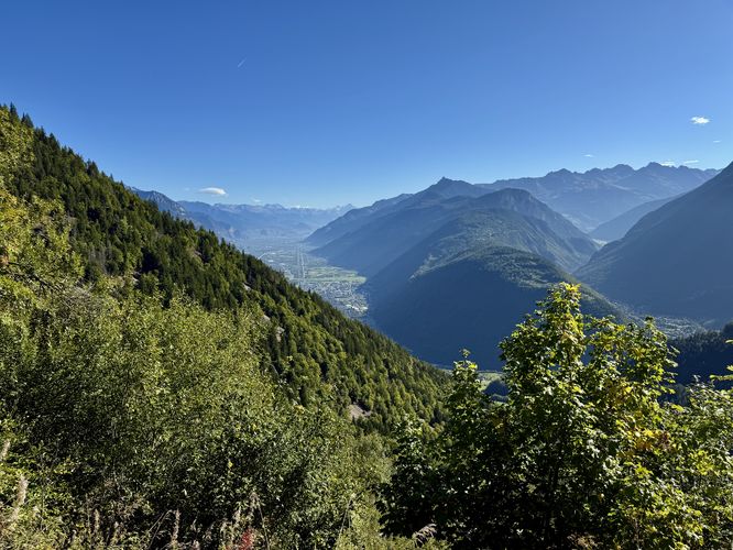
Take a breathtaking pause high above the vineyard-filled Rhône Valley at this must-see roadside viewpoint. Located in Martigny-Combe, Switzerland, right near the French border, the Rhône Valley Overlook offers panoramic views that showcase the massive scale of the valley and the majestic Swiss Alps.

Exploring the Rhône Valley Overlook

This popular spot is a road tripper's favorite for a reason! Despite being an easy roadside stop—no hiking required—the views are simply unforgettable. As you travel along the scenic Route de la Forclaz (Rte de la Forclaz), this high-elevation viewpoint offers a spectacular perspective.

After navigating the winding mountain pass road, you'll be rewarded with a sweeping vista. Look down upon the valley floor and appreciate the terraced vineyards that define the landscape below. It's the perfect stop to stretch your legs and snap some stunning photos before crossing into France or continuing your journey through Switzerland.

Parking

Visitors will find a large parking turnout at the coordinates provided, located on a hairpin turn along Rte de la Forclaz.

Pets

Dogs are allowed only if leashed and must be cleaned up after.
Explore 5 trails near Martigny-Combe, Switzerland
  1. Parking

    46.075821, 7.02064
  2. Main Trailhead

    46.075884, 7.020753
  3. View of the Rhone Valley

    46.075883, 7.020803
    View of the Rhone Valley
No community routes found. To add your own hike as a Community Route for this Trail guide, leave a Trip Report with an attached GPX file.

Seasons

All

Photo Albums

+ Add Photo Album

Upload your photos from the trail to help others know what to expect.

Trip Reports (Reviews)

Ready to help fellow hikers? Add a trip report to share your experience and provide valuable insights for those planning their next hike. Your review makes the trail better for everyone.

Rated 5.0 out of 5 based on 1 rating.
0 miles / 0 km
September 20, 2025
Drove into France from this road then on our way back we stopped at this overlook. Beautiful perspective of the entire valley.
Hiking

Explore Hiking Trails

You May Also Like

Colorado's Million Dollar Highway - Plan a day's drive adventure along the iconic Million Dollar Highway in Colorado. Explore the best short trails, roadside stops, waterfalls, vistas, ghost towns, and hot springs within a ~6 hour road trip.
Explore

Colorado's Million Dollar Highway

Plan a day's drive adventure along the iconic Million Dollar Highway in Colorado. Explore the best short trails, roadside stops, waterfalls, vistas, ghost towns, and hot springs within a ~6 hour road trip.

Read
Glacier's Going-to-the-Sun Road - Discover the breathtaking beauty of Glacier National Park along the iconic Going-to-the-Sun Road. From stunning roadside stops to picturesque waterfalls and vistas, this engineering marvel offers endless opportunities for exploration.
Explore

Glacier's Going-to-the-Sun Road

Discover the breathtaking beauty of Glacier National Park along the iconic Going-to-the-Sun Road. From stunning roadside stops to picturesque waterfalls and vistas, this engineering marvel offers endless opportunities for exploration.

Read
New York's Best Waterfalls - Whether you're planning a day hike, roadside stop, or a leisurely short walk, this guide provides hikers, travelers, and locals alike with 63 different locations to over 100 scenic waterfalls to help plan your next adventure!
Explore

New York's Best Waterfalls

Whether you're planning a day hike, roadside stop, or a leisurely short walk, this guide provides hikers, travelers, and locals alike with 63 different locations to over 100 scenic waterfalls to help plan your next adventure!

Read

Before you boogie...

Find our trail guides useful? Consider becoming a Supporter to unlock perks!

MyHikes is an indie platform that makes exploring public trails easier for everyone. The platform has no investors, no ads, and is owned and operated by one person, Dave Miller. Dave has personally mapped and written over 1,800 trail guides on MyHikes for the public to explore. MyHikes has helped millions outdoor enthusiasts plan their next adventure.

But it takes a lot of time 🕦, money 💰, work, and espresso shots ☕ to run MyHikes, including hiking , mapping , writing , and publishing new trails with high-quality (accurate) information... along with software engineering (coding) the platform like building new features, website and mobile app development (iOS and Android), site maintainance . and much much more.

Supporters unlock website and mobile app perks with an annual one-time payment of $25 (you renew) 😎👍. Or you can simply make a Donation of your choice. Otherwise, you can support us by telling your friends about MyHikes - both quick and free 🎉

Admin avatar

Dave Miller
MyHikes Founder
🍪 We use cookies to learn about site usage, performance, and to serve map tiles. You may block cookies manually in the browser. By continuing to use MyHikes, you agree. Learn more