The Rattlesnake Creek Falls and Babb Creek Falls hike at Tioga State Forest near Wellsboro, Pennsylvania is a moderate 4.2-mile out-and-back hike that features four waterfalls including the 10-foot tall Rattlesnake Falls.
Important Private Land Note: The tiny parking turnout and the land off of the service road (for the first 0.3-miles of the hike) is technically private land. Please respect all land owners and do not park near the trailhead if there are other cars around. Park at your own risk and do not leave your vehicle for too long. With regard to backpacking, do not use this hiking guide to reach these waterfalls since long-term parking is not recommended. Please consider using the Sand Run Falls Trail guide instead; however, hikers will need to stay on the Mid State Trail beyond Sand Run Falls heading west to reach these waterfalls.
Trails
This hike follows several trails: Reese Road (service road), Mid State Trail.
Hike Description
Hikers will begin by hiking down the service road, labeled Reese Road on the Tioga State Forest trail map. After passing the yellow gate, the trail levels out and follows a mostly-flat grade while it meanders south through the woods alongside Babb Creek to the east.
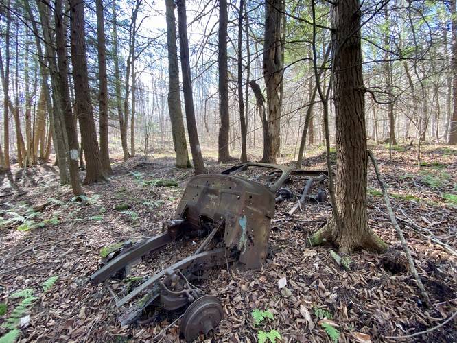
There's not much to note along the service road, except for one rusty and rotting old car located around mile 0.3 off of the trail. It seems this section of the woods was once a dumping spot for locals. Despite the state forest trail map, a portion of the land to the west of the service road is technically private property.
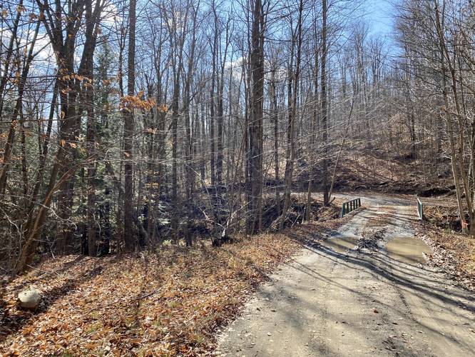
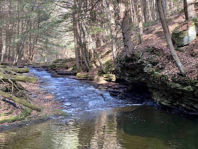
This trail follows the service road until it reaches Rattlesnake Creek which has a driveable bridge that crosses the creek. Here, I hiked along the hillside just above Rattlesnake Creek. By hiking downstream along Rattlesnake Creek, hikers will reach the orange blazes of the Mid State Trail after about 0.15-miles or so.
Mid State Trail Junction - Rattlesnake Creek Falls
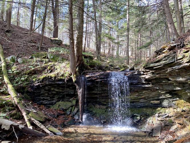
At the Mid State Trail, take a left-hand turn to head uphill to a viewing point of the top of Rattlesnake Creek Falls (aka Rattlesnake Falls). This hillside is very dangerous, steep, and leads down to a 10-foot tall rock ledge below that slope. If you do not wish to take any risks, stay along the Mid State Trail and follow it down the hillside.
Babb Creek Falls
As the Mid State Trail winds its way down the hillside, hikers will reach Babb Creek and a semi-sketchy section of hillside that leads north. If you hike this hillside - carefully - you can make your way to Babb Creek Falls which is a ~8-foot tall slide fantail waterfall. At the base of Babb Creek Falls is a nice pool where brook trout can be found swimming about.
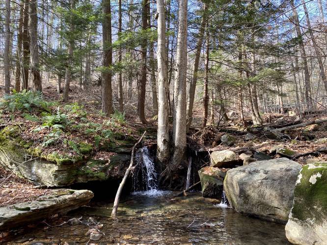
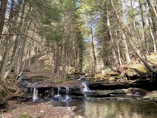
After visiting Babb Creek Falls, hikers will head back to the Mid State Trail to continue hiking downstream alongside Babb Creek. Just before reaching the creek junction of Babb Creek and Rattlesnake Creek, hikers will find a small waterfall along Babb Creek. Now, if you hike another 15 or 20-feet to the creek junction, hikers will find yet another waterfall (4th waterfall). That waterfall is about 3 feet tall, but approximately 25 or 30-feet wide in total as it spans the entire width of Babb Creek. Both lower waterfalls are unnamed, but simply labeled "Lower Babb Creek Falls" respectively on our map.
Rattlesnake Falls / Rattlesnake Creek Falls
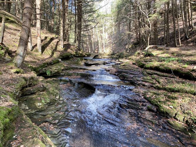
After visiting the creek junction waterfalls, hikers will want to hike upstream along Rattlesnake Creek. Depending on the time of the year, this may not be a good idea if the water level is very high. If the water level allows for easy creek crossing, hikers will want to cross Rattlesnake Creek at the main junction of Babb Creek and Rattlesnake Creek. Hike upstream for approximately 0.1 miles before crossing the creek once again. Finally, hikers can make their way up to the 10-foot tall ledge area next to Rattlesnake Falls to get an awesome view of the waterfall. Rattlesnake Falls cascades down about 10-feet in a free-fall, making it the tallest of the four waterfalls along this hike.
Hiking Back
After visiting Rattlesnake Falls / Rattlesnake Creek Falls, hikers will hike back the identical route. Also note that if you stay on the Mid State Trail, it should meet up with Reese Road. So if you do not want to hike through the woods without a trail, you can hike that way as well.
Additional Waterfalls
Hikers can also explore Sand Run Falls if they hike across Babb Creek and head east for approximately 0.3-miles or less.
Camping and Backpacking
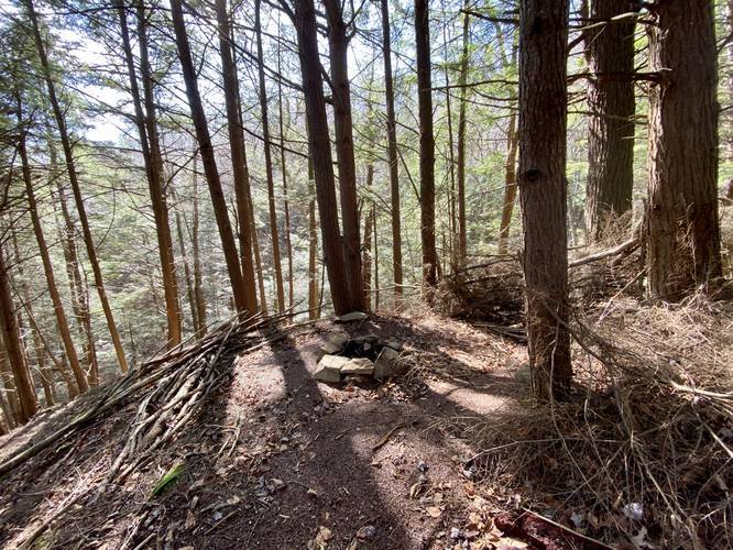
Backpackers will find a campsite along the Mid State Trail near the waterfalls, but it's so small that you can only hang a hammock up here. There's a small fire pit to use as well.
Parking
The only place to find parking here is along a tiny turnout at the junction of South Elk Run Road in Wellsboro, PA. This turnout, according to the Tioga County Property Maps, is private land - so park at your own risk! Hikers should note that there are no designated parking areas for this hike and that parking near the trailhead is all along private property. I did not post this hike to encourage folks to park here, but if literally no one else is around, it won't hurt anyone to leave your car at the turnout for a short period of time. If you arrive to find others have already parked here, consider doing a different waterfall hike like the Sand Run Falls Trail which is only a few miles down the road.
Warning - Rattlesnakes
During the warmer months - April through September, hikers may find Timber Rattlesnakes along this hike. The tend to den inside of rocky ledges and cliffs. Hiking up Rattlesnake Creek, during November was fine, but I noticed several large rocky outcroppings where snakes may claim as their dens. Watch your footing and bring trekking poles to help with distance between yourself and rattlers during warm months.
Blaze Color
As of November 2020, the blaze colors are as follows: blue/red along Reese Road, orange along the Mid State Trail. The blaze color listed here is blue.
Important Private Land Note: The tiny parking turnout and the land off of the service road (for the first 0.3-miles of the hike) is technically private land. Please respect all land owners and do not park near the trailhead if there are other cars around. Park at your own risk and do not leave your vehicle for too long. With regard to backpacking, do not use this hiking guide to reach these waterfalls since long-term parking is not recommended. Please consider using the Sand Run Falls Trail guide instead; however, hikers will need to stay on the Mid State Trail beyond Sand Run Falls heading west to reach these waterfalls.
Trails
This hike follows several trails: Reese Road (service road), Mid State Trail.
Hike Description
Hikers will begin by hiking down the service road, labeled Reese Road on the Tioga State Forest trail map. After passing the yellow gate, the trail levels out and follows a mostly-flat grade while it meanders south through the woods alongside Babb Creek to the east.
There's not much to note along the service road, except for one rusty and rotting old car located around mile 0.3 off of the trail. It seems this section of the woods was once a dumping spot for locals. Despite the state forest trail map, a portion of the land to the west of the service road is technically private property.
This trail follows the service road until it reaches Rattlesnake Creek which has a driveable bridge that crosses the creek. Here, I hiked along the hillside just above Rattlesnake Creek. By hiking downstream along Rattlesnake Creek, hikers will reach the orange blazes of the Mid State Trail after about 0.15-miles or so.
Mid State Trail Junction - Rattlesnake Creek Falls
At the Mid State Trail, take a left-hand turn to head uphill to a viewing point of the top of Rattlesnake Creek Falls (aka Rattlesnake Falls). This hillside is very dangerous, steep, and leads down to a 10-foot tall rock ledge below that slope. If you do not wish to take any risks, stay along the Mid State Trail and follow it down the hillside.
Babb Creek Falls
As the Mid State Trail winds its way down the hillside, hikers will reach Babb Creek and a semi-sketchy section of hillside that leads north. If you hike this hillside - carefully - you can make your way to Babb Creek Falls which is a ~8-foot tall slide fantail waterfall. At the base of Babb Creek Falls is a nice pool where brook trout can be found swimming about.
After visiting Babb Creek Falls, hikers will head back to the Mid State Trail to continue hiking downstream alongside Babb Creek. Just before reaching the creek junction of Babb Creek and Rattlesnake Creek, hikers will find a small waterfall along Babb Creek. Now, if you hike another 15 or 20-feet to the creek junction, hikers will find yet another waterfall (4th waterfall). That waterfall is about 3 feet tall, but approximately 25 or 30-feet wide in total as it spans the entire width of Babb Creek. Both lower waterfalls are unnamed, but simply labeled "Lower Babb Creek Falls" respectively on our map.
Rattlesnake Falls / Rattlesnake Creek Falls
After visiting the creek junction waterfalls, hikers will want to hike upstream along Rattlesnake Creek. Depending on the time of the year, this may not be a good idea if the water level is very high. If the water level allows for easy creek crossing, hikers will want to cross Rattlesnake Creek at the main junction of Babb Creek and Rattlesnake Creek. Hike upstream for approximately 0.1 miles before crossing the creek once again. Finally, hikers can make their way up to the 10-foot tall ledge area next to Rattlesnake Falls to get an awesome view of the waterfall. Rattlesnake Falls cascades down about 10-feet in a free-fall, making it the tallest of the four waterfalls along this hike.
Hiking Back
After visiting Rattlesnake Falls / Rattlesnake Creek Falls, hikers will hike back the identical route. Also note that if you stay on the Mid State Trail, it should meet up with Reese Road. So if you do not want to hike through the woods without a trail, you can hike that way as well.
Additional Waterfalls
Hikers can also explore Sand Run Falls if they hike across Babb Creek and head east for approximately 0.3-miles or less.
Camping and Backpacking
Backpackers will find a campsite along the Mid State Trail near the waterfalls, but it's so small that you can only hang a hammock up here. There's a small fire pit to use as well.
Parking
The only place to find parking here is along a tiny turnout at the junction of South Elk Run Road in Wellsboro, PA. This turnout, according to the Tioga County Property Maps, is private land - so park at your own risk! Hikers should note that there are no designated parking areas for this hike and that parking near the trailhead is all along private property. I did not post this hike to encourage folks to park here, but if literally no one else is around, it won't hurt anyone to leave your car at the turnout for a short period of time. If you arrive to find others have already parked here, consider doing a different waterfall hike like the Sand Run Falls Trail which is only a few miles down the road.
Warning - Rattlesnakes
During the warmer months - April through September, hikers may find Timber Rattlesnakes along this hike. The tend to den inside of rocky ledges and cliffs. Hiking up Rattlesnake Creek, during November was fine, but I noticed several large rocky outcroppings where snakes may claim as their dens. Watch your footing and bring trekking poles to help with distance between yourself and rattlers during warm months.
Blaze Color
As of November 2020, the blaze colors are as follows: blue/red along Reese Road, orange along the Mid State Trail. The blaze color listed here is blue.