The Ramsey Vista Pipeline Hike at Tiadaghton State Forest near Ramsey, Pennsylvania is a difficult 4.6-mile out-and-back hike that leads up a steep pipeline, with breathtaking views of the PA Grand Canyon, and reaches the stunning overlook at the Ramsey Vista at the top of the mountain.
Timber Rattlesnakes: This area is home to the Timber Rattlesnake which can be found roaming the forest floor between the end of April and early October each year. Be on the lookout and give any rattlers you find plenty of space. To avoid them altogether, consider hiking this pipeline during cold months or in the winter.
Natural Gas Pipeline: This hike follows a natural gas pipeline, which have been known to erupt without warning. While extremely-rare, and likely would not happen, it's good to know this before heading out so you can make educated choices for yourself.
Trails
This hike follows the Pine Creek Trail (rail trail), MST (Mid-State Trail), and a natural gas pipeline (off-trail).Skip the Hike (Drive-up View)
If you don't want to hike to this view, you can actually just drive right to it... which is still well-worth the exploration if you don't want to explore by foot or physically can't. To get to this view by car, simply check out our Ramsey Vista (Dead End Vista 3) guide.Bushwhack-style Hiking
Please note that this hike is meant for the experienced off-trail hiker as the natural gas pipeline provides no defined trail to follow. Instead, you'll be hiking off-trail along the pipeline to reach the top of the mountain. Along the way are several very-steep uphill pitches where you'll find thorn bushes, prickers, tall grass, and loose rocks along the way. Some rock ledges along the pipeline even have signs of rockfall, and while this is a very minor danger, it's worth noting.Hiking to Ramsey Vista
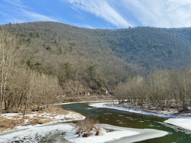
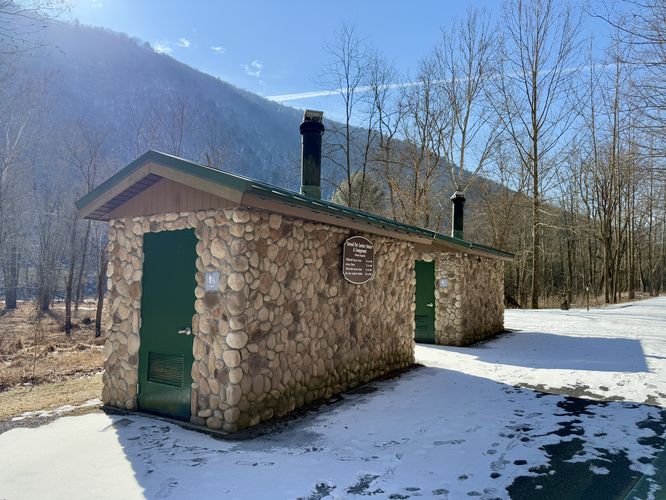
The hike to Ramsey Vista starts in the middle of Ramsey, PA at the small parking lot for the Pine Creek Trail (rail trail). Hikers will simply follow the trail as it leads south. First up along the trail is the old railroad bridge that spans Pine Creek. Here, you'll find nice views of the mountainous gorge, of the PA Grand Canyon, that surround the creek. The trail will pass the Stone Cutter Vista Loop, a popular day hike (and a personal favorite of mine), which is also included in the Pine Creek Pinnacles hiking challenge, located around mile 0.37. Continuing down the trail, you'll then pass the old "Comfort Station" stop along the trail where you'll now find restrooms.Mid-State Trail Junction - Mile 1.3
The hike down the Pine Creek Trail continues further until you reach mile 1.3 where you'll find the Mid State Trail junction. Here, you'll take a right-hand turn onto the MST. It's easy to miss, so be on the lookout or download offline maps in the MyHikes app before you head out (very-little cell service here as of 2025). Once on the MST, follow the trail into the forest and then hike down to Bonnell Run, located just a few-hundred feet from the junction. Cross the creek (Bonnell Run) and then follow the orange blazes of the MST up 2 switchbacks to reach the pipeline.Hiking the Pipeline - Mile 1.5 to 2.3
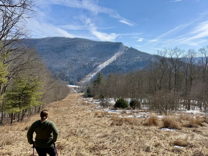
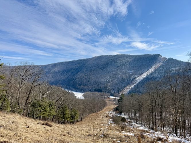
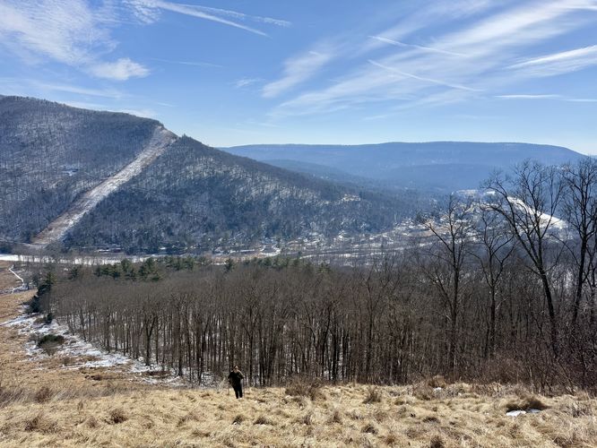
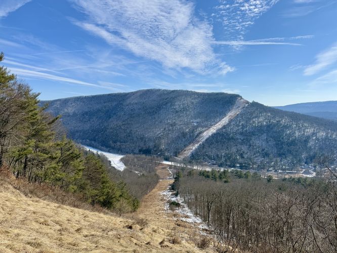
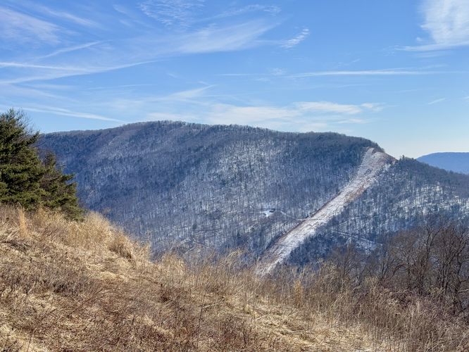
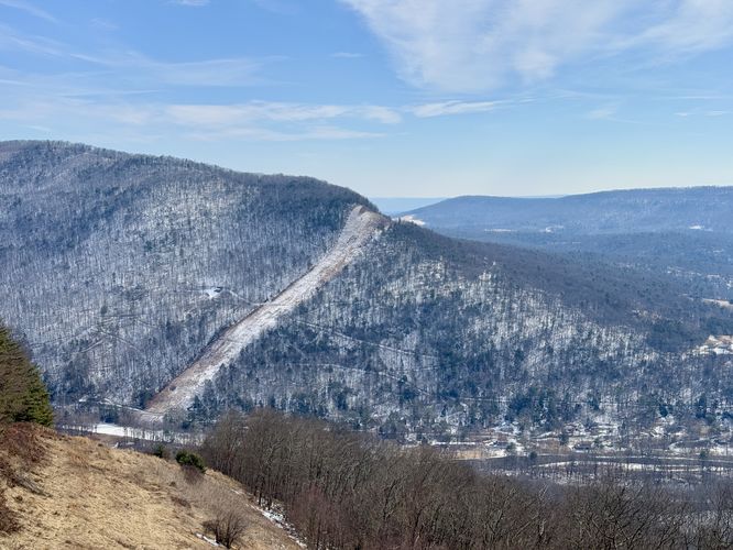
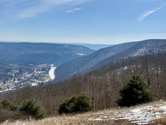
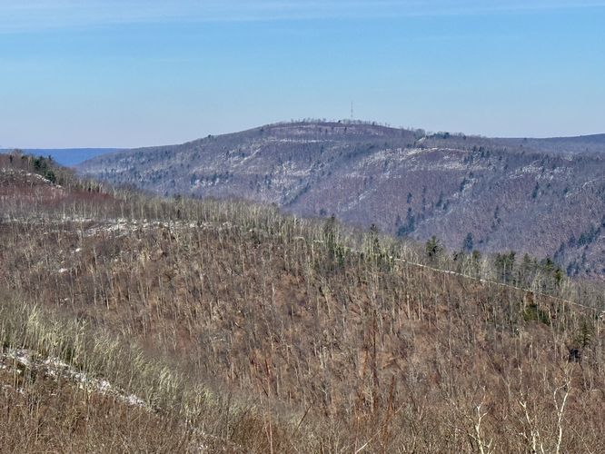
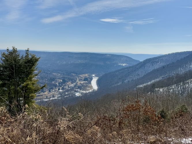
Once on the pipeline, the hike up to the top of the mountain is fairly straight-forward— simply follow the pipeline to the top. From the bottom of the pipeline, you'll notice Houselander Mountain's southern slopes and pipeline staring you down, with a reminder that the hike to the top will be difficult. Things to note along the way though, there are at least three very-steep uphill climbs where trekking poles seriously help both on the uphill and downhill, there are many low-growing pricker bushes scattered throughout, and there are several spots with large rocks littered in the tall grass. Oh, and if you hike this during a warm month, the grass might be very tall and may hike rattlesnakes! The views from the pipeline are awesome though and they make-up for the difficult hike as you can take breaks and enjoy Houselander Mountain, located across the way with Pine Creek cutting through the valley below. Once you reach high enough on the pipeline, you'll start to get more views of surrounding mountains toward Jersey Shore, PA like Short Mountain.Ramsey Vista - Mile 2.3
Once you reach the top of the pipeline, you'll be standing on Dead End Road #3 / Ramsey Vista. Note that there are really two main views from this view. The first view you'll find is from the pipeline where you can peer southward toward Jersey Shore, PA with views of Houselander Mountain and Pine Creek. If you walk the road northward for a couple-hundred feet, you'll reach the Ramsey portion of the Ramsey Vista. Here, you'll notice Houselander Mountain as it wraps around the hamlet of Ramsey, the mountain knob along the Stone Cutter Vista Loop, and Huntley Mountain to name a few. You'll also find another south-facing view of Pine Creek as it winds through the valley at the very end of the PA Grand Canyon.Hiking Out - Mile 2.3 to 4.6
The hike out is, once again, straight forward. Unfortunately there are no public trails or roads that connect back to the Pine Creek Trail from here. So if you hated the hike up, you might not really enjoy the hike back down the pipeline. To be fair, I thought the hike down the pipeline was easier and trekking poles made it so; however, you must be careful to not trust the puffs of grass that sometimes have or do not have solid surfaces below... you can twist an ankle pretty easily. The hike down the pipeline, I thought, was great since you get views of Houselander Mountain the entire way. For folks who have hiked up to the top of that mountain, it's a bit of a "full circle" moment to stare back at what you once accomplished. Once you reach the MST, follow that across Bonnell Run, to reach the Pine Creek Trail. Hike the Pine Creek Trail north back to parking to complete this difficult but beautiful 4.6-mile out-and-back hike through Pennsylvania's Grand Canyon.Parking
Hikers will find a small parking lot at the coordinates provided, located in the hamlet of Ramsey, PA at the Pine Creek Trail (rail trail) trailhead. The lot is large enough to fit less than 10 vehicles as of February 2025.Pets
Dogs are allowed if leashed.Warnings
Bushwhacking: This hike leads along a natural gas pipeline that provides no official trail. The pipeline may be overgrown, full of thorns and prickers, rocks, and even possible Rattlesnakes during warm months.Timber Rattlesnakes: This area is home to the Timber Rattlesnake which can be found roaming the forest floor between the end of April and early October each year. Be on the lookout and give any rattlers you find plenty of space. To avoid them altogether, consider hiking this pipeline during cold months or in the winter.
Natural Gas Pipeline: This hike follows a natural gas pipeline, which have been known to erupt without warning. While extremely-rare, and likely would not happen, it's good to know this before heading out so you can make educated choices for yourself.