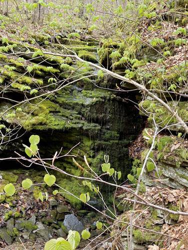
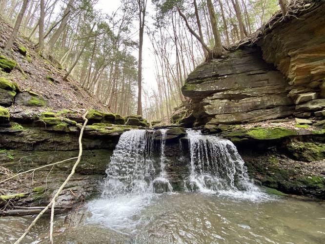
This section of the Pine Island Trail at Tioga State Forest in Morris, Pennsylvania is a difficult 4-mile out-and-back hike that leads to a beautiful but dangerous-to-get-to waterfall, Pine Island Run Falls. Pine Island Run Falls (aka Pine Island Falls) is about 8-feet tall and about 10 to 12-feet wide.
Warning
Hikers must note that this trail requires getting your feet wet, pushing through overgrown sections of trail, and hiking along a sketchy rock ravine to reach the waterfall, with plenty of places to fall and get hurt. Hike at your own risk and bring proper footwear.
Trail Route
The trail begins at an unmarked trailhead located near our trailhead and parking coordinates provided. The trail immediately heads downhill at a fairly steep grade for about a half-mile. This section of the hike is the most difficult in terms of elevation change and going downhill is more difficult here than anticipated, so trekking poles help tremendously.
Once the trail approaches Pine Island Run creek, it will hit a hairpin junction with another trail. This hairpin turn appears to lead down to a large campsite along the creek. Here, hikers will want to stay straight and hike downstream along Pine Island Run and skip the hairpin turn.
Not long after the hairpin junction, hikers will reach an area along the creek with cliffs that line Pine Island Run for about 50-feet and are approximately 15-feet tall. Here, the trail will cross Pine Island Run and will do so several times after this - about 6 times in total.
Along Pine Island Run, even before the first creek crossing, are several very short but beautiful waterfalls. Some of which are 10-feet long, but 2-feet tall slide waterfalls. Others are scenic 2-foot tall waterfalls. Parts of the creek bed are large colorful bedrock - sometimes a shade of red mixed with gray, which makes for a very interesting and scenic hike.
The trail between the first creek crossing and the main falls is a bit sketchy in places. First, hikers need to be aware of the Timber Rattlesnake, while rare, these creek-side rocks are perfect places for them to sun bathe. Some creek crossings involve slippery bedrock footings.
The trail will eventually lead into yet another ravine-like area where Pine Island Run has carved away the bedrock at your feet. The waterfall is not too far from this section, maybe about 300-feet away at best.
Closest to the main waterfall, the hike becomes more scenic but also more dangerous. The trail is essentially non-existent and hikers must choose their own route along the right-hand side (north side) of the creek to reach the waterfall. Some sections of the ravine are exposed wet rock with little-to-no footing where you could easily fall over 5-feet down into the rushing creek. During the Spring, deep sections of the creek and the current could be a deadly combination.
Not long after making your way through the sketchy ravine section of the trail, hikers will finally reach the main destination of this trail: Pine Island Run Falls (aka Pine Island Falls). The path to reach the waterfall is yet another exposed wet rock climb downhill, about 8-feet. At the base of the waterfall, take your pictures and enjoy the scenery before hiking back.
Parking
Hikers can find parking at the coordinates provided. The lot is large enough to fit about 3 vehicles, max.
Dangers
This waterfall should only be hiked by experienced hikers with proper footwear. Some dangers hikers face along this trail are the possibility to finding Timber Rattlesnakes along the rocks in the creek, very dangerous rock ravine traversing, and overgrowth along the trail. Hikers should bring an offline mapping device and it's recommended to hike this waterfall when the leaves are not on the trees so you can see where the trail goes. Hike at your own risk.
Camping and Backpacking
Backpackers will find a large campsite off of the hairpin turn trail about 0.5-miles downhill from the parking lot. Please follow all State Forest rules and regulations before planning to camp off of this trail.
Difficulty
For the most part, this trail is listed as "hard" or "difficult" because of the sketchy sections of trail that are dangerous along with the steep grade closest to the parking lot. Hiking up and down the steep grade is not easy in either direction.
Pets
Dogs are allowed if leashed. Please note that the trail becomes more dangerous closer to the main waterfall and dogs should be kept back from the rock ledges.
Blaze Color
Hikers must note that this trail does not follow any blaze colors, which makes this hike even more challenging.
Reaching Pine Creek and the Pine Creek Trail
When we mapped this, we brought our small dog Jax with us. Once we reached the main waterfall, we realized we could not continue on any further. This trail is supposed to reach the Pine Creek Trail, approximately 0.5-miles from where this recording ends. Note that the trail is likely just as sketchy between the main waterfall and the Pine Creek Trail since I did not see any formal trail heading down the creek from the waterfall.
Winter Road Conditions
Tioga State Forest does not maintain this road during the winter. Do not attempt driving on this road without proper equipment including snow tires and/or chains unless the road is clear. High wind storms may also cause trees to fall across the road, making the road impassible. If you plan to visit during the winter, plan accordingly.