Prepare for a journey of artistic discovery and stunning natural beauty at the Paxmal in Walenstadt, Switzerland. High above the crystal-clear turquoise waters of Lake Walen (Walensee), this monumental art installation offers a serene escape and panoramic views of the Glarus Alps.
The Paxmal Trail is an easy 1 km (0.6 mile) out-and-back hike suitable for most visitors, leading you directly to the vibrant frescos and powerful stone architecture created by artist Karl Bickel between 1924 and 1949. Often described as a "Temple of Peace," the Paxmal is a lesser-known Swiss gem that perfectly blends art, philosophy, and the breathtaking Swiss landscape. Plan your visit today to experience this inspiring site and its message of peace and human development.
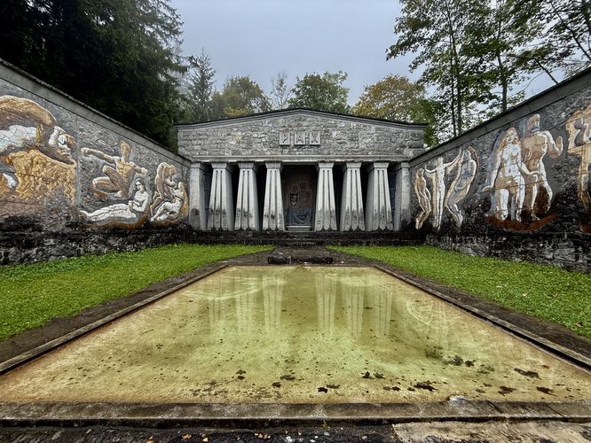
In the center of the Paxmal sits a reflection pool and if you walk into the back of the building, you'll enter a room with tall ceilings and more frescoes, Sitting at the very back-center of the Paxmal is an elderly couple sitting side-by-side, depicting the later stages of human life after experiencing youth, meeting, children, struggles, and religious awakenings.
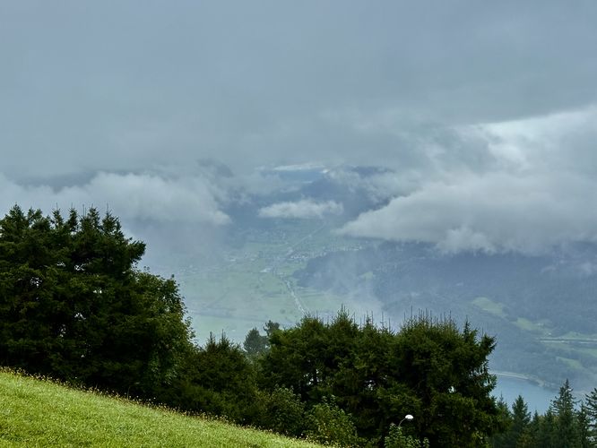
If you arrive on a clear day, the views from the Paxmal are unmatched around Walensee (Lake Walen) and from the front of the building, looking north, are alpine mountains that tower overhead. Unfortunately for me, when I showed up in mid-September 2025, the clouds covered all of the views but the Paxmal was still well-worth exploring!
Visitors will find a large parking lot at the coordinates provided (47.141538, 9.266034), next to the Paxmal trailhead.
The Paxmal Trail is an easy 1 km (0.6 mile) out-and-back hike suitable for most visitors, leading you directly to the vibrant frescos and powerful stone architecture created by artist Karl Bickel between 1924 and 1949. Often described as a "Temple of Peace," the Paxmal is a lesser-known Swiss gem that perfectly blends art, philosophy, and the breathtaking Swiss landscape. Plan your visit today to experience this inspiring site and its message of peace and human development.
Discover the Paxmal: Walenstadt's Mountainside Art Shrine
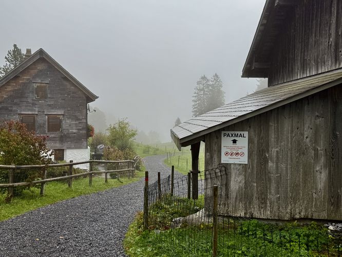
This hike begins near the end of the road, Ruggstrasse, at the designated trailhead located to the east. Here, the trail leads up a short but moderate grade as it passes breathtaking views of the Glarus Alps of Switzerland, on clear days. The trail then follows "Paxmal" signs, located on trail sign posts. You'll pass a private residence near 0.26 km after the trail leads downhill. Hike past the private home and follow the trail as it leads alongside the moss-covered stone walls of the Paxmal.Exploring the Paxmal - 0.47 km
Finally, the stone-paved trail curves around a bend and reaches the Paxmal near 0.47 km from the trailhead. Here, you'll find the stunning architecture of the Paxmal with painted frescoes that line its walls. The frescoes tell a story of humanity and its development. The left (west) side of the Paxmal is all about early human life. It shows a human couple — how they exist, how they grow and develop, and themes of love and having children. The right (east) side, focuses on the spiritual journey: the figures are awakened, they're struggling, but they're always continuing to grow.In the center of the Paxmal sits a reflection pool and if you walk into the back of the building, you'll enter a room with tall ceilings and more frescoes, Sitting at the very back-center of the Paxmal is an elderly couple sitting side-by-side, depicting the later stages of human life after experiencing youth, meeting, children, struggles, and religious awakenings.
If you arrive on a clear day, the views from the Paxmal are unmatched around Walensee (Lake Walen) and from the front of the building, looking north, are alpine mountains that tower overhead. Unfortunately for me, when I showed up in mid-September 2025, the clouds covered all of the views but the Paxmal was still well-worth exploring!
Return Hike - 0.5 to 1 km
After exploring the artwork and architecture of the Paxmal, the hike back to parking is simple. Just hike back the way you came in. There will be at least one uphill hike along the way, which does not last long. If you visit on a clear day, you'll find more breathtaking Alps views on the hike out. Return to the parking area and trailhead to wrap up this 1 km (0.6 mile) out-and-back hike to the Paxmal.Parking & Directions: Getting to the Paxmal
For visitors who wish to explore the Paxmal, and for those who plan to drive to the trailhead, you should be aware that the road (Ruggstrasse) that leads there is very narrow, but scenic. Within the last few kilometers of the road, it turns into a one-lane road where only one vehicle can truly fit. There are some small turnouts along the way to allow other vehicles to pass, but the road does not include any guardrails. The views from Ruggstrasse are unmatched and breathtaking, but the driving might be a bit nerve-wracking.Visitors will find a large parking lot at the coordinates provided (47.141538, 9.266034), next to the Paxmal trailhead.