Loading...

❄️ WINTER SALE! 50% OFF on Supporter Accounts — now through January 31st. Unlock a full year of exclusive website & app perks. Learn More.

Panther Top Lookout Tower Hike

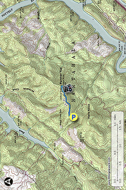
The Panther Top lookout tower is the westernmost tower in North Carolina, located in the southwest corner of the state near Murphy and Hiwassee Lake. Although the mountain appears little more than a hill on a topographic map, the 30-foot tower affords spectacular 270° views of the region. A short, easy walk on gravel FR 85 takes you to the summit of Panther Top (2,293 feet) where you can see the Unicoi, Snowbird, Valley River, Tusquitee, and Georgia Blue Ridge Mountain ranges from the stairs. If you are in the region this easy and accessible hike is a perfect capstone after a day of adventure.

  • Mile 0.0 – Park at the T-junction of gravel FR 85 and FR 85A. From your probable drive approach FR 85 turns left and is gated, with a sign indicating Panther Top Tower is ahead. There is little room to park here other than the grassy shoulders, but since this hike is isolated you most likely will not have an issue parking.
  • Mile 0.7 – FR 85 ends at the grassy aerial marker on the summit of Panther Top (also shown as Panther Knob on some maps). Ironically, even though the lookout tower is the westernmost in the state, it is at the lowest elevation of all publicly accessible lookout towers in the North Carolina mountains (2,293 feet). The 30-foot steel lookout tower was originally built in 1940 and remains in very good condition. Although the top cab is locked, you will have tremendous views from the stairs with the benefit of the wide aerial marker clearing.

    Due north is Hiwassee Lake with the Unicoi Mountains straddling the North Carolina/Tennessee border. To the east is the town of Murphy. Beyond Murphy is the Valley River Valley, surrounded by the Snowbird Mountains to the north and the Valley River Mountains to the south. The Valley River Mountains and Tusquitee Mountains to the east form the expansive Fires Creek Gorge. The broad Hiwassee Valley to the southeast is surrounded by the Georgia Blue Ridge Mountains. You may be able to spot Standing Indian and Rabun Bald in the distant east on clearer days.
  • Mile 1.5 – Hike ends at the gated FR 85 intersection.
By HikingUpward Contributor: Zach Robbins
Explore 5 trails near Murphy, NC

Know Before You Go

  • Panther Top Lookout Tower offers an easily accessible, short 1.5-mile hike on a gravel road to a 30-foot tower with 270° views of surrounding mountain ranges.
  • The tower, though the westernmost in North Carolina and relatively low elevation (2,293 feet), provides impressive vistas from its stairs, including Hiwassee Lake and various mountain ranges.
  • Parking is limited to grassy shoulders at the FR 85 and FR 85A junction, but the hike's isolation typically makes parking manageable.
Interactive topographic map for Panther Top Lookout Tower Hike located in Murphy, NC. Click the "View Map" button to load GPS coordinates and trail markers.
Get directions
Distance
1.5 mi
Difficulty
Easy
Type
Out-and-Back
Est. Time
45 min
Elev. Gain
446'
Rating
0.0
Added
March 20, 2025
Updated
April 06, 2025

Weather Forecast

Tonight
Low 31°F
Mostly Clear
Wednesday
High 50°F
Mostly Cloudy then Rain Showers Likely
Wednesday Night
Low 19°F
Chance Snow Showers
Thursday
High 31°F
Mostly Sunny
Thursday Night
Low 14°F
Mostly Clear
Friday
High 43°F
Mostly Sunny
Friday Night
Low 26°F
Mostly Cloudy then Slight Chance Snow Showers
Saturday
High 40°F
Slight Chance Snow Showers then Mostly Sunny
Saturday Night
Low 14°F
Partly Cloudy
Sunday
High 34°F
Mostly Sunny
Sunday Night
Low 15°F
Mostly Clear
M.L. King Jr. Day
High 44°F
Sunny
Monday Night
Low 19°F
Mostly Clear
Tuesday
High 43°F
Sunny
Loading...
Total Change
414'
Ascent
446'
Descent
446'
Loading...

Download the GPX Data for Offline Use

Supporters get exclusive access to download trail routes to the MyHikes app for offline use. Stay prepared on your adventure, even without an internet connection! Become a Supporter today to unlock this feature and hike with confidence.

Download Panther Top Lookout Tower Hike GPX Data to the MyHikes Mobile App

Features

Vista / Lookout Point
Dogs
Mountain Summit

Points of interest

  1. Parking

    35.063205, -84.107962
  2. Main Trailhead

    35.063207, -84.107906

Safety information

For your own safety: plan ahead, let someone know where you'll be, and hike at your own risk.

Hazards

Snakes (Rattlesnakes, Copperheads, others)
Poison Ivy or Poison Oak

Availability

All seasons

Surface type

Dirt

Trip Reports (Reviews)

Your opinion matters! Be the first to rate this trail.

Ready to help fellow hikers? Add a trip report to share your experience and provide valuable insights for other hikers!

No community routes found. To add your own hike as a Community Route for this Trail guide, leave a Trip Report with an attached GPX file.

Popular categories

Scenic mountain view representing vista trails
Vista trails
Scenic gorge of cascades representing waterfall trails
Waterfall hikes
Rugged mountain terrain representing summit trails
Summit trails
Scenic mountain view representing dog-friendly trails
Dog-friendly
Scenic campsite with a view representing camping trails
Camping trails
Appalachian Trail logo representing A.T. hikes
A.T. hikes

You May Also Like

25 Best Day Hikes in North Carolina - Discover the top 25 best day hikes in North Carolina, from breathtaking waterfalls to mountain peaks. Explore hidden gems, scenic views, and trails suitable for all skill levels, perfect for your next outdoor adventure.
Explore

25 Best Day Hikes in North Carolina

Discover the top 25 best day hikes in North Carolina, from breathtaking waterfalls to mountain peaks. Explore hidden gems, scenic views, and trails suitable for all skill levels, perfect for your next outdoor adventure.

Read
Colorado's Million Dollar Highway - Plan a day's drive adventure along the iconic Million Dollar Highway in Colorado. Explore the best short trails, roadside stops, waterfalls, vistas, ghost towns, and hot springs within a ~6 hour road trip.
Explore

Colorado's Million Dollar Highway

Plan a day's drive adventure along the iconic Million Dollar Highway in Colorado. Explore the best short trails, roadside stops, waterfalls, vistas, ghost towns, and hot springs within a ~6 hour road trip.

Read
Glacier's Going-to-the-Sun Road - Discover the breathtaking beauty of Glacier National Park along the iconic Going-to-the-Sun Road. From stunning roadside stops to picturesque waterfalls and vistas, this engineering marvel offers endless opportunities for exploration.
Explore

Glacier's Going-to-the-Sun Road

Discover the breathtaking beauty of Glacier National Park along the iconic Going-to-the-Sun Road. From stunning roadside stops to picturesque waterfalls and vistas, this engineering marvel offers endless opportunities for exploration.

Read
🍪 We use cookies to learn about site usage and to serve map tiles. You may block cookies manually in the browser. By continuing you agree. Learn more