PA Half Dome - South Ascent at Tiadaghton State Forest in Slate Run, Pennsylvania is a strenuous 3.4-mile out-and-back trek that climbs Half Dome Mountain along the most-difficult path to the summit.
This hike includes views and waterfalls, but is meant only for the experienced hiker as this technically-difficult and dangerous hike poses safety issues for inexperienced hikers both on the mountain and in the mountain hollows. This Half Dome Mountain route is likely the most-difficult hike in all of Pennsylvania as hikers will climb over 2,600-feet in just 3.4-miles.
Trails
This hike follows two named trails: Pine Trail (yellow blazes), Half Dome Mountain Trail / Half Dome Mountain Southeast Ridge Climbing Route (yellow blazes). Please note that I have another guide to hike this mountain which follows the Pine Trail from the North instead (PA Half Dome), which is "easier" than this route, but is still considered a strenuous hike and poses the same dangers while ascending and descending the mountain.
Hike Description
This hike begins along Big Trail Road which is located on the back ridge of Hemlock Mountain and Half Dome Mountain. Hikers will follow the Pine Trail as it leads through mountain laurel and down a rocky mountain hollow to reach Riffle Run creek.
Rock Field - Mile 0.35
Around mile 0.35, hikers will reach a rock field on the mountain where the blazes become a bit more difficult to follow due to blowtown trees that once displayed them. As of September 2022, there was a stone cairn built to help hikers find the next yellow blaze here. Can't find yellow blazes? Simply hike down the mountain along the creek. Note that Riffle Run begins around mile 0.35 too, as the creek begins to spill out of the mountain.
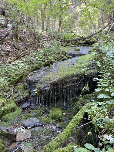
Slippery Rock Falls - Mile 0.45
Around mile 0.45, hikers will pass two large boulders that sit directly in Riffle Run, which I've nicknamed Slippery Rock Falls, as they create a slide waterfall that cascades down the creek. This is a nice spot to take a little break and enjoy the mountainous terrain, boulders, and flowing waters of Riffle Run.
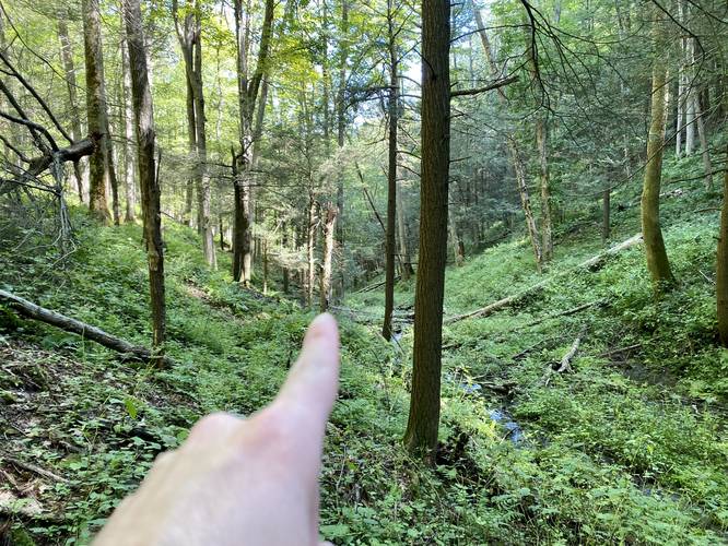
Pine Trail via Riffle Run - Mile 0.5 to 0.8
Once hikers reach mile 0.5, the trail turns to the east as it heads down the mountain hollow and continues to follow Riffle Run. Around mile 0.6, for the next 0.2 miles, the trail heads into the creek. The easiest way to hike the Pine Trail in this section is directly in the creek. Watch for blowdowns, slippery rocks, and other obstacles that can twist your ankles or cause injury. Take this section slow.
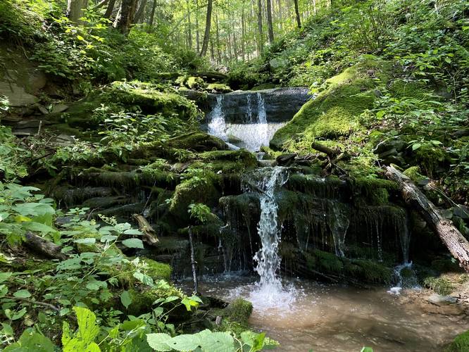
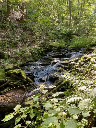
Tranquil Falls & Creek Crossing - Mile 0.8
Around mile 0.8, hikers will reach a series of 3 waterfalls that cascade down Riffle Run at about 3-feet tall, each. Here is where the trail "crosses" Riffle Run back to the northern banks. Take your time and only step on the flat and mossy sections of the bedrock to ensure a safe creek crossing. This is a nice place to take pictures of the waterfalls as well, which I've named "Tranquil Falls". After passing Tranquil Falls, the trail is much easier to follow as it doesn't lead back into the creek.
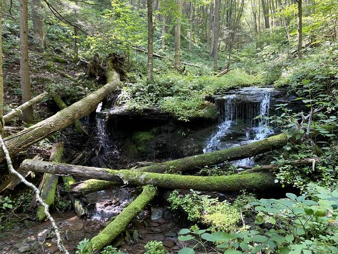
Hanging Rock Falls - Mile 0.95
Along the way down the hollow, after passing Tranquil Falls, hikers will reach the 6-foot tall and 20-foot wide Hanging Rock Falls around mile 0.95. Hanging Rock Falls gets its name from the bedrock that juts out over the creek, approximately 2 - 3 feet deep, causing a free-fall drop of Riffle Run's flow. This section of the hike is pretty cool as well, since there are a couple of smaller, 3-foot cascades, that spill down Riffle Run just downstream of Hanging Rock Falls. Note that to reach Hanging Rock Falls and the smaller cascades downstream, hikers must go off-trail to snap a good photo, but they can be enjoyed from the trail as well.
Turn to Half Dome Mtn - Mile 1.05
Around mile 1.05, hikers will reach a slight bend in the trail as it leads uphill on the north side of Riffle Run. This section of the Pine Trail leads directly to the Half Dome Trail and the beginning of the real ascent on Half Dome Mountain.
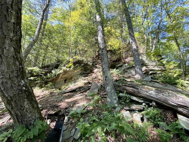
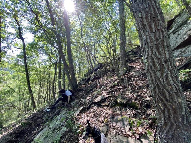
Ascending Half Dome Mountain - Mile 1.1 to 1.6
Finally, at mile 1.1 hikers will begin their ascent up Half Dome Mountain. Between miles 1.1 and 1.6, hikers will be ascend approximately 1,300-feet in just 0.5-miles. After climbing the initial 15-feet, there's a vista that you can enjoy, which is a nice place to take a break before the big climb. This climb should not be taken lightly as there are several sections of rock scrambles where the dirt and rocks can sometimes become loose. The terrain on this trail is extremely steep in some places and very steep throughout. Hikers will find this trail to likely be the most challenging hike in all of Pennsylvania and for good reason. Please note that this mountain should be hiked with trekking poles to ensure your safety. Also note that when descending, it's smart to lower your center of gravity so if you fall, you fall in a way that does not cause injury. Last, Half Dome Mountain is so steep in some places that the friction between your boots and the ground can no longer be trusted, so the mountain often sends hikers down its slopes without much warning.
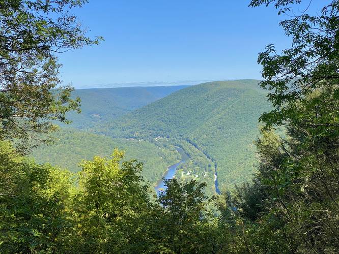
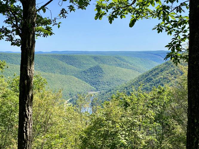
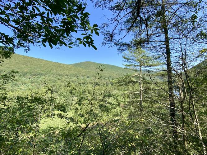
Half Dome Mountain Vistas - Mile 1.66 to 1.7
Once hikers make it to the summit of Half Dome Mountain, they'll be greeted by two stunning vistas of Pine Creek, Slate Run, and the Wolf Run Wild Area, but require a short walk to reach each of them. The southern vista (my personal favorite) has views facing southeast into Pine Creek Gorge (PA Grand Canyon). Keen-eyed hikers may notice the mountain peak that juts up in the canyon with a mountain saddle that swoops low before raising once again to a neighboring mountain. This mountain col is where the Bob Webber Trail traverses around the peaked terrain and through the saddle/col to reach the vista atop the mountain. The northern vista here faces Slate Run with views of the town and the Dragon's Back Trail. As of September 2022, there's a trail registry box where the papers inside were totally ruined from moisture.. not much has changed since my last visit in 2020; however, I forgot to bring my own waterproof box and paper pad for hikers to register... maybe I'll replace it on my next hike here!
Descending Half Dome Mountain - Mile 1.75 to 2.3
The descent of Half Dome Mountain, again, should not be taken lightly since the extremely-steep terrain along the climbing/rock scrambles can be really dangerous. Take your time, lower your center of gravity, and slide on your butt to make the descent safer. Also use your trekking poles to aid in stopping or taking strides down steep terrain. Use caution at all times!
Ascent to Parking - Mile 2.3 to 3.4
The last ascent back to parking is a bit brutal. While the climb is not very difficult, it feels and lasts longer than expected. As stated below, the hike out took almost the same time as the hike up Half Dome Mountain, so plan for a similar-timed trek out. The easier part about hiking up to parking is that you've likely already cut a path through the overgrowth along Riffle Run, so it's a bit easier and faster to traverse. The last section of the climb, which is the worst, is a difficult elevation grade between mile 3 and 3.1 where the hiker must ascent 100-feet in just 0.1 miles, which isn't fun for being so close to the car. Follow the yellow blazes, pay attention to the creek and its obstacles, and the hike out should feel rewarding.
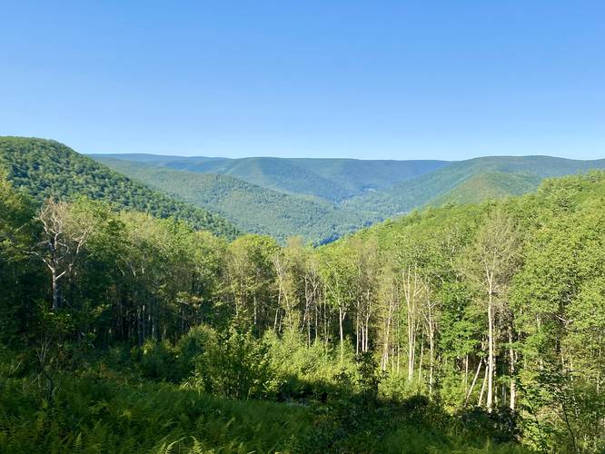
Roadside Vista
After finishing the hike, its best to enjoy one last vista before leaving. Get in your car and drive north (to leave the area), but first stop at the roadside view which provides a stunning scene of Half Dome Mountain, the Dragon's Back, and into Slate Run, Pennsylvania. This last vista is a small reward for completing the entire hike.
Warnings
Off-Trail Creek Hiking: Despite the yellow blazes of the Pine Trail, once hikers reach mile 0.6 in the mountain hollow, the trail follows the creek. Since the trail ends up in the creek, it can be very dangerous for anyone hiking during the Spring when snow melt or heavy rains send large flows of water down the creek. Additionally, traversing the creek with blowdowns, slippery rocks, bedrock, and holes to trap your feet, can be additional dangers to lookout for. For these reasons, it's best to avoid this hike during the Spring or periods of consistent heavy rain.
Stinging Nettles: Along Riffle Run, and almost everywhere in the mountain hollows, stinging nettles grow. This can be a huge pain, literally, to traverse the Pine Trail just to reach the Half Dome Mountain Trail.
Lack of Blazes: The Pine Trail, leading to Half Dome Mountain, follows loosely-defined yellow blazes which can be hard to follow.
Extremely-steep Terrain: Once on Half Dome Mountain, hikers will be faced with extremely-steep terrain where the soil can become loose. When this happens, the mountain tends to send hikers down its slopes. This is no joke and should not be taken lightly, as on this hike, one person did get slightly injured. In fact, we both slid down the mountain for at least 10-feet. This is the same experience I had when initially hiking Half Dome Mountain - gravity will overtake the friction of your boots, thus, it's best to sit on your butt and anticipate the slides on the steepest sections while heading downhill.
Loose, Falling Rocks: Half Dome Mountain has several rock scrambles that are essentially made from slate or shale rock. This can be dangerous because you can accidentally send large chunks of rock down the mountain, potentially heading toward your hiking group. This could also cause you to fall down the mountain with the rock. For this reason, only experienced hikers with scrambling experience should attempt this hike.
Trekking Poles: Hikers should always bring trekking poles for this hike to aid in ascent and descent. Trekking poles may even save yourself from injury due to the insanely-steep terrain.
Avoid Group Hikes: Due to the extremely-steep terrain, it's best to avoid group hikes on this mountain. You never know when you might accidentally send a large chunk of rock down the mountain or accidentally lose your friction and slide into the group behind you. One false move could mean injuries for not just you, but your hiking group. If not hiking solo, it's best to spread your group out while ascending and descending the mountain.
Winter Ascents: Only experienced hikers with proper with gear should attempt this hike when snow and ice are on the ground. Waterproof boots, pants, jacket, ice axe, crampons, layering, and emergency backup gear like a mylar blanket and air-activated hand-warmers are all recommended if attempting this hike in the winter.
Pets
Dogs are allowed if leashed and their waste should be carried out. After the first time I hiked this, I decided I'd never bring Jax (my dog) on this hike, but I ended up bringing him since I couldn't leave him at home. For a 20lbs dog, he crushed it, but it wasn't easy on the steep scrambles. I'd highly recommend not bringing your dog on this hike for various reasons. Only hikers who have a really good working relationship (i.e. hike all the time) with their dogs should even think about bringing them here, as communication with your dog will be huge on the mountain.
Time to Hike
This hike took us 2 hours to ascend Half Dome Mountain. It took us 1 hour and 50 minutes to descent Half Dome in addition to ascending the neighboring mountain back to parking. We hung out at the vista for at least 20 minutes, so hikers should plan 4+ hours for this hike.
No Winter Access
Since this road is not maintained during the winter, this hike is pretty much off-limits from late November through late April as the road will likely have ice build-up, if not covered in deep snow.
Pine Creek Pinnacles (PCP20)
This hike is an accepted alternative route for the Pine Creek Pinnacles hiking challenge. For more information, details, and FAQs, please visit our Pine Creek Pinnacles (PCP20) page.
This hike includes views and waterfalls, but is meant only for the experienced hiker as this technically-difficult and dangerous hike poses safety issues for inexperienced hikers both on the mountain and in the mountain hollows. This Half Dome Mountain route is likely the most-difficult hike in all of Pennsylvania as hikers will climb over 2,600-feet in just 3.4-miles.
Trails
This hike follows two named trails: Pine Trail (yellow blazes), Half Dome Mountain Trail / Half Dome Mountain Southeast Ridge Climbing Route (yellow blazes). Please note that I have another guide to hike this mountain which follows the Pine Trail from the North instead (PA Half Dome), which is "easier" than this route, but is still considered a strenuous hike and poses the same dangers while ascending and descending the mountain.
Hike Description
This hike begins along Big Trail Road which is located on the back ridge of Hemlock Mountain and Half Dome Mountain. Hikers will follow the Pine Trail as it leads through mountain laurel and down a rocky mountain hollow to reach Riffle Run creek.
Rock Field - Mile 0.35
Around mile 0.35, hikers will reach a rock field on the mountain where the blazes become a bit more difficult to follow due to blowtown trees that once displayed them. As of September 2022, there was a stone cairn built to help hikers find the next yellow blaze here. Can't find yellow blazes? Simply hike down the mountain along the creek. Note that Riffle Run begins around mile 0.35 too, as the creek begins to spill out of the mountain.
Slippery Rock Falls - Mile 0.45
Around mile 0.45, hikers will pass two large boulders that sit directly in Riffle Run, which I've nicknamed Slippery Rock Falls, as they create a slide waterfall that cascades down the creek. This is a nice spot to take a little break and enjoy the mountainous terrain, boulders, and flowing waters of Riffle Run.
Pine Trail via Riffle Run - Mile 0.5 to 0.8
Once hikers reach mile 0.5, the trail turns to the east as it heads down the mountain hollow and continues to follow Riffle Run. Around mile 0.6, for the next 0.2 miles, the trail heads into the creek. The easiest way to hike the Pine Trail in this section is directly in the creek. Watch for blowdowns, slippery rocks, and other obstacles that can twist your ankles or cause injury. Take this section slow.
Tranquil Falls & Creek Crossing - Mile 0.8
Around mile 0.8, hikers will reach a series of 3 waterfalls that cascade down Riffle Run at about 3-feet tall, each. Here is where the trail "crosses" Riffle Run back to the northern banks. Take your time and only step on the flat and mossy sections of the bedrock to ensure a safe creek crossing. This is a nice place to take pictures of the waterfalls as well, which I've named "Tranquil Falls". After passing Tranquil Falls, the trail is much easier to follow as it doesn't lead back into the creek.
Hanging Rock Falls - Mile 0.95
Along the way down the hollow, after passing Tranquil Falls, hikers will reach the 6-foot tall and 20-foot wide Hanging Rock Falls around mile 0.95. Hanging Rock Falls gets its name from the bedrock that juts out over the creek, approximately 2 - 3 feet deep, causing a free-fall drop of Riffle Run's flow. This section of the hike is pretty cool as well, since there are a couple of smaller, 3-foot cascades, that spill down Riffle Run just downstream of Hanging Rock Falls. Note that to reach Hanging Rock Falls and the smaller cascades downstream, hikers must go off-trail to snap a good photo, but they can be enjoyed from the trail as well.
Turn to Half Dome Mtn - Mile 1.05
Around mile 1.05, hikers will reach a slight bend in the trail as it leads uphill on the north side of Riffle Run. This section of the Pine Trail leads directly to the Half Dome Trail and the beginning of the real ascent on Half Dome Mountain.
Ascending Half Dome Mountain - Mile 1.1 to 1.6
Finally, at mile 1.1 hikers will begin their ascent up Half Dome Mountain. Between miles 1.1 and 1.6, hikers will be ascend approximately 1,300-feet in just 0.5-miles. After climbing the initial 15-feet, there's a vista that you can enjoy, which is a nice place to take a break before the big climb. This climb should not be taken lightly as there are several sections of rock scrambles where the dirt and rocks can sometimes become loose. The terrain on this trail is extremely steep in some places and very steep throughout. Hikers will find this trail to likely be the most challenging hike in all of Pennsylvania and for good reason. Please note that this mountain should be hiked with trekking poles to ensure your safety. Also note that when descending, it's smart to lower your center of gravity so if you fall, you fall in a way that does not cause injury. Last, Half Dome Mountain is so steep in some places that the friction between your boots and the ground can no longer be trusted, so the mountain often sends hikers down its slopes without much warning.
Half Dome Mountain Vistas - Mile 1.66 to 1.7
Once hikers make it to the summit of Half Dome Mountain, they'll be greeted by two stunning vistas of Pine Creek, Slate Run, and the Wolf Run Wild Area, but require a short walk to reach each of them. The southern vista (my personal favorite) has views facing southeast into Pine Creek Gorge (PA Grand Canyon). Keen-eyed hikers may notice the mountain peak that juts up in the canyon with a mountain saddle that swoops low before raising once again to a neighboring mountain. This mountain col is where the Bob Webber Trail traverses around the peaked terrain and through the saddle/col to reach the vista atop the mountain. The northern vista here faces Slate Run with views of the town and the Dragon's Back Trail. As of September 2022, there's a trail registry box where the papers inside were totally ruined from moisture.. not much has changed since my last visit in 2020; however, I forgot to bring my own waterproof box and paper pad for hikers to register... maybe I'll replace it on my next hike here!
Descending Half Dome Mountain - Mile 1.75 to 2.3
The descent of Half Dome Mountain, again, should not be taken lightly since the extremely-steep terrain along the climbing/rock scrambles can be really dangerous. Take your time, lower your center of gravity, and slide on your butt to make the descent safer. Also use your trekking poles to aid in stopping or taking strides down steep terrain. Use caution at all times!
Ascent to Parking - Mile 2.3 to 3.4
The last ascent back to parking is a bit brutal. While the climb is not very difficult, it feels and lasts longer than expected. As stated below, the hike out took almost the same time as the hike up Half Dome Mountain, so plan for a similar-timed trek out. The easier part about hiking up to parking is that you've likely already cut a path through the overgrowth along Riffle Run, so it's a bit easier and faster to traverse. The last section of the climb, which is the worst, is a difficult elevation grade between mile 3 and 3.1 where the hiker must ascent 100-feet in just 0.1 miles, which isn't fun for being so close to the car. Follow the yellow blazes, pay attention to the creek and its obstacles, and the hike out should feel rewarding.
Roadside Vista
After finishing the hike, its best to enjoy one last vista before leaving. Get in your car and drive north (to leave the area), but first stop at the roadside view which provides a stunning scene of Half Dome Mountain, the Dragon's Back, and into Slate Run, Pennsylvania. This last vista is a small reward for completing the entire hike.
Warnings
Off-Trail Creek Hiking: Despite the yellow blazes of the Pine Trail, once hikers reach mile 0.6 in the mountain hollow, the trail follows the creek. Since the trail ends up in the creek, it can be very dangerous for anyone hiking during the Spring when snow melt or heavy rains send large flows of water down the creek. Additionally, traversing the creek with blowdowns, slippery rocks, bedrock, and holes to trap your feet, can be additional dangers to lookout for. For these reasons, it's best to avoid this hike during the Spring or periods of consistent heavy rain.
Stinging Nettles: Along Riffle Run, and almost everywhere in the mountain hollows, stinging nettles grow. This can be a huge pain, literally, to traverse the Pine Trail just to reach the Half Dome Mountain Trail.
Lack of Blazes: The Pine Trail, leading to Half Dome Mountain, follows loosely-defined yellow blazes which can be hard to follow.
Extremely-steep Terrain: Once on Half Dome Mountain, hikers will be faced with extremely-steep terrain where the soil can become loose. When this happens, the mountain tends to send hikers down its slopes. This is no joke and should not be taken lightly, as on this hike, one person did get slightly injured. In fact, we both slid down the mountain for at least 10-feet. This is the same experience I had when initially hiking Half Dome Mountain - gravity will overtake the friction of your boots, thus, it's best to sit on your butt and anticipate the slides on the steepest sections while heading downhill.
Loose, Falling Rocks: Half Dome Mountain has several rock scrambles that are essentially made from slate or shale rock. This can be dangerous because you can accidentally send large chunks of rock down the mountain, potentially heading toward your hiking group. This could also cause you to fall down the mountain with the rock. For this reason, only experienced hikers with scrambling experience should attempt this hike.
Trekking Poles: Hikers should always bring trekking poles for this hike to aid in ascent and descent. Trekking poles may even save yourself from injury due to the insanely-steep terrain.
Avoid Group Hikes: Due to the extremely-steep terrain, it's best to avoid group hikes on this mountain. You never know when you might accidentally send a large chunk of rock down the mountain or accidentally lose your friction and slide into the group behind you. One false move could mean injuries for not just you, but your hiking group. If not hiking solo, it's best to spread your group out while ascending and descending the mountain.
Winter Ascents: Only experienced hikers with proper with gear should attempt this hike when snow and ice are on the ground. Waterproof boots, pants, jacket, ice axe, crampons, layering, and emergency backup gear like a mylar blanket and air-activated hand-warmers are all recommended if attempting this hike in the winter.
Pets
Dogs are allowed if leashed and their waste should be carried out. After the first time I hiked this, I decided I'd never bring Jax (my dog) on this hike, but I ended up bringing him since I couldn't leave him at home. For a 20lbs dog, he crushed it, but it wasn't easy on the steep scrambles. I'd highly recommend not bringing your dog on this hike for various reasons. Only hikers who have a really good working relationship (i.e. hike all the time) with their dogs should even think about bringing them here, as communication with your dog will be huge on the mountain.
Time to Hike
This hike took us 2 hours to ascend Half Dome Mountain. It took us 1 hour and 50 minutes to descent Half Dome in addition to ascending the neighboring mountain back to parking. We hung out at the vista for at least 20 minutes, so hikers should plan 4+ hours for this hike.
No Winter Access
Since this road is not maintained during the winter, this hike is pretty much off-limits from late November through late April as the road will likely have ice build-up, if not covered in deep snow.
Pine Creek Pinnacles (PCP20)
This hike is an accepted alternative route for the Pine Creek Pinnacles hiking challenge. For more information, details, and FAQs, please visit our Pine Creek Pinnacles (PCP20) page.