Loading...

🎉 Find content tailored to you in the For You tab! Learn More.

Nufenen Pass Overlook

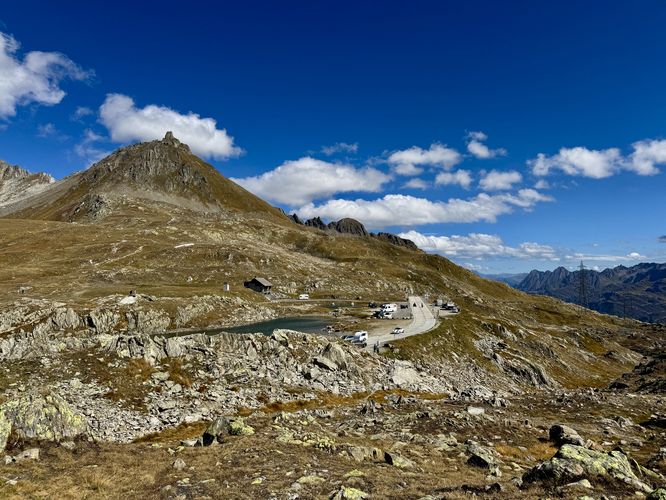
Nufenen Pass, Switzerland's second highest mountain pass, divides the canton of Valais from Ticino and provides some of the most breathtaking panoramic Swiss Alps views. This stunning alpine route is a must-do road trip in Switzerland.

This short, easy 0.7km (0.4 mile) out-and-back hike leads visitors from the main parking area out to a mountainside viewpoint with views of the Griesgletscher, Griessee, the Finsteraarhorn, Lauteraarhorn, and other alpine peaks within the Bernese Alps.

Exploring Nufenen Pass

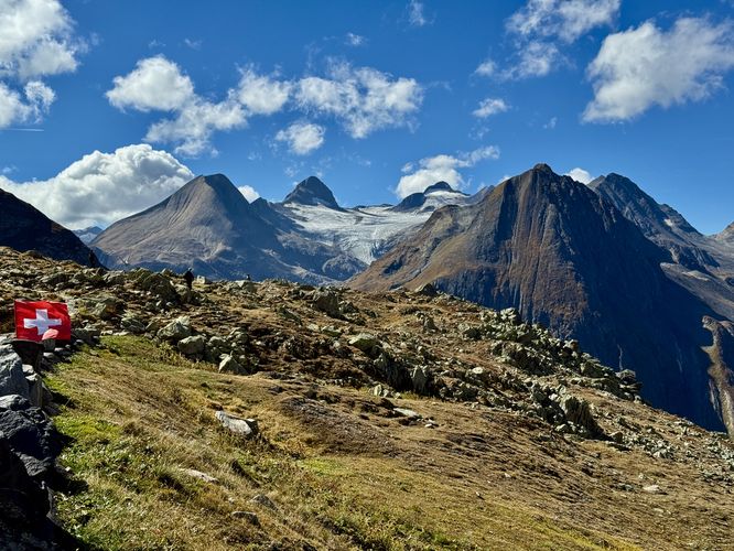
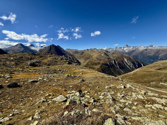
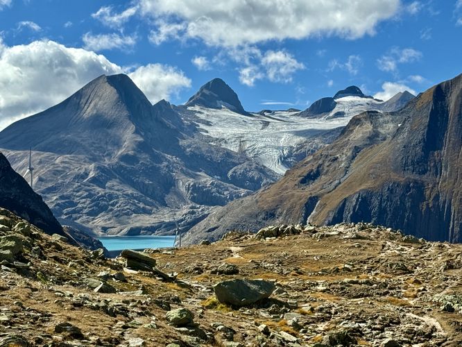
Visitors to Nufenen Pass will find a discrete trailhead located on the southwest side of the main parking lot where this short, family-friendly hike starts. The trail system here is mostly undefined, but following the general path leads to the incredible Griessee viewpoint. This route leads hikers uphill to reach an overlook of Nufenen Pass, the small alpine lake at the top, and a view into the canton of Ticino. After exploring the short hill overlook, the trail then leads southwest along a rocky path to reach a viewpoint where you'll find the dam of Griessee, holding back the glacial melt waters of Griesgletscher. The majestic mountain lake of Griessee is surrounded by alpine peaks like the Fulhorn, Battelmatthorn, and Blinnenhorn.

Panoramic Views of the Bernese Alps (Finsteraarhorn, Lauteraarhorn)

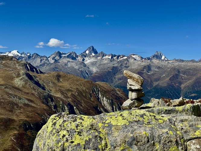
To the west sits a dramatic view of the Bernese Alps where you'll find the jagged Finsteraarhorn on the left-hand side with the Lauteraarhorn on the right. In between, and surrounding these Alpine peaks, are countless other Swiss Alps that sit on the horizon. Below the Finsteraarhorn, visitors will find a glimmer of the Studergletscher as it stretches eastward, filling in the alpine valleys with a river of frozen water.
When done exploring the views of Nufenen Pass, the trail leads right back to the parking lot to complete this short and easy 0.7km out-and-back hike.

When does Nufenen Pass open?

Due to heavy snow, Nufenen Pass is typically closed from November to May. For travelers, expect the road to be open from June through October, but due to changing weather conditions, it may vary. Always check local sources before committing to the drive.

How high is Nufenen Pass?

The summit is at 2,478 meters (8,130 feet) above sea level.

Is Nufenen Pass difficult to drive?

The road is paved but features many hairpin turns. It is generally considered easier than the Susten or Grimsel Passes.

Warning

Elevation sickness: Nufenen Pass sits around 2,500m (8,200 feet) above sea level, which is around where most people will start to feel effects of the altitude. For people who are effected by elevation/altitude sickness easily, you may notice the altitude after driving up the mountain pass.
Explore 12 trails near Obergoms VS, Switzerland

Know Before You Go

  • The Nufenen Pass is the highest paved road entirely within Switzerland at 2,478m (8,130 ft), making it a crucial stop for high-altitude Swiss Alps road trips and connecting the Valais and Ticino Cantons.
  • The route is a short, easy 0.7km hike perfect for all travelers, offering panoramic glacier views of the Griesgletscher, Griessee glacial lake, and iconic peaks like the Finsteraarhorn in the Bernese Alps.
  • Often less crowded than its neighbors (Furka and Gotthard), the Nufenen Pass is a must-drive scenic route but is seasonally closed from typically November to late May/early June due to heavy snow.
Interactive topographic map for Nufenen Pass Overlook located in Obergoms VS, Switzerland. Click the "View Map" button to load GPS coordinates and trail markers.
Get directions
Distance
0.6 km
Difficulty
Easy
Type
Out-and-Back
Est. Time
15 min
Elev. Gain
20m
Rating
5.0
Added
September 20, 2025
Updated
December 14, 2025
Loading...
Total Change
15m
Ascent
20m
Descent
20m
Loading...

Download the GPX Data for Offline Use

Supporters get exclusive access to download trail routes to the MyHikes app for offline use. Stay prepared on your adventure, even without an internet connection! Become a Supporter today to unlock this feature and hike with confidence.

Download Nufenen Pass Overlook GPX Data to the MyHikes Mobile App

Features

Vista / Lookout Point
Dogs

Points of interest

  1. Parking

    46.477499, 8.386333
  2. Main Trailhead

    46.477499, 8.386333
  3. View / Overlook / Vista

    46.477464, 8.386203
    View / Overlook / Vista
  4. View of Finsteraarhorn

    46.477067, 8.385908
    View of Finsteraarhorn

Safety information

For your own safety: plan ahead, let someone know where you'll be, and hike at your own risk.

Availability

Spring, Summer, Fall

Surface type

Dirt

Trip Reports (Reviews)

Rated 5.0 out of 5 based on 2 ratings.

Ready to help fellow hikers? Add a trip report to share your experience and provide valuable insights for other hikers!

0.4 miles / 0.6 km
September 20, 2025
Driving up Nufenen Pass was a bit crazy with a ton of bikers and motorcyclists. Views from the top were amazing and the short hike out to the viewpoints with the Bernese Alps in the distance was well worth the drive to get there.
Hiking
No community routes found. To add your own hike as a Community Route for this Trail guide, leave a Trip Report with an attached GPX file.

Popular categories

Scenic mountain view representing vista trails
Vista trails
Scenic gorge of cascades representing waterfall trails
Waterfall hikes
Rugged mountain terrain representing summit trails
Summit trails
Scenic mountain view representing dog-friendly trails
Dog-friendly
Scenic campsite with a view representing camping trails
Camping trails
Appalachian Trail logo representing A.T. hikes
A.T. hikes

You May Also Like

🍪 We use cookies to learn about site usage and to serve map tiles. You may block cookies manually in the browser. By continuing you agree. Learn more