The North Mountain Vista at Tioga State Forest in Gaines, Pennsylvania is a moderate 0.6-mile out-and-back hike that leads up the northern slopes of Cedar Mountain through a logged area to reach sweeping views that include Deadman Hollow canyon, Mt. Tom, ridges of the PA Grand Canyon, the Wellsboro Airport, and as of 2022, Hillstone Farms.
Hike Description
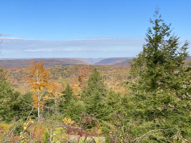
This short hike begins at a large parking turnout located at the coordinates provided which appears to be an old staging area for loggers who would prep trees for transport. This slope of Cedar Mountain appears to have been logged within the last 2-years or so (circa 2020). There's a very old yellow, but rusty-brown, service road gate at the far end of the large parking lot - this is the path to follow. During most of the year, the trail is overgrown with tall grasses, brush, and some thorny bushes scattered. Hikers will make their way up the hill as the logging road immediately ascends this northern slope of Cedar Mountain, but along the way are views facing north which peer into the Deadman Hollow Run canyon - also note the mountain top wind turbines located just to the west of the Deadman Hollow Run area.
Stay Left to Ascend
Just a few-hundred feet into the hike, there's a split in the service road, stay left here to continue heading up the steeper trail. Note that at this turn, the trail will begin to hit large ditches which are likely meant to prevent any motorized vehicles (i.e. ATVs, snowmobiles, etc) from driving on this trail. The ditches are sometimes 3 - 4 feet deep which makes traversing these sections slightly annoying.
North Mountain Vista - Mile 0.18 to 0.3
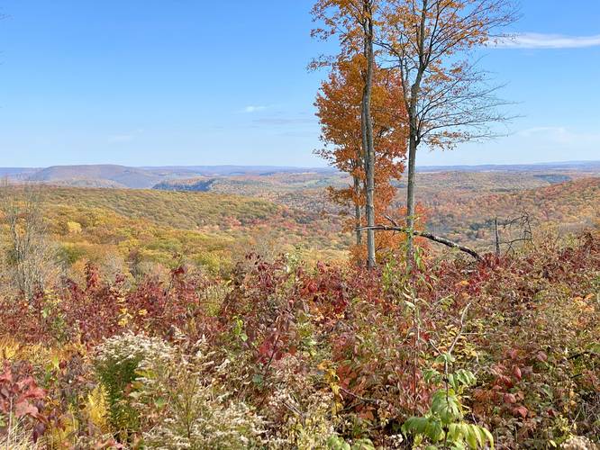
From miles ~0.18 to 0.3, hikers will be presented with several different views, vistas, and vantage points along the trail which are all north-facing. From the top of the hill are some of the better views though. Due-north is the Deadman Hollow Run canyon area, to the right of that is the Ansonia Ridge, to the right of that is a full view of Mt. Tom, and the white hanger buildings of the Wellsboro Airport. Between the airport and Mt. Tom is Round Top Mountain and on its southwestern slopes is the Hillstone Farms property (as of Oct, 2022). To fully enjoy all of the different vantage points and views, hikers will want to meander along the old logging roads on the slope of Cedar Mountain. During Autumn, the grass along the slopes are light-colored, whispy, and extremely fine, which makes for an interesting setting amongst the reds, yellows, and orange foliage that blankets the mountain tops from this view.
Parking
Hikers will find a very large parking lot for this hike at the coordinates provided. It's large enough to fit over a dozen vehicles.
Pets
Dogs are allowed if leashed and their waste should be carried out by the hiker.
Camping & Backpacking
Dispersed / primitive / backcountry camping is permitted within Tioga State Forest; however, no designated campsites were found along this hike. Please follow all state forest rules and regulations if camping here.
Warning
Timber Rattlesnake: While this trail likely doesn't have any Timber Rattlesnake populations living nearby, between the months of April and October, they may be roaming through the forest. Be on the lookout and give any rattler you find plenty of space.
No water: This hike has no water sources for filtering. Hikers should pack in all of their water for this hike despite it being very short.
No Winter Access
Due to the lack of road maintenance, there's no motorized access to reach this view during the winter without a snowmobile. Ice and snow usually shows up at the end of November and can last through mid-April.
Hike Description
This short hike begins at a large parking turnout located at the coordinates provided which appears to be an old staging area for loggers who would prep trees for transport. This slope of Cedar Mountain appears to have been logged within the last 2-years or so (circa 2020). There's a very old yellow, but rusty-brown, service road gate at the far end of the large parking lot - this is the path to follow. During most of the year, the trail is overgrown with tall grasses, brush, and some thorny bushes scattered. Hikers will make their way up the hill as the logging road immediately ascends this northern slope of Cedar Mountain, but along the way are views facing north which peer into the Deadman Hollow Run canyon - also note the mountain top wind turbines located just to the west of the Deadman Hollow Run area.
Stay Left to Ascend
Just a few-hundred feet into the hike, there's a split in the service road, stay left here to continue heading up the steeper trail. Note that at this turn, the trail will begin to hit large ditches which are likely meant to prevent any motorized vehicles (i.e. ATVs, snowmobiles, etc) from driving on this trail. The ditches are sometimes 3 - 4 feet deep which makes traversing these sections slightly annoying.
North Mountain Vista - Mile 0.18 to 0.3
From miles ~0.18 to 0.3, hikers will be presented with several different views, vistas, and vantage points along the trail which are all north-facing. From the top of the hill are some of the better views though. Due-north is the Deadman Hollow Run canyon area, to the right of that is the Ansonia Ridge, to the right of that is a full view of Mt. Tom, and the white hanger buildings of the Wellsboro Airport. Between the airport and Mt. Tom is Round Top Mountain and on its southwestern slopes is the Hillstone Farms property (as of Oct, 2022). To fully enjoy all of the different vantage points and views, hikers will want to meander along the old logging roads on the slope of Cedar Mountain. During Autumn, the grass along the slopes are light-colored, whispy, and extremely fine, which makes for an interesting setting amongst the reds, yellows, and orange foliage that blankets the mountain tops from this view.
Parking
Hikers will find a very large parking lot for this hike at the coordinates provided. It's large enough to fit over a dozen vehicles.
Pets
Dogs are allowed if leashed and their waste should be carried out by the hiker.
Camping & Backpacking
Dispersed / primitive / backcountry camping is permitted within Tioga State Forest; however, no designated campsites were found along this hike. Please follow all state forest rules and regulations if camping here.
Warning
Timber Rattlesnake: While this trail likely doesn't have any Timber Rattlesnake populations living nearby, between the months of April and October, they may be roaming through the forest. Be on the lookout and give any rattler you find plenty of space.
No water: This hike has no water sources for filtering. Hikers should pack in all of their water for this hike despite it being very short.
No Winter Access
Due to the lack of road maintenance, there's no motorized access to reach this view during the winter without a snowmobile. Ice and snow usually shows up at the end of November and can last through mid-April.