The Deadman Hollow Run Trail at Tioga State Forest in Gaines, Pennsylvania is a moderate 4.2-mile out-and-back trail that runs along Deadman Hollow Run and through a coniferous forest.
The trail starts along the Bee Tree Ski Trail and follows it for a few hundred feet - crossing Deadman Hollow Run on a wooden footbridge, then keeping right at the fork in the trail to stay along the Deadman Hollow Run Trail.
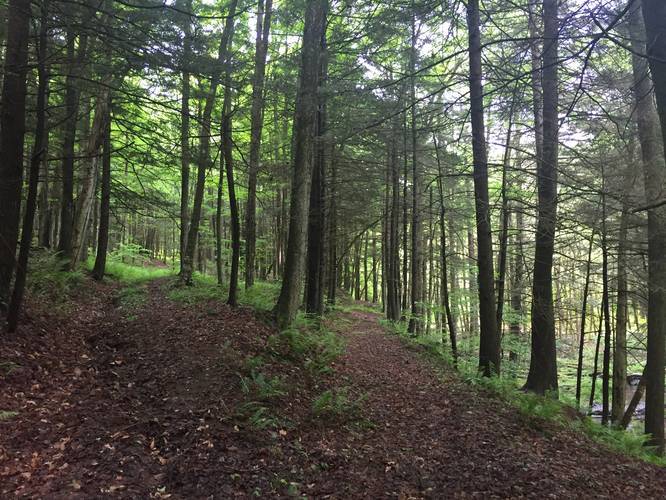
While there is not much to see on this trail, it's generally a nice walk through a pine and evergreen trees. You can also hear Deadman Hollow Run rushing downhill towards Pine Creek throughout most of the hike. There's plenty of moss to find along this trail near the northern trailhead as well as small tributaries that lead downhill into Deadman Hollow Run, so it can be muddy at times.
After approximately 0.6-miles into the hike, the trail will hit another fork - stay left here to continue hiking uphill. If you go right at the fork, you'll reach a dead end.
Further south, around 1.5-miles into the hike, the trail will enter a more overgrown forest (during warmer months) and the trail can be difficult to follow especially since there are no blaze colors to follow. If you can find your way through the overgrowth and along the old service trail, you'll eventually reach Painter Run Road at the southern end of the trail.
Warning: During the warmer months, there can be plenty of overgrowth along the trail, which makes it difficult to find your way. There are no blaze colors, so your best bet is to have an offline-capable tracking device to ensure you're on the right part of the trail. Also note that this GPS track does not fully end at the southern terminus along Painter Run Road, since the trail was so overgrown when this was tracked.
Camping: While there are no campsites along this trail, you can backpack and primitive camp here. There are likely spots to camp along the hillsides on either side of the trail.
Pets: Dogs are allowed if leashed and their waste must be carried out.
Water source: If you use a water filter, you can filter from Deadman Hollow Run right downhill from the trail.
Parking: Parking can be found at the beginning of Freleigh Flat Rd in Gaines at the hairpin turn in the road. There are enough spaces for about 4 cars.
Biking: Mountain biking is allowed on this trail. You may encounter some downed trees from time to time, but the trail is not very rocky or full of roots.
History: This area was logged around 1900 by the O'Connor brothers. One brother was a trapper and on one winter day, he set out to check his taps, but did not return. His body was found in a somewhat decomposed state the following Spring, caught in one of his own bear traps. The hollow in which his body was discovered has been forever referred to, and officially named, Deadman Hollow.
The trail starts along the Bee Tree Ski Trail and follows it for a few hundred feet - crossing Deadman Hollow Run on a wooden footbridge, then keeping right at the fork in the trail to stay along the Deadman Hollow Run Trail.
While there is not much to see on this trail, it's generally a nice walk through a pine and evergreen trees. You can also hear Deadman Hollow Run rushing downhill towards Pine Creek throughout most of the hike. There's plenty of moss to find along this trail near the northern trailhead as well as small tributaries that lead downhill into Deadman Hollow Run, so it can be muddy at times.
After approximately 0.6-miles into the hike, the trail will hit another fork - stay left here to continue hiking uphill. If you go right at the fork, you'll reach a dead end.
Further south, around 1.5-miles into the hike, the trail will enter a more overgrown forest (during warmer months) and the trail can be difficult to follow especially since there are no blaze colors to follow. If you can find your way through the overgrowth and along the old service trail, you'll eventually reach Painter Run Road at the southern end of the trail.
Warning: During the warmer months, there can be plenty of overgrowth along the trail, which makes it difficult to find your way. There are no blaze colors, so your best bet is to have an offline-capable tracking device to ensure you're on the right part of the trail. Also note that this GPS track does not fully end at the southern terminus along Painter Run Road, since the trail was so overgrown when this was tracked.
Camping: While there are no campsites along this trail, you can backpack and primitive camp here. There are likely spots to camp along the hillsides on either side of the trail.
Pets: Dogs are allowed if leashed and their waste must be carried out.
Water source: If you use a water filter, you can filter from Deadman Hollow Run right downhill from the trail.
Parking: Parking can be found at the beginning of Freleigh Flat Rd in Gaines at the hairpin turn in the road. There are enough spaces for about 4 cars.
Biking: Mountain biking is allowed on this trail. You may encounter some downed trees from time to time, but the trail is not very rocky or full of roots.
History: This area was logged around 1900 by the O'Connor brothers. One brother was a trapper and on one winter day, he set out to check his taps, but did not return. His body was found in a somewhat decomposed state the following Spring, caught in one of his own bear traps. The hollow in which his body was discovered has been forever referred to, and officially named, Deadman Hollow.