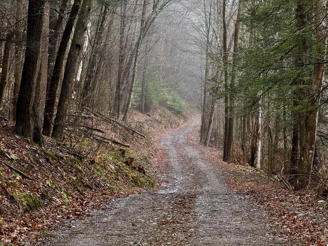
The Mt. Tom Service Road to Vista Trail at Tioga State Forest near Wellsboro, Pennsylvania is a difficult 4.5-mile out-and-back hike that summits Mount Tom and features beautiful views of the northern Pine Creek mountains.
This hike begins at the junction of PA Route 326 and PA Route 6 and follows the service road for the entire length of the hike up to the top of Mount Tom. The trail's grade is moderate for the first 1.25-miles or so, but the last half-mile climb, leading up the mountain, is more steep - hence, the "hard" or "difficult" difficulty level.
On the way up the trail, hikers will pass the yellow-blaze Mt. Tom Loop, which runs the strenuous way up the mountain. Inexperienced hikers should stick to the service road and not attempt the strenuous, very very steep, yellow blazes. Continuing on from that intersection, the vista point is roughly 1.5-miles from that junction.
Once hikers reach the top of the mountain, the trail hits another junction. Here, hikers should take a left-hand turn and follow the flat and easy, red-blazed, trail out to the vista point. Just before the vista point, hikers will see the yellow-blazes that lead down the very very steep trail to complete the Mt. Tom Loop -- however, skip this and take a right-hand turn to head to the lookout point instead.
The hike back follows the same route up to the vista point, unless you dare to hike down the yellow-blazed trail.
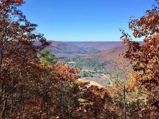
Vista Point
The vista point can be found along the top of the mountain ridge about a half-mile from the Mt Tom summit. The clearing gives hikers a view of the Ansonia Valley, Gaines, and in the distance - Elephant Mountain and a glimpse of the mountains near Galeton, PA. The main view is of the northern Pine Creek mountain range, just north of the PA Grand Canyon - or, technically, the beginning of the canyon.
Parking
Hikers can find parking at the large turnouts at the coordinates provided. More specifically, the parking area is located on both sides of PA Route 362 next to the intersection with PA Route 6. There's enough space to fit a dozen cars on each side, but this area is a popular truck turnout spot and a parking area for fisherman (along Pine Creek).
Pets
Dogs are allowed if leashed and their waste must be carried out by the hiker.
Camping
While this trail technically does not have any designated campsites, backpacking and dispersed camping is allowed here. Please read into the state forest's rules and regulations before planning a trip.
Biking
Mountain biking is technically allowed along this service road. It may or may not be allowed along the ridge trail though.
This hike begins at the junction of PA Route 326 and PA Route 6 and follows the service road for the entire length of the hike up to the top of Mount Tom. The trail's grade is moderate for the first 1.25-miles or so, but the last half-mile climb, leading up the mountain, is more steep - hence, the "hard" or "difficult" difficulty level.
On the way up the trail, hikers will pass the yellow-blaze Mt. Tom Loop, which runs the strenuous way up the mountain. Inexperienced hikers should stick to the service road and not attempt the strenuous, very very steep, yellow blazes. Continuing on from that intersection, the vista point is roughly 1.5-miles from that junction.
Once hikers reach the top of the mountain, the trail hits another junction. Here, hikers should take a left-hand turn and follow the flat and easy, red-blazed, trail out to the vista point. Just before the vista point, hikers will see the yellow-blazes that lead down the very very steep trail to complete the Mt. Tom Loop -- however, skip this and take a right-hand turn to head to the lookout point instead.
The hike back follows the same route up to the vista point, unless you dare to hike down the yellow-blazed trail.
Vista Point
The vista point can be found along the top of the mountain ridge about a half-mile from the Mt Tom summit. The clearing gives hikers a view of the Ansonia Valley, Gaines, and in the distance - Elephant Mountain and a glimpse of the mountains near Galeton, PA. The main view is of the northern Pine Creek mountain range, just north of the PA Grand Canyon - or, technically, the beginning of the canyon.
Parking
Hikers can find parking at the large turnouts at the coordinates provided. More specifically, the parking area is located on both sides of PA Route 362 next to the intersection with PA Route 6. There's enough space to fit a dozen cars on each side, but this area is a popular truck turnout spot and a parking area for fisherman (along Pine Creek).
Pets
Dogs are allowed if leashed and their waste must be carried out by the hiker.
Camping
While this trail technically does not have any designated campsites, backpacking and dispersed camping is allowed here. Please read into the state forest's rules and regulations before planning a trip.
Biking
Mountain biking is technically allowed along this service road. It may or may not be allowed along the ridge trail though.