Mt. Tom Falls at Tioga State Forest near Wellsboro, Pennsylvania is a moderate 0.8-mile out-and-back bushwhack and waterfall creek hike that features a lesser-known 3-foot tall and 15-foot wide waterfall, Mt. Tom Falls.
Hike Description
This hike begins at the Darling Run parking area for the Pine Creek Trail along PA-362. Hikers will cross PA-362 to find the Mt. Tom Trail (Mount Tom). Here, instead of following the yellow blazes, hikers will head straight alongside the creek, while bushwhacking through trees (as of January 2022). Through the bushwhack appears to be an old log slide grade that hikers can follow to stay out of the creek for a short while.
Eventually the hillsides along the creek become steeper, so hikers will be somewhat forced to traverse the creek itself. This creek hike is not very difficult, but can pose hazards such as the Timber Rattlesnake during warmer months.
Mt. Tom Falls - Mile 0.3
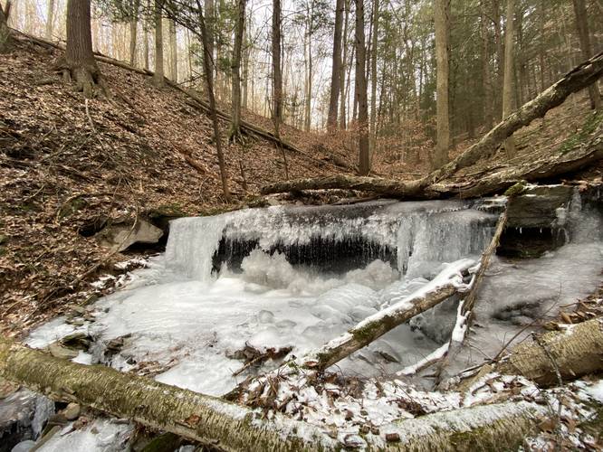
Around mile 0.3, hikers will reach Mt. Tom Falls as it cascades down a 3-foot tall and 15-foot wide rock ledge. The rock ledge appears to overhang within the creek at about 3-feet deep. This waterfall is also visible from the now-defunct Mt. Tom Trail section that heads down the mountain to the east of this creek (see the Mt. Tom Trail trip reports for the old map).
Hiking Out
After visiting Mt. Tom Falls, hikers can choose to either hike out the way they came in (out-and-back) for less than 1-mile total or they can venture upstream to see what else lies ahead. On this trek I recorded upstream until I hit the old Mt. Tom Trail creek crossing and then hiked down the mountain. If you turn back at the waterfall, this hike is only about 0.6-miles total out-and-back.
Parking
Hikers will find parking at the coordinates provided at the Darling Run parking area for the Pine Creek Trail in Wellsboro.
Pets
Dogs are allowed if leashed and their waste should be carried out by the hiker.
Waterfalls
This hike leads to the 3-foot tall and 15-foot wide Mt. Tom Falls near Wellsboro, Pennsylvania.
Bushwhack
This hike does not follow a named, defined, or maintained trail. There are no blazes and hikers will have to bushwhack along different sections of the hike including walking up the creek itself. During the winter is the easiest time of year to hike up to this waterfall, considering you have the proper gear like ice spikes, crampons, trekking poles and/or an ice axe.
Hazards
During warmer months, the Timber Rattlesnake can be found feeding, drinking, or cooling down in the creeks in this area. Be careful and hike with the proper gear and preparation.
Hike Description
This hike begins at the Darling Run parking area for the Pine Creek Trail along PA-362. Hikers will cross PA-362 to find the Mt. Tom Trail (Mount Tom). Here, instead of following the yellow blazes, hikers will head straight alongside the creek, while bushwhacking through trees (as of January 2022). Through the bushwhack appears to be an old log slide grade that hikers can follow to stay out of the creek for a short while.
Eventually the hillsides along the creek become steeper, so hikers will be somewhat forced to traverse the creek itself. This creek hike is not very difficult, but can pose hazards such as the Timber Rattlesnake during warmer months.
Mt. Tom Falls - Mile 0.3
Around mile 0.3, hikers will reach Mt. Tom Falls as it cascades down a 3-foot tall and 15-foot wide rock ledge. The rock ledge appears to overhang within the creek at about 3-feet deep. This waterfall is also visible from the now-defunct Mt. Tom Trail section that heads down the mountain to the east of this creek (see the Mt. Tom Trail trip reports for the old map).
Hiking Out
After visiting Mt. Tom Falls, hikers can choose to either hike out the way they came in (out-and-back) for less than 1-mile total or they can venture upstream to see what else lies ahead. On this trek I recorded upstream until I hit the old Mt. Tom Trail creek crossing and then hiked down the mountain. If you turn back at the waterfall, this hike is only about 0.6-miles total out-and-back.
Parking
Hikers will find parking at the coordinates provided at the Darling Run parking area for the Pine Creek Trail in Wellsboro.
Pets
Dogs are allowed if leashed and their waste should be carried out by the hiker.
Waterfalls
This hike leads to the 3-foot tall and 15-foot wide Mt. Tom Falls near Wellsboro, Pennsylvania.
Bushwhack
This hike does not follow a named, defined, or maintained trail. There are no blazes and hikers will have to bushwhack along different sections of the hike including walking up the creek itself. During the winter is the easiest time of year to hike up to this waterfall, considering you have the proper gear like ice spikes, crampons, trekking poles and/or an ice axe.
Hazards
During warmer months, the Timber Rattlesnake can be found feeding, drinking, or cooling down in the creeks in this area. Be careful and hike with the proper gear and preparation.