Looking for the best views of the Matterhorn? The Gornergrat hike in Zermatt, Switzerland, is a must-do alpine hike offering breathtaking panoramic views of the Alps.
This trail guide leads hikers up to the summit of Gornergrat via the Gornergrat Bahn (train) and then leads down the mountain to reach Findelbach station on a moderate 10.5km (6.5 mile) hike where you'll find mind-bending alpine views of the Monte Rosa massif, Gornergletscher (Gorner Glacier), Grenzgletscher, the Matterhorn, Zermatt, and the tranquil alpine lake, Riffelsee.
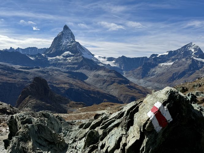
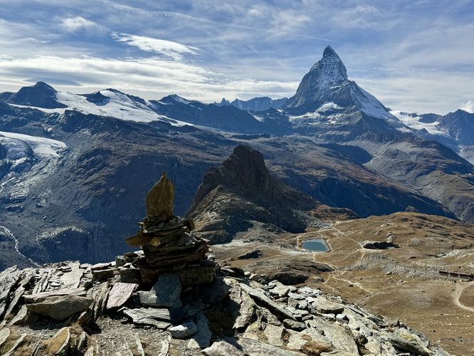
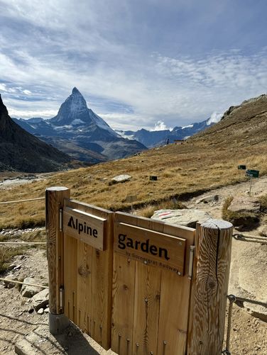
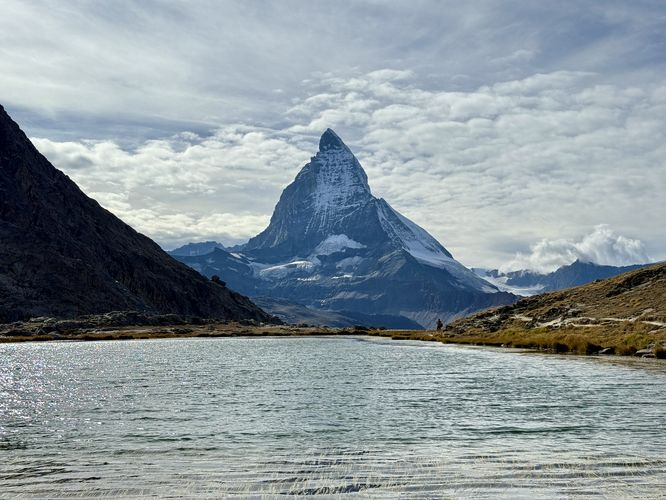
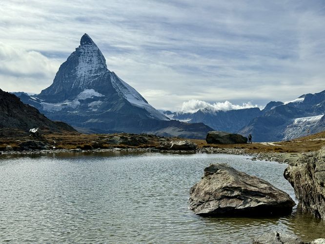
The hike down to Riffelsee is one of the most scenic around Zermatt as you'll find the Matterhorn in view the entire way down to Riffelsee, assuming weather conditions are perfect. Follow switchbacks with the scattered Swiss blazes of red stripes surrounded by white stripes, painted to bedrock. You may even see the Gornergrat Bahn carrying tourists up and down Gornergrat's steep slopes. Finally, around 2.6km (1.6 miles), you'll reach an Alpine Garden that encloses rare species of plants that only grow in the alpine. Just beyond the Alpine Garden sits a magical view of the Matterhorn with Riffelsee below your feet. Hike down the ridge further to reach the water's edge of Riffelsee where you'll find stunning views of the Matterhorn from this tranquil alpine lake.
Think you've seen enough at Riffelsee? Well near Riffelsee is the Rotenboden station where you can use a round-trip ticket or purchase a new one-way ticket to ride the Gornergrat Bahn back to Zermatt.
The hike from the second (unnamed) alpine lake leads up a short hill before the Gornergrat trail continues to descend through exposed alpine meadows and breathtaking Matterhorn views and glacier-capped Alps. The trail opens up with more north-facing Alps views, high above the Zermatt Valley. The Gornergrat trail leads further down the open meadows where a small church can be found on an off-shoot trail with Matterhorn views behind it — another great place to take a photo — located near 4.63km. Taking a right-hand turn here will lead hikers directly to Riffelberg station where you'll find a restaurant and Gornergrat station.
At Riffelberg station, hikers can choose to take the Gornergrat Bahn back to Zermatt or continue hiking down the mountain.
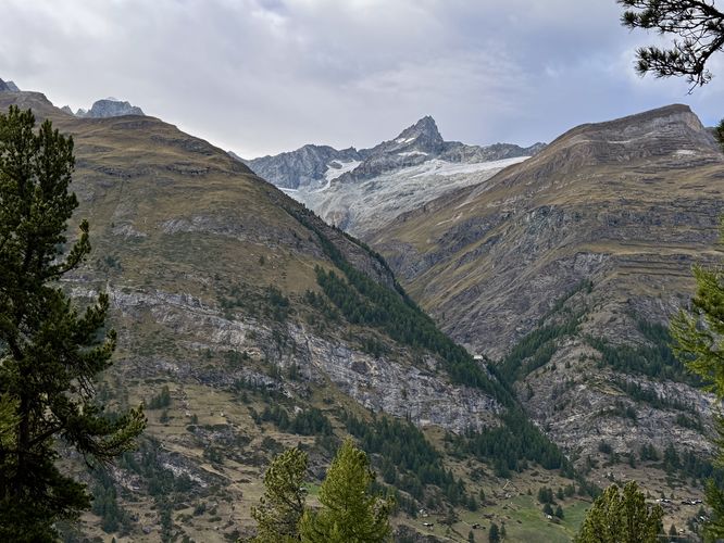
Once you leave Riffelberg, the trail leads downhill to reach a wide road. During our hike in September 2025, there was a large construction site right outside of Riffelberg, which we hiked around and has since re-routed the trail. Following the road, you'll find more exposed alpine meadows with Matterhorn views and Alps views above Zermatt. Near 6km, the hike leads further down trails that offer two options — either hike straight down or follow switchbacks. To keep the distance shorter, we hiked straight down and found more breathtaking views along the way. From here, you'll be following trails primarily used by mountain bikers, so keep an ear out for them.
Cross the road once more to follow the trail as it bends around the meadow and leads into undulating mountain biking terrain. And of course, there are more stunning views of the Matterhorn. Hike down the switchbacks of the mountain biking trail until it reaches the Riffelalp station at 7.9km. At Riffelalp station, you can grab a ride back to Zermatt while claiming all of the views of the Alps on your hike down from Gornergrat.
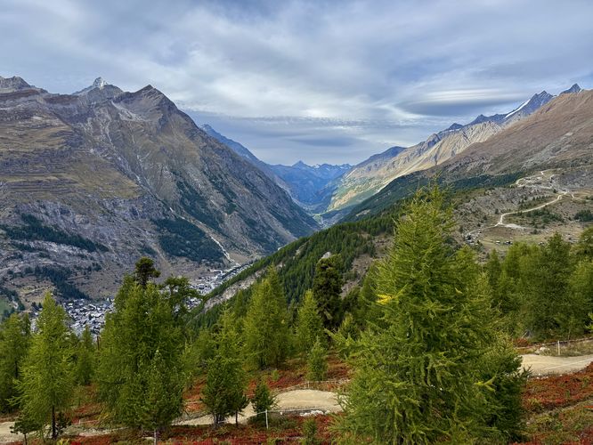
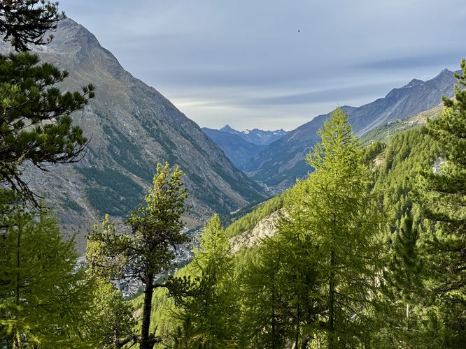
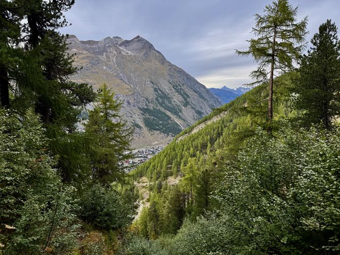
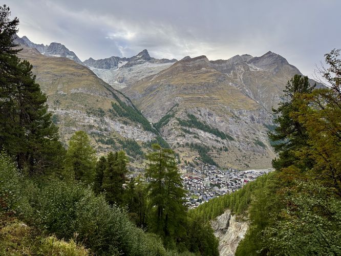
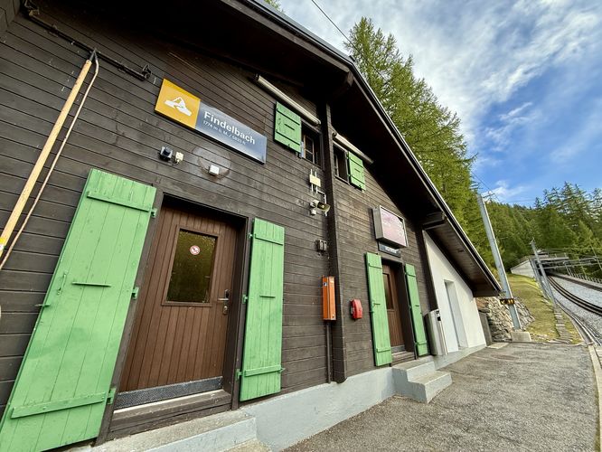
On the hike down, you'll find several viewpoints of the Zermatt Valley and its surrounding alpine peaks near 8.5km, 8.65km, 9km, and 9.6km. Most of the views are similar and maybe not as stunning as the Matterhorn views you hiked by earlier, but they're a nice change of scenery from the larch forest. Finally, the hike ends at Findelbach station at 10.5km with a one-way ride back to Zermatt station along the Gornergrat Bahn. Alternatively, you can even hike directly back to Zermatt for an additional ~1.6km from Findelbach.
This trail guide leads hikers up to the summit of Gornergrat via the Gornergrat Bahn (train) and then leads down the mountain to reach Findelbach station on a moderate 10.5km (6.5 mile) hike where you'll find mind-bending alpine views of the Monte Rosa massif, Gornergletscher (Gorner Glacier), Grenzgletscher, the Matterhorn, Zermatt, and the tranquil alpine lake, Riffelsee.
Hiking Gornergrat (Gorner Ridge)
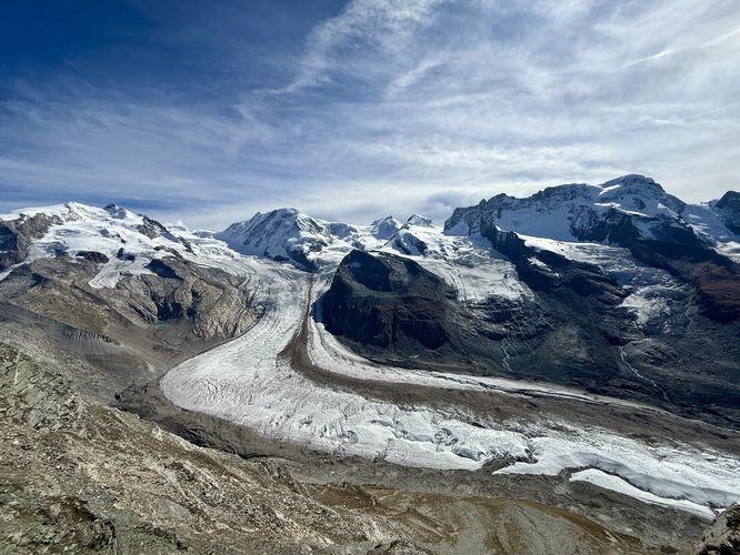
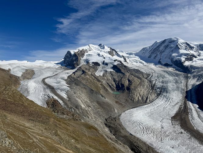
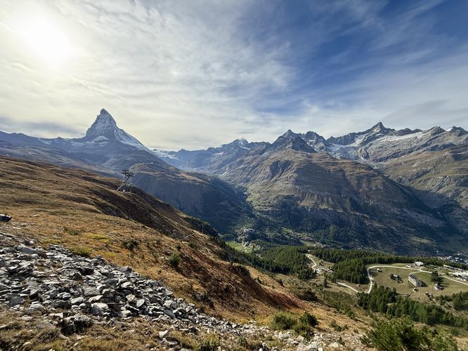
This hike begins at the Gornergrat station where the Gornergrat Bahn ends. Here, you'll find a universally-accessible pathway that leads from the train station to the summit of Gornergrat. Along the way up to the summit, visitors will find breathtaking views of the Monte Rosa massif, Grenzgletscher, Gornergletscher (Gorner Glacier), and distant views of the Matterhorn. At the very top of Gornergrat's summit sits a beautiful terrace with benches and 360-degree views high above Zermatt. Located to the north below your feet, you'll find Gornergratsee (Gorner Ridge Lake) and to the west sits the jagged peak of the Matterhorn. Standing on the very-top of Gornergrat's rocky summit, visitors will find similar views of the Monte Rosa massif and its glacier-covered alpine slopes with massive glaciers surrounding its flanks — the perfect place to take more 360-degree, panoramic photos.Gornergrat Summit to Riffeslsee - 0.4km to 2.9km
After you explore the universally-accessible path to Gornergrat summit, the real hike begins as you start your descent down Gorner Ridge toward Riffelsee, an alpine lake that sits below the jagged but small peak known as the Riffelhorn. On your hike down, you'll pass more views of glacier-covered alpine slopes to the south. These mountains separate Switzerland from Italy with Switzerland' side in view and Italy on the opposite side of the mountain ridge.The hike down to Riffelsee is one of the most scenic around Zermatt as you'll find the Matterhorn in view the entire way down to Riffelsee, assuming weather conditions are perfect. Follow switchbacks with the scattered Swiss blazes of red stripes surrounded by white stripes, painted to bedrock. You may even see the Gornergrat Bahn carrying tourists up and down Gornergrat's steep slopes. Finally, around 2.6km (1.6 miles), you'll reach an Alpine Garden that encloses rare species of plants that only grow in the alpine. Just beyond the Alpine Garden sits a magical view of the Matterhorn with Riffelsee below your feet. Hike down the ridge further to reach the water's edge of Riffelsee where you'll find stunning views of the Matterhorn from this tranquil alpine lake.
Think you've seen enough at Riffelsee? Well near Riffelsee is the Rotenboden station where you can use a round-trip ticket or purchase a new one-way ticket to ride the Gornergrat Bahn back to Zermatt.
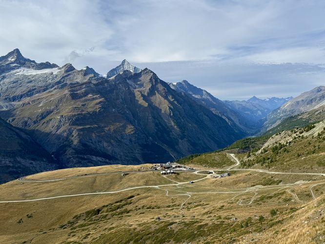
Riffelsee to Riffelberg Station - 2.9km to 4.75km
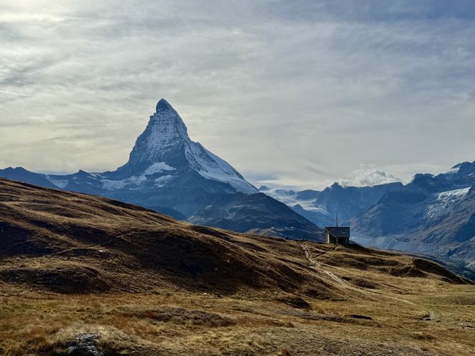
Once you leave Riffelsee, the tranquil alpine lake and Matterhorn views are not over. Hike west from Riffelsee to find another, smaller alpine lake with more background vistas of the Matterhorn — another great place to take pictures of these stunning Alps.The hike from the second (unnamed) alpine lake leads up a short hill before the Gornergrat trail continues to descend through exposed alpine meadows and breathtaking Matterhorn views and glacier-capped Alps. The trail opens up with more north-facing Alps views, high above the Zermatt Valley. The Gornergrat trail leads further down the open meadows where a small church can be found on an off-shoot trail with Matterhorn views behind it — another great place to take a photo — located near 4.63km. Taking a right-hand turn here will lead hikers directly to Riffelberg station where you'll find a restaurant and Gornergrat station.
At Riffelberg station, hikers can choose to take the Gornergrat Bahn back to Zermatt or continue hiking down the mountain.
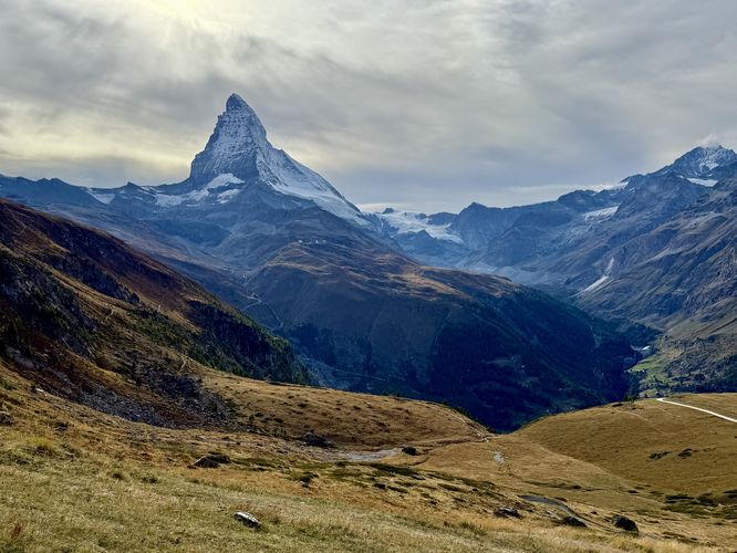
Riffelberg to Riffelalp Station - 4.75km to 7.9
Most hikers will end their hike at Riffelberg station, which was our original plan but due to the train timetable / schedule, we thought we could hike to Riffelalp and beat the train. We were wrong, but we found the hike from Riffelberg to Riffelalp is almost completely void of other hikers, but the hike provides more stunning Matterhorn views high above Zermatt.Once you leave Riffelberg, the trail leads downhill to reach a wide road. During our hike in September 2025, there was a large construction site right outside of Riffelberg, which we hiked around and has since re-routed the trail. Following the road, you'll find more exposed alpine meadows with Matterhorn views and Alps views above Zermatt. Near 6km, the hike leads further down trails that offer two options — either hike straight down or follow switchbacks. To keep the distance shorter, we hiked straight down and found more breathtaking views along the way. From here, you'll be following trails primarily used by mountain bikers, so keep an ear out for them.
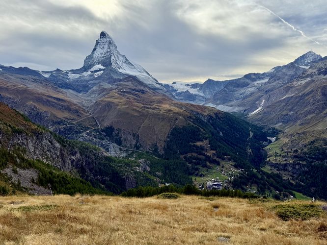
Cross the road once more to follow the trail as it bends around the meadow and leads into undulating mountain biking terrain. And of course, there are more stunning views of the Matterhorn. Hike down the switchbacks of the mountain biking trail until it reaches the Riffelalp station at 7.9km. At Riffelalp station, you can grab a ride back to Zermatt while claiming all of the views of the Alps on your hike down from Gornergrat.
Riffelalp to Findelbach Station - 7.9km to 10.5km
Missed the train at Riffelalp like we did? On our hike, we miscalculated and missed the train. The next train was 1 hour away, so we decided to hike down to Findelbach station from Riffelalp. The hike to Findelbach station begins in the forest and follows many switchbacks down through the forest of larch trees. We've never seen so many larch in the Alps outside of this route.On the hike down, you'll find several viewpoints of the Zermatt Valley and its surrounding alpine peaks near 8.5km, 8.65km, 9km, and 9.6km. Most of the views are similar and maybe not as stunning as the Matterhorn views you hiked by earlier, but they're a nice change of scenery from the larch forest. Finally, the hike ends at Findelbach station at 10.5km with a one-way ride back to Zermatt station along the Gornergrat Bahn. Alternatively, you can even hike directly back to Zermatt for an additional ~1.6km from Findelbach.