Loading...

๐ŸŽ‰ Enjoy a Free 7-Day Supporter Trial and Unlock Exclusive Perks โ€” No Credit Card Required. Learn more.

Little Table Rock Mountain Hike

Directions
Map
Pictures
Send to App
Distance:
4.1 Miles / 6.6 km
Type:
Out-and-Back
Difficulty:
Moderate
Time to Hike:
2 hours, ~5 minutes
Features:
Surface Type:
Dirt
Town:
Spruce Pine, North Carolina
Directions:
35.8999, -81.983932
Added:
April 01, 2025
Updated:
April 06, 2025
Copy Trail Link Hiking this trail? Send a friend or family member a link to this trail guide for your own safety. Hike at your own risk (disclaimer)
Loading...
Loading...
1,017'

Total Change
1,245'

Ascent
1,237'

Descent

Download the Trail Route for Offline Use

Supporters get exclusive access to download trail routes to the MyHikes app for offline use. Stay prepared on your adventure, even without an internet connection! Become a Supporter today to unlock this feature and hike with confidence.

Send to App

Little Table Rock Mountain Hike

The summit of Little Table Rock Mountain lies on the Eastern Continental Divide and marks the Avery, McDowell, and Mitchell tri-county border. Established in 2013, Stanback Trails preserved small pockets of land adjacent to the Blue Ridge Parkway with the help of conservationists Fred and Alice Stanback. The Little Table Rock Mountain Trail in the 544-acre Little Table Rock Tract is the longest and most difficult of the three Stanback Trails. From the parking area youโ€™ll climb over 1,000 feet in 2.1 miles through open hardwood forests. Youโ€™re unlikely to see anyone on this hike, so make sure you bring trail directions. From the small, conical summit there is a nice view north of the Unaka Mountains rising above the North Toe River valley. Although unspectacular compared to other hikes in the area, youโ€™ll appreciate the work the Stanbacks have done to help conserve mountain treasures all over North Carolina.

Hunting Considerations โ€“ This hike passes through Pisgah Game Land. During hunting seasons you should wear bright orange or similar bright colors while hiking. For hunting season information and schedules please visit the North Carolina Wildlife Resources Commission for yearly updates.
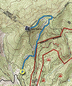
  • Mile 0.0 โ€“ The Little Table Rock Mountain Trailhead has a nice gravel parking area and large information kiosk with a trail map. The trail initially follows a wide forest road north.

  • Mile 0.8 โ€“ At a T-junction the Little Table Rock Mountain Trail turns left leaving the forest road. A large plaque on the ground gives an overview of the tract. From here the trail is blue-blazed and follows a single-track path.

  • Mile 1.1 โ€“ Stay left at a Y-junction with an old forest road.

  • Mile 1.15 โ€“ Stay right crossing a small stream.

  • Mile 1.3 โ€“ The trail begins switchbacking through a wide bowl. It is easy to lose the trail here since it isnโ€™t well-defined, continue to the ridgeline if you cannot follow the blazes.

  • Mile 1.5 โ€“ T-junction with a forest road along the ridgeline. Turn left following the forest road west.

  • Mile 2.1 โ€“ Reach the wooded summit of Little Table Rock Mountain (4,080 feet). A path on the right leads to a small outcrop with a view north. The North Toe River valley is encircled by the Unaka Mountains and Blue Ridge Escarpment. You also have a direct sightline of the tiny Avery County Airport near Spruce Pine. Imagine the view small planes have landing here beneath these high mountains. This area is well-known for its quartz and kaolin mines, which youโ€™ll easily spot as large open scars on the slopes outside of town. The southern Unaka Mountains including the Roan Highlands rise high above the region. Turn around and hike back towards the trailhead.

  • Mile 4.1 โ€“ Hike ends at the Little Table Rock Mountain Trailhead.
By HikingUpward Contributor: Zach Robbins
Explore 43 trails near Spruce Pine, NC
  1. Parking

    35.8999, -81.983932
  2. Main Trailhead

    35.90002, -81.984015
No community routes found. To add your own hike as a Community Route for this Trail guide, leave a Trip Report with an attached GPX file.

Hazards

Snakes
Poison Ivy/Oak

Seasons

All

Blaze Color

Blue

Weather Forecast

In Spruce Pine, NC

Explore Hiking Trails

You May Also Like

Colorado's Million Dollar Highway - Plan a day's drive adventure along the iconic Million Dollar Highway in Colorado. Explore the best short trails, roadside stops, waterfalls, vistas, ghost towns, and hot springs within a ~6 hour road trip.
Explore

Colorado's Million Dollar Highway

Plan a day's drive adventure along the iconic Million Dollar Highway in Colorado. Explore the best short trails, roadside stops, waterfalls, vistas, ghost towns, and hot springs within a ~6 hour road trip.

Read
Glacier's Going-to-the-Sun Road - Discover the breathtaking beauty of Glacier National Park along the iconic Going-to-the-Sun Road. From stunning roadside stops to picturesque waterfalls and vistas, this engineering marvel offers endless opportunities for exploration.
Explore

Glacier's Going-to-the-Sun Road

Discover the breathtaking beauty of Glacier National Park along the iconic Going-to-the-Sun Road. From stunning roadside stops to picturesque waterfalls and vistas, this engineering marvel offers endless opportunities for exploration.

Read
New York's Best Waterfalls - Whether you're planning a day hike, roadside stop, or a leisurely short walk, this guide provides hikers, travelers, and locals alike with 63 different locations to over 100 scenic waterfalls to help plan your next adventure!
Explore

New York's Best Waterfalls

Whether you're planning a day hike, roadside stop, or a leisurely short walk, this guide provides hikers, travelers, and locals alike with 63 different locations to over 100 scenic waterfalls to help plan your next adventure!

Read
25 Best Day Hikes in North Carolina - Discover the top 25 best day hikes in North Carolina, from breathtaking waterfalls to mountain peaks. Explore hidden gems, scenic views, and trails suitable for all skill levels, perfect for your next outdoor adventure.
Explore

25 Best Day Hikes in North Carolina

Discover the top 25 best day hikes in North Carolina, from breathtaking waterfalls to mountain peaks. Explore hidden gems, scenic views, and trails suitable for all skill levels, perfect for your next outdoor adventure.

Read

Before you boogie...

Find our trail guides useful? Consider becoming a Supporter to unlock perks!

MyHikes is an indie platform that makes exploring public trails easier for everyone. The platform has no investors, no ads, and is owned and operated by one person, Dave Miller. Dave has personally mapped and written over 1,800 trail guides on MyHikes for the public to explore. MyHikes has helped millions outdoor enthusiasts plan their next adventure.

But it takes a lot of time ๐Ÿ•ฆ, money ๐Ÿ’ฐ, work, and espresso shots โ˜• to run MyHikes, including hiking , mapping , writing , and publishing new trails with high-quality (accurate) information... along with software engineering (coding) the platform like building new features, website and mobile app development (iOS and Android), site maintainance . and much much more.

Supporters unlock website and mobile app perks with an annual one-time payment of $25 (you renew) ๐Ÿ˜Ž๐Ÿ‘. Or you can simply make a Donation of your choice. Otherwise, you can support us by telling your friends about MyHikes - both quick and free ๐ŸŽ‰

Admin user profile picture

Dave Miller
MyHikes Founder