Take a journey on the Mountains-to-Sea Trail as it climbs from the middling Elk Mountains to the heights of the Great Craggy Mountains that dominate the Swannanoa Valley. This is a popular area of hiking due its proximity to Asheville and ease of access. You’ll see a lot of trail runners and hikers around Rattlesnake Lodge, an historic summer home built in 1903 and destroyed by fire in 1920. In fact, much of the Mountains-to-Sea Trail from Bull Gap to Lane Pinnacle is part of an old carriage road system that was intended to be a scenic mountain highway, the precursor to the Blue Ridge Parkway. Once you hike past the lodge remnants the crowds disappear as you climb in earnest to the crest of the Bull Mountain massif. The ridgeline heading towards the lofty Lane Pinnacle hovers around 4,800 feet, but it’ll feel much higher. Lane Pinnacle at 5,230 feet is one of the big peaks of the Great Craggies and readily identifiable from I-40. The tiny summit offers outstanding views of the Beetree Reservoir with the Swannanoa Mountains and Hickory Nut Mountains rising behind. During warmer weather this section should be considered for a shuttle hike utilizing multiple parking areas in Craggy Gardens east of Lane Pinnacle.
Alternative parking – There are two parking areas along Ox Creek Road that afford the option of shorter versions of this hike. The first lot at mile 0.4 is small and can only fit 2-3 cars. This would be a 10.3-mile hike. The second lot is at mile 0.8 and has ample space for 10 cars. The hike would be 9.5 miles starting here.
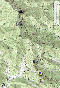
- Mile 0.0 – Elk Mountain Scenic Highway makes a big S-curve after it meets Ox Creek Road ending at the Blue Ridge Parkway. You can park along the side of the road or a large gravel area beside the parkway. The Mountains-to-Sea Trail [440] (white blaze) crosses the road at this S-curve. Locate the trail crossing and turn right to head east.
- Mile 0.4 – Pass a small parking area on Ox Creek Road.
Alternative parking #1 for a 10.3-mile hike. This parking area can only fit 2-3 cars and it is illegal to park along Ox Creek Road in non-designated parking areas.
- Mile 0.8 – MST passes through Bull Gap. There is a large parking area on Ox Creek Road on the left and a connection to the Blue Ridge Parkway on the right. From here the trail climbs via a series of switchbacks.
Alternative parking #2 for a 9.5-mile hike. This parking area can easily fit 10+ cars.
- Mile 1.4 – Small view east of High Swain.
- Mile 2.0 –Foundation of the barn to the right below the trail, the first of the remnants of Rattlesnake Lodge.
- Mile 2.1 –Main area of Rattlesnake Lodge remnants. The large flat area on the right was the yard with the swimming pool below on the right between two retaining walls. A trail on the left side of the yard leads to an area called The "Den." The tennis court was on the left side of the main trail behind the information board. When you continue past the yard area there is a junction with a blue-blazed trail following steps south for 0.4-mi to parking beside the Tanbark Ridge Tunnel on the Blue Ridge Parkway. After you swing around the creek drainage the blue trail continues on the left. This trail leads to the reservoir in 0.2-mi and to the MST in 0.3-mi. The foundations around the creek drainage below the trail were part of the tool shed which contained a generator while the spring house and caretaker's cabins were on the left side of the trail. The spring house remnants are located under the huge fallen tree and supplied water to the lodge.
- Mile 2.4 –An old chimney, the only remains from The Shack, marks the end of the Rattlesnake Lodge area. On the right another blue-blazed trail leads down to the Tanbark Ridge Tunnel parking area. The MST begins climbing the west side of High Swain through a beautiful forest.
- Mile 2.9 –T-junction with the blue-blazed trail beside a spring. The trail leaves the shrub tunnels and climbs through open hardwood forest below Rocky Knob.
- Mile 3.8 – The MST, lined with green moss, briefly levels out at a saddle between Rocky Knob and Rich Knob. The climb to the shoulder of Rich Knob is the steepest of the day.
- Mile 4.2 – Shoulder of Rich Knob. The MST now follows a high ridge above 4,800 feet east towards Lane Pinnacle and the Great Craggy Mountains. The airy, narrow ridge is a noticeable change in scenery from the smaller Elk Mountains.
- Mile 4.5 – MST crosses the summit of Bull Mountain.
- Mile 4.8 – From the summit of Wolfden Knob you’ll be able to see the conical summit of Lane Pinnacle through the trees. The trail drops into a gap and then climbs steeply to Lane Pinnacle.
-
Mile 5.6 – Reach the tiny summit of Lane Pinnacle. On the right side of the trail is a rock outcrop with a beautiful view south of the mountains surrounding the Beetree Reservoir. On your left a ridge extending from Craggy Knob obscures the view of the larger Burnett Reservoir. The Swannanoa Mountains rise behind the Beetree Reservoir on the south side of I-40 with the tallest peaks of the Hickory Nut Mountains
dotting the horizon. The tower atop Little Pisgah Mountain should be
easy to locate, dead center view. From left to right the tallest peaks
are Shumont Mountain, Sugarloaf Mountain, Little Pisgah Mountain, and Bearwallow Mountain.
Optional Viewpoint: Although we did not include this, a fantastic viewpoint nicknamed the Raven's Call overlook is an additional 0.3-mi northeast on the MST from Lane Pinnacle. This rock outcrop has outstanding views, much better than Lane Pinnacle, and is highly recommended if you have time. A shuttle hike with a second car at Beetree Gap is a great option for hiking this section.
- Mile 10.2 – Hike ends at Elk Mountain Scenic Highway.