Loading...

❄️ WINTER SALE! 50% OFF on Supporter Accounts — now through January 31st. Unlock a full year of exclusive website & app perks. Learn More.

Lai da Ova Spin Reservoir Overlook

Directions
Map
Pictures
Download Lai da Ova Spin Reservoir Overlook GPX Data to the MyHikes Mobile App
Distance:
0 km / 0 Miles
Type:
Out-and-Back
Difficulty:
Easy
Time to Hike:
~5 minutes
Features:
Surface Type:
Universal Access
Town:
Zernez, Switzerland
Get Directions:
46.679413, 10.16406
Added:
September 22, 2025
Updated:
December 14, 2025
Copy Trail Link Hiking this trail? Send a friend or family member a link to this trail guide for your own safety. Hike at your own risk (disclaimer)
Loading...

Download the GPX Data for Offline Use

Supporters get exclusive access to download trail routes to the MyHikes app for offline use. Stay prepared on your adventure, even without an internet connection! Become a Supporter today to unlock this feature and hike with confidence.

Download Lai da Ova Spin Reservoir Overlook GPX Data to the MyHikes Mobile App

Key Takeaways

  • The Lai da Ova Spin overlook is a universally accessible roadside stop on Route 28 (Via Pass dal Fuorn), allowing visitors to enjoy spectacular Swiss Alps scenery and the reservoir's beauty with minimal walking.
  • This stop is famous for its striking, opaque turquoise water, created by glacial flour, offering a stunning, high-contrast photo opportunity on the edge of the Swiss National Park.
  • Located just minutes east of Zernez, the reservoir serves as an easy, essential, and quick pull-off for any road tripper traveling the scenic Ofen Pass road.

Lai da Ova Spin Reservoir Overlook

If you are driving through the Engadine Valley or crossing the Ofen Pass (Pass dal Fuorn), there is a beautiful view of turquoise water demands attention. The Lai da Ova Spin is more than just a hydroelectric reservoir; it is a breathtaking mirror of the Swiss Alps located right on the edge of the Swiss National Park.

This guide covers everything you need to know about this accessible, low-effort, high-reward roadside stop near Zernez, Switzerland.

Scenic Overlook: Turquoise Waters and Alpine Peaks

This stop offers one of the best "effort-to-view" ratios in Switzerland for road trippers. As soon as you pull over, you are greeted by the vivid colors of the Spöl River in the valley below, held back by its hydroelectric dam.

The water of the Lai da Ova Spin is famous for its milky, opaque turquoise hue — a result of glacial flour (fine rock silt) suspended in the water. Surrounded by the dark green larches and evergreen trees of the Swiss National Park, the color contrast is surreal.

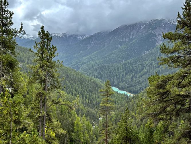
Looking upward, you are surrounded by the towering peaks of the Swiss Alps. Because the reservoir sits in a deep gorge, the mountains feel incredibly close and vertical, creating a dramatic backdrop for photos.

Universal Accessibility: A View for Everyone

Since this roadside stop is not a hike but rather a short walk, visitors will find that the viewpoint is universally accessible. Visitors can drive up to the view, where you can enjoy the stunning alpine scenery right from your vehicle. Or you can step outside of your car, along the flat crushed gravel turnout, to reach the viewpoint with little to no effort required.

Parking

Visitors will find a parking turnout at the coordinates provided (46.679413, 10.16406), located on the south side of Route 28 (Ova Spin / Via Pass dal Fuorn). The parking turnout is large enough to fit about 5 vehicles and is generally empty.
Explore 7 trails near Zernez, Switzerland
  1. Parking

    46.679413, 10.16406
  2. Main Trailhead

    46.679413, 10.16406
  3. View of the turquoise Lai da Ova Spin reservoir in Swiss National Park

    46.679333, 10.163994
    View of the turquoise Lai da Ova Spin reservoir in Swiss National Park
No community routes found. To add your own hike as a Community Route for this Trail guide, leave a Trip Report with an attached GPX file.

Hazards

Rockfalls / Ledges / or Scrambles

Seasons

All

Photo Albums

+ Add Photo Album

Upload your photos from the trail to help others know what to expect.

Preview of the MyHikes mobile app interface

Track, Log, and Explore Hikes with the MyHikes App

Shop Landscape Prints
Shop our Alps landscape prints to support MyHikes!

Trip Reports (Reviews)

Ready to help fellow hikers? Add a trip report to share your experience and provide valuable insights for those planning their next hike. Your review makes the trail better for everyone.

Rated 4.0 out of 5 based on 1 rating.
0 miles / 0 km
September 27, 2025
Nice roadside stop on a road trip through the Swiss Alps. Beautiful turquoise waters of the reservoir from high above.
Hiking

Explore Hiking Trails

You May Also Like

Before you boogie...

Find our trail guides useful? Consider becoming a Supporter to unlock perks!

MyHikes is an indie platform that makes exploring public trails easier for everyone. The platform has no investors, no ads, and is owned and operated by one person, Dave Miller. Dave has personally mapped and written over 1,900 trail guides on MyHikes for the public to explore. MyHikes has helped millions outdoor enthusiasts plan their next adventure.

But it takes a lot of time 🕦, money 💰, work, and espresso shots ☕ to run MyHikes, including hiking , mapping , writing , and publishing new trails with high-quality (accurate) information... along with software engineering (coding) the platform like building new features, website and mobile app development (iOS and Android), site maintainance . and much much more.

Supporters unlock website and mobile app perks with an annual one-time payment of $25 (you renew) 😎👍. Or you can simply make a Donation of your choice. Otherwise, you can support us by telling your friends about MyHikes - both quick and free 🎉

Admin avatar

Dave Miller
MyHikes Founder
🍪 We use cookies to learn about site usage, performance, and to serve map tiles. You may block cookies manually in the browser. By continuing to use MyHikes, you agree. Learn more