Loading...

🌲 WINTER SALE! 50% OFF on Supporter Accounts — now through December 31st. Unlock a full year of exclusive website & app perks for better hikes. Learn More.

Lago di Misurina (Lake Misurina) Trail

Directions
Map
Pictures
Download Lago di Misurina (Lake Misurina) Trail GPX Data to the MyHikes Mobile App
Distance:
2.6 km / 1.6 Miles
Type:
Loop
Difficulty:
Easy
Time to Hike:
~48 minutes
Features:
Surface Type:
Universal Access
Town:
Misurina, Italy
Get Directions:
46.582157, 12.25224
Added:
September 25, 2025
Updated:
November 23, 2025
Copy Trail Link Hiking this trail? Send a friend or family member a link to this trail guide for your own safety. Hike at your own risk (disclaimer)
Loading...
Loading...
12m

Total Change
18m

Ascent
23m

Descent

Download the GPX Data for Offline Use

Supporters get exclusive access to download trail routes to the MyHikes app for offline use. Stay prepared on your adventure, even without an internet connection! Become a Supporter today to unlock this feature and hike with confidence.

Download Lago di Misurina (Lake Misurina) Trail GPX Data to the MyHikes Mobile App

Key Takeaways

  • This flat, 2.65 km (1.65 mile) trail around Lago di Misurina is perfect for all skill levels, offering iconic views of Tre Cime di Lavaredo (weather permitting) and the historic Istituto Pio XII asthma center against an alpine backdrop.
  • Ideal for families and casual walkers, the route features a mix of dirt paths and paved roads that are universally accessible for most of the loop, allowing easy navigation along the water's edge and past the Grand Hotel Misurina.
  • Located directly off SP49, the trail offers public parking on the west shore and welcomes leashed dogs, making it a hassle-free stop for travelers exploring the Italian Alps.

Lago di Misurina (Lake Misurina) Trail

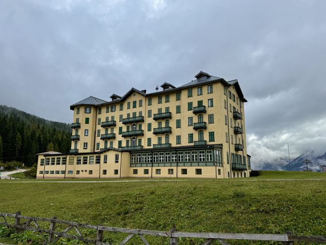
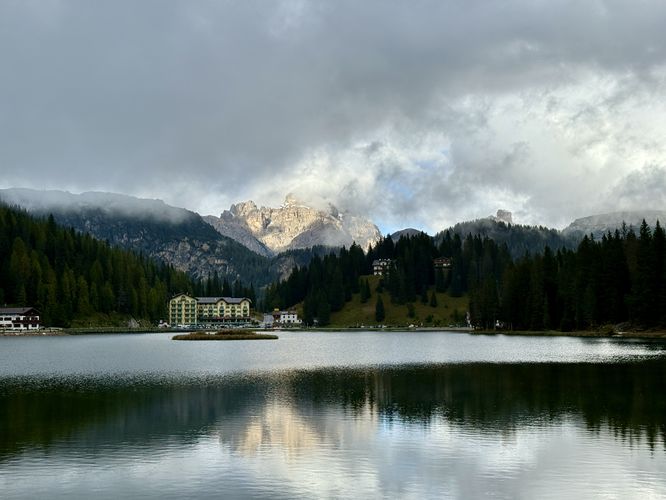
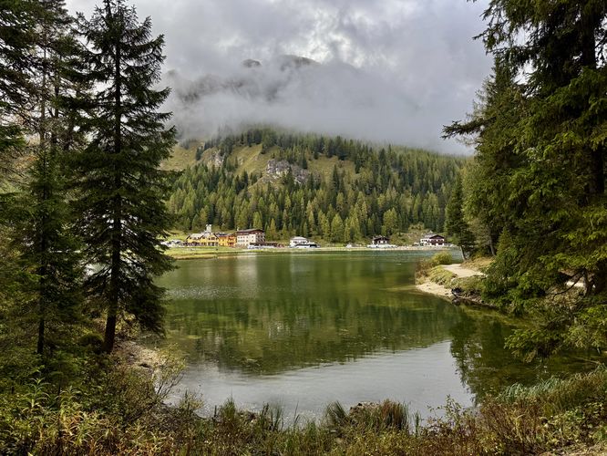
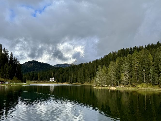
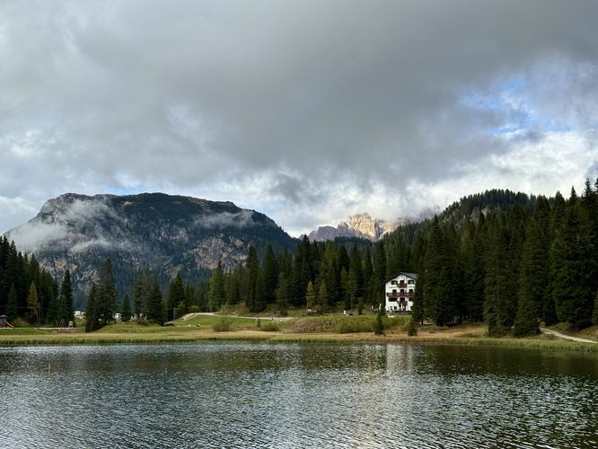
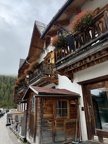
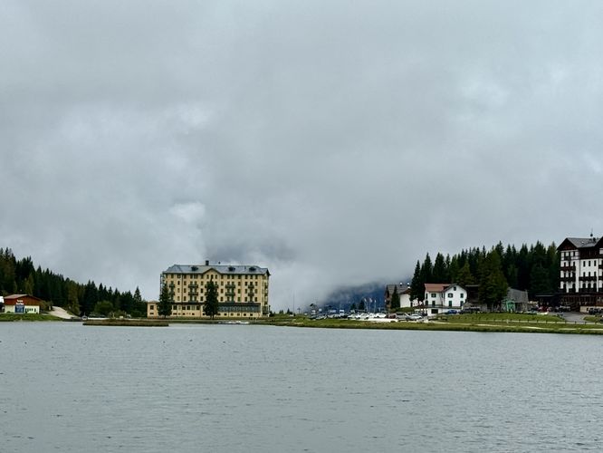
Discover the magic of the Italian Alps with an easy stroll around Lago di Misurina, often referred to as the "Pearl of the Dolomites". This accessible 2.65 km (1.65 miles) loop trail takes you on a scenic counterclockwise journey along the water’s edge, offering mirror-like reflections of towering alpine peaks at every turn. As you wander the flat, gravel path, you will pass iconic landmarks like the historic Istituto Pio XII di Misurina—renowned for its healing mountain air—and admire the alpine architecture of the Grand Hotel Misurina and Hotel Miralago. From the rustic charm of Quinz Locanda al Lago to views of the quaint village center, this hike offers an unforgettable mix of natural beauty and alpine culture.

Walking the Pearl of the Dolomites: The Lago di Misurina Loop Trail

The Lake Misurina Trail starts pretty much anywhere publicly accessible along the edge of the water, but this route begins in the center of town on the west shore near Sport Hotel at the public parking lot. The trail leads in both north/south directions, but this route first heads south toward the historic asthma treatment center, Istituto Pio XII di Misurina.

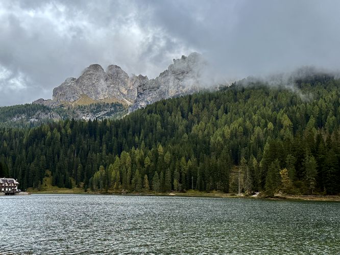
At the trailhead, visitors will first find north-facing views of the alpine peaks that comprise this sought-after area of the Dolomites, including Tre Cime di Lavaredo on clear days. Tre Cime di Lavaredo was our main focus for coming to Misurina, but due to the clouds, snow, and ice, we changed gears to instead explore the nearby lakes and we're glad we did! The hike around Lago di Misurina is an easy, beautiful way to enjoy the Italian Alps.

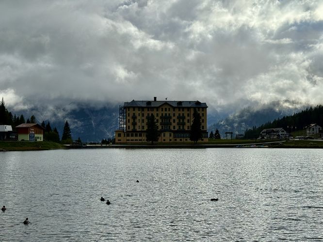
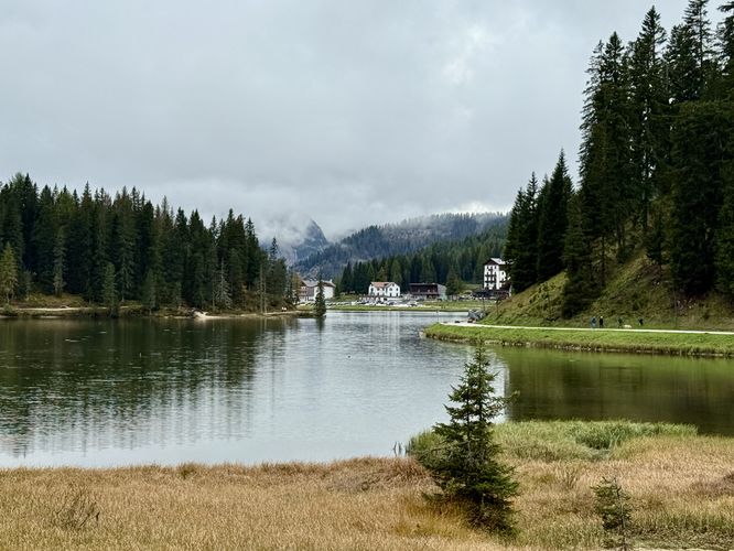
The trail leads south to reach the historic Istituto Pio XII before it curves north along the eastern side of Lake Misurina, passing through the forest along the lake's edge. On the eastern side of the trail, hikers will find more views of Lago di Misurina, the historic asthma institute, the neighboring village buildings to the west, and the towering alpine peaks of the Dolomites to the north and south, especially on clear days.

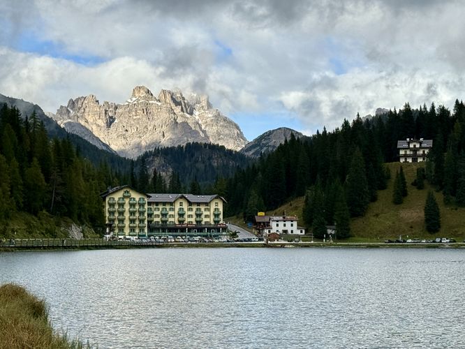
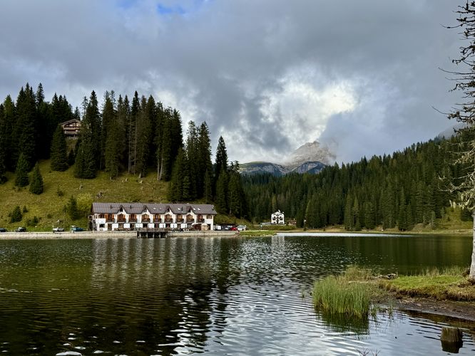
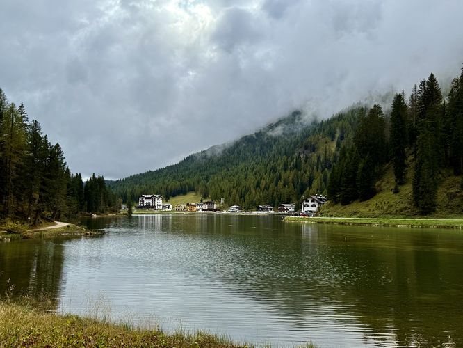
The Lake Misurina Trail continues northbound before reaching viewpoints of the water with Hotel Miralago and Quinz Locanda al Lago. Following the trail further, it starts to wrap around the northern end of Lake Misurina before it heads back south along the road. Despite a bit of road walking, the north side of the trail features beautiful views of the alpine mountains behind the historic Istituto Pio XII di Misurina (on clear days). The trail finally wraps up at the trailhead and parking lot for a short and easy 2.6 km (1.6 mile) loop hike around Lago di Misurina.

Universal Access

Visitors should note that the Lake Misurina Trail is universally accessible in almost all of the trail's length. It starts out along a dirt path before switching to pavement near the historic asthma treatment center. On the north shore, the trail leads back to a paved road and leads back to parking.  

Parking & Directions: Getting to Lake Misurina

Visitors to Lake Misurina will find the lake situated on the east side of SP49. The parking coordinates provided (46.582157, 12.25224) will lead you to the west side of the lake where public parking can be found in a small parking lot. The parking lot can fit about 10 vehicles as of September 2025, however, the Lake Misurina has other public parking spaces available. Simply drive around the lake to find a public parking space in case this lot is full.

Pets

Dogs are allowed on the Lake Misurina Trail only if leashed and must be cleaned up after.

Explore More Stunning Lakes in the Dolomites

No trip to the Italian Alps is complete without touring the region's most spectacular turquoise-hued lakes! While each location offers a unique view of the limestone peaks, they are often just a short drive apart. Enhance your Dolomites adventure itinerary by exploring our complete guides to the best nearby alpine lakes: the world-famous Lago di Braies, the scenic Lago di Dobbiaco, the roadside gem Lago di Landro, and the serene Lago d'Antorno.
Explore 8 trails near Misurina, Italy
  1. Parking

    46.582157, 12.25224
  2. Main Trailhead

    46.582157, 12.25224
  3. View of alpine mountains and Lake Misurina

    46.582108, 12.252231
    View of alpine mountains and Lake Misurina
  4. View of Grand Hotel Misurina and towering alpine peaks of the Dolomites

    46.580069, 12.252589
    View of Grand Hotel Misurina and towering alpine peaks of the Dolomites
  5. Istituto Pio XII di Misurina (former asthma treatment center for children)

    46.578653, 12.252203
    Istituto Pio XII di Misurina (former asthma treatment center for children)
  6. North-facing view of Lago di Misurina, Grand Hotel Misurina, and alpine peaks

    46.578297, 12.253206
    North-facing view of Lago di Misurina, Grand Hotel Misurina, and alpine peaks
  7. Forest view of Lake Misurina from the trail

    46.579739, 12.255261
    Forest view of Lake Misurina from the trail
  8. View of Istituto Pio XII di Misurina

    46.580647, 12.254689
    View of Istituto Pio XII di Misurina
  9. Northern view of Lake Misurina and a nearby restaurant

    46.582206, 12.255267
    Northern view of Lake Misurina and a nearby restaurant
  10. View of Hotel Miralago along Lake Misurina

    46.582189, 12.256153
    View of Hotel Miralago along Lake Misurina
  11. Alpine peaks sit in the clouds with a view of Lago di Misurina and Hotel Miralago

    46.583953, 12.258311
    Alpine peaks sit in the clouds with a view of Lago di Misurina and Hotel Miralago
  12. A view of Lago di Misurina from the northeast shore

    46.584583, 12.259022
    A view of Lago di Misurina from the northeast shore
  13. South-facing view of Lago di Misurina from the north shore

    46.585719, 12.258786
    South-facing view of Lago di Misurina from the north shore
  14. Quinz Locanda al Lago

    46.583831, 12.256206
    Quinz Locanda al Lago
  15. Cloudy view of Lake Misurina

    46.583939, 12.254144
    Cloudy view of Lake Misurina
No community routes found. To add your own hike as a Community Route for this Trail guide, leave a Trip Report with an attached GPX file.

Seasons

All

Photo Albums

+ Add Photo Album

Upload your photos from the trail to help others know what to expect.

Preview of the MyHikes mobile app interface

Track, Log, and Explore Hikes with the MyHikes App

Shop Landscape Prints
Shop our Alps landscape prints to support MyHikes!

Trip Reports (Reviews)

Ready to help fellow hikers? Add a trip report to share your experience and provide valuable insights for those planning their next hike. Your review makes the trail better for everyone.

Your opinion matters! Be the first to rate this trail.

Explore Hiking Trails

You May Also Like

Colorado's Million Dollar Highway - Plan a day's drive adventure along the iconic Million Dollar Highway in Colorado. Explore the best short trails, roadside stops, waterfalls, vistas, ghost towns, and hot springs within a ~6 hour road trip.
Explore

Colorado's Million Dollar Highway

Plan a day's drive adventure along the iconic Million Dollar Highway in Colorado. Explore the best short trails, roadside stops, waterfalls, vistas, ghost towns, and hot springs within a ~6 hour road trip.

Read
Glacier's Going-to-the-Sun Road - Discover the breathtaking beauty of Glacier National Park along the iconic Going-to-the-Sun Road. From stunning roadside stops to picturesque waterfalls and vistas, this engineering marvel offers endless opportunities for exploration.
Explore

Glacier's Going-to-the-Sun Road

Discover the breathtaking beauty of Glacier National Park along the iconic Going-to-the-Sun Road. From stunning roadside stops to picturesque waterfalls and vistas, this engineering marvel offers endless opportunities for exploration.

Read
New York's Best Waterfalls - Whether you're planning a day hike, roadside stop, or a leisurely short walk, this guide provides hikers, travelers, and locals alike with 63 different locations to over 100 scenic waterfalls to help plan your next adventure!
Explore

New York's Best Waterfalls

Whether you're planning a day hike, roadside stop, or a leisurely short walk, this guide provides hikers, travelers, and locals alike with 63 different locations to over 100 scenic waterfalls to help plan your next adventure!

Read

Before you boogie...

Find our trail guides useful? Consider becoming a Supporter to unlock perks!

MyHikes is an indie platform that makes exploring public trails easier for everyone. The platform has no investors, no ads, and is owned and operated by one person, Dave Miller. Dave has personally mapped and written over 1,800 trail guides on MyHikes for the public to explore. MyHikes has helped millions outdoor enthusiasts plan their next adventure.

But it takes a lot of time 🕦, money 💰, work, and espresso shots ☕ to run MyHikes, including hiking , mapping , writing , and publishing new trails with high-quality (accurate) information... along with software engineering (coding) the platform like building new features, website and mobile app development (iOS and Android), site maintainance . and much much more.

Supporters unlock website and mobile app perks with an annual one-time payment of $25 (you renew) 😎👍. Or you can simply make a Donation of your choice. Otherwise, you can support us by telling your friends about MyHikes - both quick and free 🎉

Admin avatar

Dave Miller
MyHikes Founder
🍪 We use cookies to learn about site usage, performance, and to serve map tiles. You may block cookies manually in the browser. By continuing to use MyHikes, you agree. Learn more