Loading...

🌲 WINTER SALE! 50% OFF on Supporter Accounts — now through December 31st. Unlock a full year of exclusive website & app perks for better hikes. Learn More.

Lago d'Antorno (Lake Antorno) Trail

Directions
Map
Pictures
Download Lago d'Antorno (Lake Antorno) Trail GPX Data to the MyHikes Mobile App
Distance:
0.6 km / 0.4 Miles
Type:
Loop
Difficulty:
Easy
Time to Hike:
~12 minutes
Features:
Surface Type:
Dirt
Town:
Misurina, Italy
Get Directions:
46.594658, 12.264238
Added:
September 25, 2025
Updated:
November 23, 2025
Copy Trail Link Hiking this trail? Send a friend or family member a link to this trail guide for your own safety. Hike at your own risk (disclaimer)
Loading...
Loading...
4m

Total Change
7m

Ascent
7m

Descent

Download the GPX Data for Offline Use

Supporters get exclusive access to download trail routes to the MyHikes app for offline use. Stay prepared on your adventure, even without an internet connection! Become a Supporter today to unlock this feature and hike with confidence.

Download Lago d'Antorno (Lake Antorno) Trail GPX Data to the MyHikes Mobile App

Key Takeaways

  • The Lago d'Antorno Trail is a beginner-friendly 0.72 km (0.45 mile) flat loop, perfect for families and travelers seeking high-reward mountain scenery with minimal effort.
  • Capture stunning reflections of the towering limestone peaks, especially from the west side trail and footbridge, during sunset or sunrise (Golden Hour) when the light illuminates the Italian Alps.
  • Located just minutes from the famous Lago di Misurina, Lake Antorno offers quieter, easy-access Dolomites views and features unique mushroom-shaped tree stump carvings on the east shore.

Lago d'Antorno (Lake Antorno) Trail

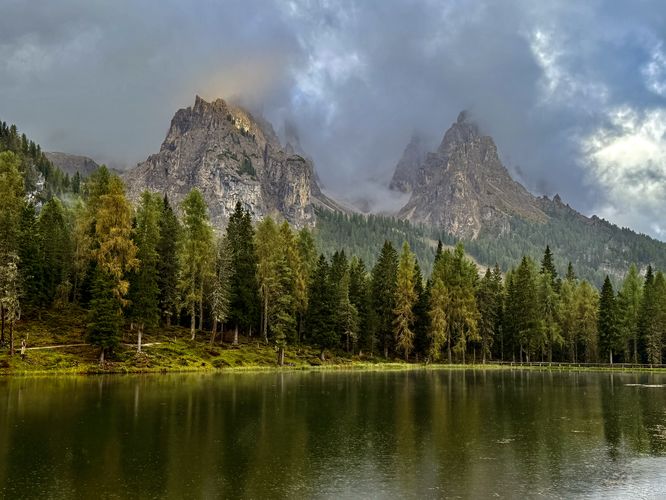
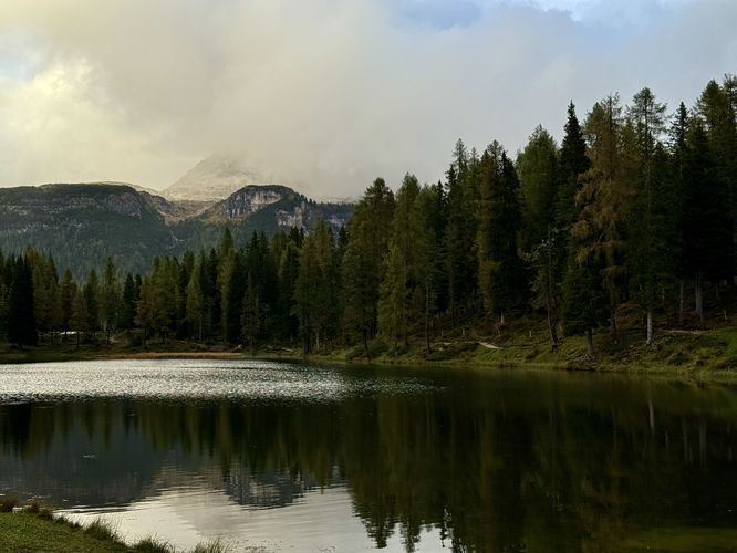
Often considered the quieter, charming sibling to nearby Lake Misurina, Lago d’Antorno offers a peaceful escape and easy lakeside stroll. This gentle, family-friendly trail is an easy 0.72 km (0.45 miles) loop, making it perfect for a leisurely stroll to stretch your legs or a quick stop for photography enthusiasts. The trail circles Lake Antorno on a flat path, allowing you to soak in the reflection of the dramatic limestone peaks that tower over the valley. Whether you are winding down after a long day of hiking or simply looking for a serene picnic spot, Lake Antorno provides high-reward scenery with minimal effort in the heart of the Dolomites.

Walking the Lago d'Antorno Loop: A Scenic Stroll

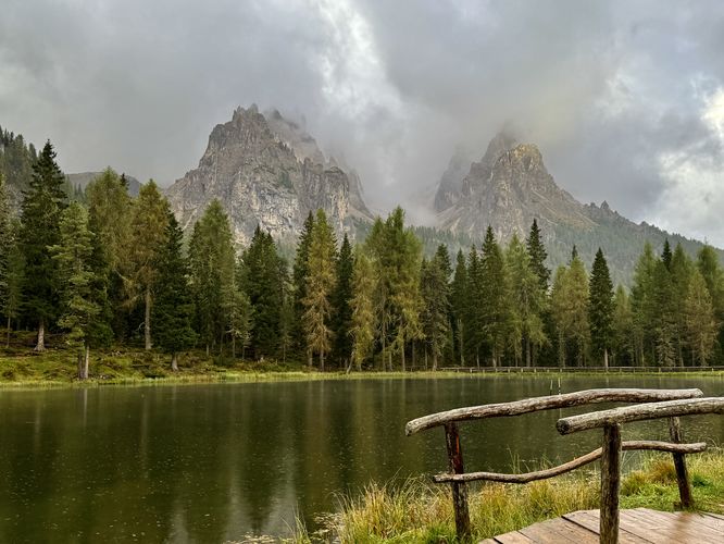
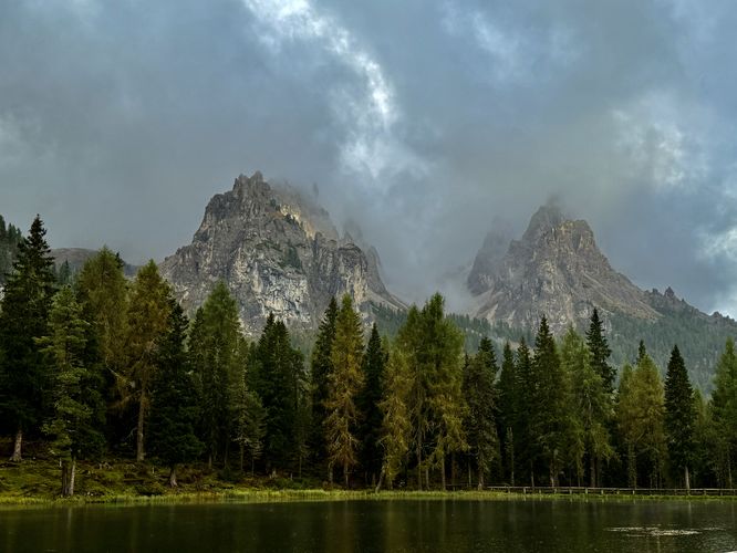
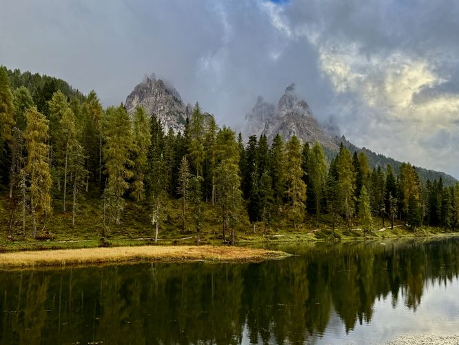
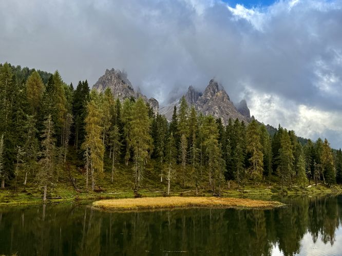
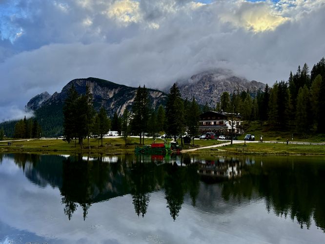
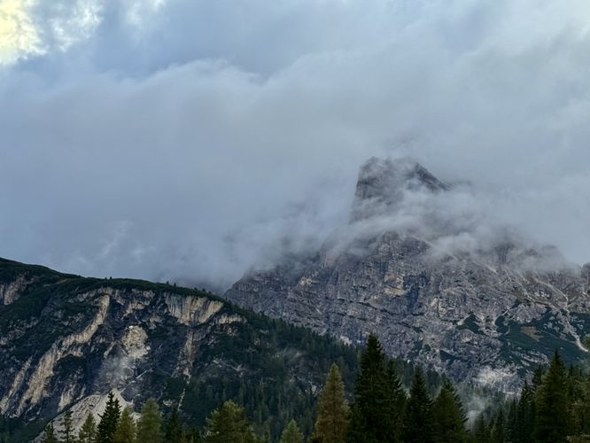
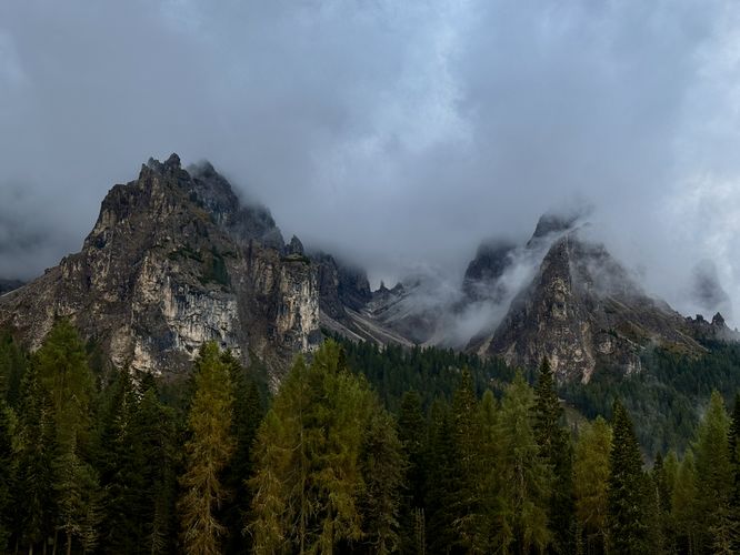
This short walk begins on the west side of Lake Antorno where visitors will find a small public parking lot. The trail leads in both north/south directions, but this trail guide heads north first. Along the Lago d'Antorno Trail, you'll find Alps views to the east of the limestone peaks that tower over the lake. When we arrived near sunset, the sunlight was illuminating the peaks and made for fantastic photo opportunities.

Just below the main path sits a small footbridge that crosses a tributary stream. With the wooden footbridge in the foreground and the majestic Alps of the Dolomites in the background, the western side of Lago d'Antorno is one of the best, easy access locations in the Italian Alps to take photos.

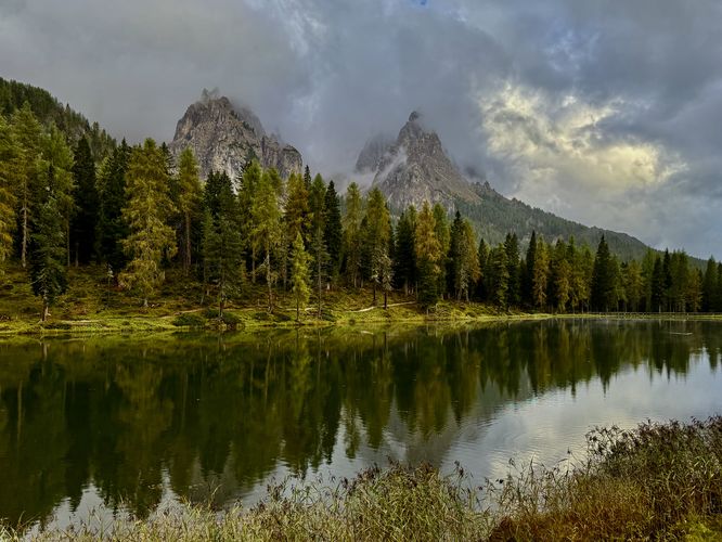
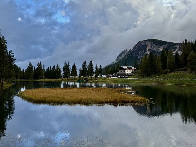
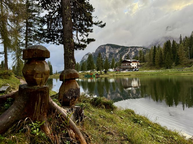
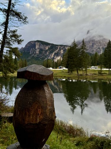
The trail continues north before it curves around the northern shore of Lake Antorno. Eventually, you'll find yourself on the east side of the lake where the trail begins to head south along the water's edge. More Alps views can be found on the east side of Lago d'Antorno and you'll even find fun mushroom-shaped tree stumps that were carved by locals.

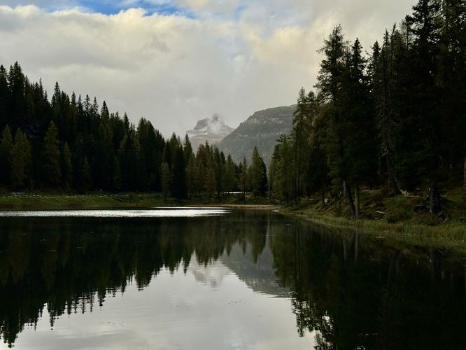
Finally, the trail follows a raised boardwalk on the south shore before it runs along the dirt path to reach the parking lot. Wrap up the trail at 0.72 km (0.45 miles) to complete this easy walk around Lago d'Antorno.

Parking & Directions: Getting to Lake Antorno

Visitors to Lake Antorno will find a small parking lot on the east side of Via Monte Piana, Misurina at the coordinates provided: 46.594658, 12.264238. The parking lot is large enough to fit approximately 20 vehicles as of September 2025.

Pets

Dogs are allowed on the Lago d'Antorno Trail if leashed and must be cleaned up after.

Explore More Stunning Lakes in the Dolomites

No trip to the Italian Alps is complete without touring the region's most spectacular turquoise-hued lakes! While each location offers a unique view of the limestone peaks, they are often just a short drive apart. Enhance your Dolomites adventure itinerary by exploring our complete guides to the best nearby alpine lakes: the world-famous Lago di Braies, the scenic Lago di Dobbiaco, the roadside gem of Lago di Landro, and the majestic Lago di Misurina.
Explore 8 trails near Misurina, Italy
  1. Parking

    46.594658, 12.264238
  2. Main Trailhead

    46.594658, 12.264238
  3. A wooden footbridge and sunlit alpine peaks in the Dolomites at Lake Antorno

    46.594742, 12.264575
    A wooden footbridge and sunlit alpine peaks in the Dolomites at Lake Antorno
  4. View of alpine peaks at Lake Antorno

    46.594764, 12.264583
    View of alpine peaks at Lake Antorno
  5. View of illuminated alpine peaks of the Italian Alps at Lago d'Antorno

    46.595164, 12.264567
    View of illuminated alpine peaks of the Italian Alps at Lago d'Antorno
  6. Another beautiful view of Lago d'Antorno and nearby alpine mountains

    46.595669, 12.265031
    Another beautiful view of Lago d'Antorno and nearby alpine mountains
  7. View from the northwest corner of Lake Antorno with towering alpine peaks

    46.596086, 12.265411
    View from the northwest corner of Lake Antorno with towering alpine peaks
  8. View of Lake Antorno from the north shore

    46.596214, 12.265558
    View of Lake Antorno from the north shore
  9. View of Lake Antorno from the northeast corner

    46.595969, 12.266344
    View of Lake Antorno from the northeast corner
  10. Mushroom-shaped tree stumps at Lake Antorno

    46.595222, 12.266003
    Mushroom-shaped tree stumps at Lake Antorno
  11. A west-facing view of Lake Antorno and nearby alpine peaks

    46.594744, 12.265744
    A west-facing view of Lake Antorno and nearby alpine peaks
  12. Mushroom-shaped tree stump

    46.594386, 12.265628
    Mushroom-shaped tree stump
  13. View of towering alpine peaks above Lake Antorno

    46.594111, 12.265478
    View of towering alpine peaks above Lake Antorno
  14. North-facing view of Lake Antorno and distant alpine mountains

    46.593772, 12.265081
    North-facing view of Lake Antorno and distant alpine mountains
  15. View of Lago d'Antorno with a cloudy Tre Cime di Lavaredo

    46.593989, 12.264514
    View of Lago d'Antorno with a cloudy Tre Cime di Lavaredo
  16. Cloudy view of the alpine peaks east of Lake Antorno

    46.594772, 12.264464
    Cloudy view of the alpine peaks east of Lake Antorno
No community routes found. To add your own hike as a Community Route for this Trail guide, leave a Trip Report with an attached GPX file.

Seasons

All

Photo Albums

+ Add Photo Album

Upload your photos from the trail to help others know what to expect.

Preview of the MyHikes mobile app interface

Track, Log, and Explore Hikes with the MyHikes App

Shop Landscape Prints
Shop our Alps landscape prints to support MyHikes!

Trip Reports (Reviews)

Ready to help fellow hikers? Add a trip report to share your experience and provide valuable insights for those planning their next hike. Your review makes the trail better for everyone.

Your opinion matters! Be the first to rate this trail.

Explore Hiking Trails

You May Also Like

Colorado's Million Dollar Highway - Plan a day's drive adventure along the iconic Million Dollar Highway in Colorado. Explore the best short trails, roadside stops, waterfalls, vistas, ghost towns, and hot springs within a ~6 hour road trip.
Explore

Colorado's Million Dollar Highway

Plan a day's drive adventure along the iconic Million Dollar Highway in Colorado. Explore the best short trails, roadside stops, waterfalls, vistas, ghost towns, and hot springs within a ~6 hour road trip.

Read
Glacier's Going-to-the-Sun Road - Discover the breathtaking beauty of Glacier National Park along the iconic Going-to-the-Sun Road. From stunning roadside stops to picturesque waterfalls and vistas, this engineering marvel offers endless opportunities for exploration.
Explore

Glacier's Going-to-the-Sun Road

Discover the breathtaking beauty of Glacier National Park along the iconic Going-to-the-Sun Road. From stunning roadside stops to picturesque waterfalls and vistas, this engineering marvel offers endless opportunities for exploration.

Read
New York's Best Waterfalls - Whether you're planning a day hike, roadside stop, or a leisurely short walk, this guide provides hikers, travelers, and locals alike with 63 different locations to over 100 scenic waterfalls to help plan your next adventure!
Explore

New York's Best Waterfalls

Whether you're planning a day hike, roadside stop, or a leisurely short walk, this guide provides hikers, travelers, and locals alike with 63 different locations to over 100 scenic waterfalls to help plan your next adventure!

Read

Before you boogie...

Find our trail guides useful? Consider becoming a Supporter to unlock perks!

MyHikes is an indie platform that makes exploring public trails easier for everyone. The platform has no investors, no ads, and is owned and operated by one person, Dave Miller. Dave has personally mapped and written over 1,800 trail guides on MyHikes for the public to explore. MyHikes has helped millions outdoor enthusiasts plan their next adventure.

But it takes a lot of time 🕦, money 💰, work, and espresso shots ☕ to run MyHikes, including hiking , mapping , writing , and publishing new trails with high-quality (accurate) information... along with software engineering (coding) the platform like building new features, website and mobile app development (iOS and Android), site maintainance . and much much more.

Supporters unlock website and mobile app perks with an annual one-time payment of $25 (you renew) 😎👍. Or you can simply make a Donation of your choice. Otherwise, you can support us by telling your friends about MyHikes - both quick and free 🎉

Admin avatar

Dave Miller
MyHikes Founder
🍪 We use cookies to learn about site usage, performance, and to serve map tiles. You may block cookies manually in the browser. By continuing to use MyHikes, you agree. Learn more