Loading...

🌲 WINTER SALE! 50% OFF on Supporter Accounts — now through December 31st. Unlock a full year of exclusive website & app perks for better hikes. Learn More.

Lago di Dobbiaco (Toblacher See) Hike

Directions
Map
Pictures
Download Lago di Dobbiaco (Toblacher See) Hike GPX Data to the MyHikes Mobile App
Distance:
2.7 km / 1.7 Miles
Type:
Loop
Difficulty:
Easy
Time to Hike:
1 hour
Features:
Surface Type:
Dirt
Town:
Dobbiaco, Italy
Get Directions:
46.70491, 12.220249
Added:
September 25, 2025
Updated:
November 23, 2025
Copy Trail Link Hiking this trail? Send a friend or family member a link to this trail guide for your own safety. Hike at your own risk (disclaimer)
Loading...
Loading...
19m

Total Change
32m

Ascent
33m

Descent

Download the GPX Data for Offline Use

Supporters get exclusive access to download trail routes to the MyHikes app for offline use. Stay prepared on your adventure, even without an internet connection! Become a Supporter today to unlock this feature and hike with confidence.

Download Lago di Dobbiaco (Toblacher See) Hike GPX Data to the MyHikes Mobile App

Key Takeaways

  • The Lago di Dobbiaco (Toblacher See) loop is a 2.8 km (1.7 miles) easy hike in the Italian Dolomites, offering a highly accessible path on the eastern shore suitable for wheelchairs and strollers.
  • Experience the tranquil beauty and dramatic alpine views of a Dolomites lake without the large crowds, making it the perfect, quiet follow-up hike after visiting the popular Lago di Braies.
  • The trail features a unique boardwalk section through a marsh and forest on the south shore, plus restaurants and cafes on the north shore for refueling after the scenic walk.

Lago di Dobbiaco (Toblacher See) Hike

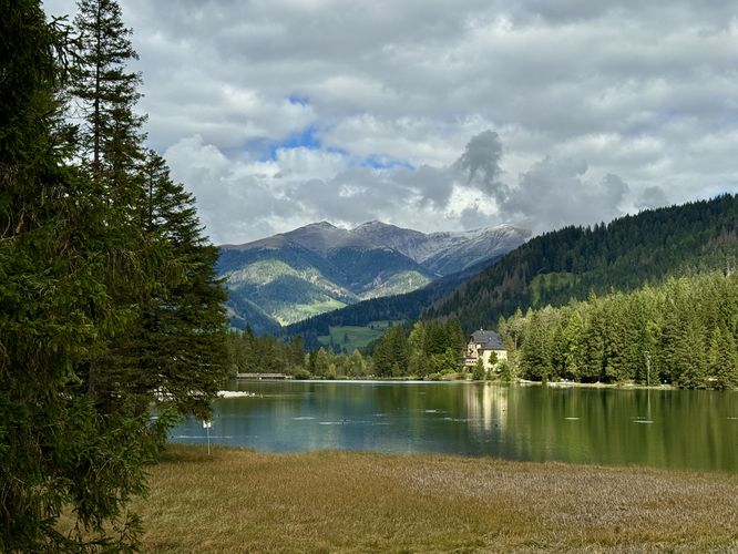
Tucked away just a short drive from the ultra-popular Lago di Braies (Pragser Wildsee), the quiet, secluded waters of Lago di Dobbiaco (Toblacher See) offer a serene and accessible escape into the heart of the 
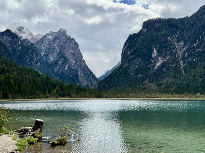
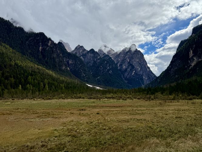
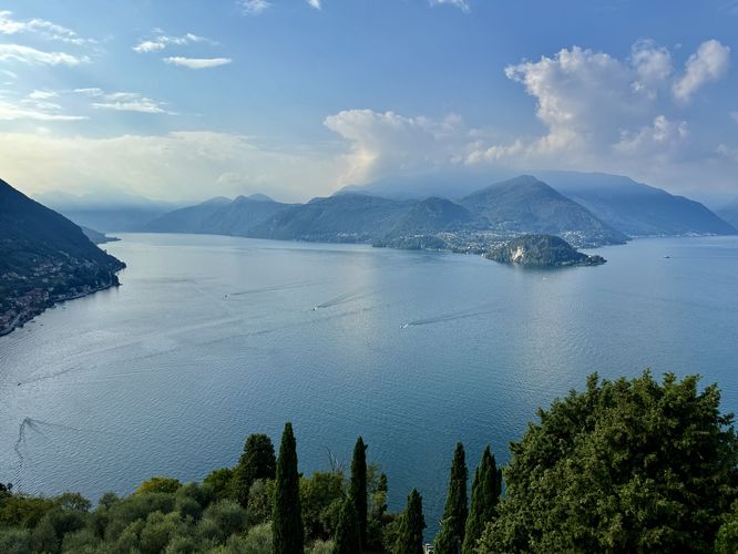
Dolomites. This easy, 2.8 km (1.7 miles) loop trail encircles the lake, providing a peaceful walk for all ages and abilities. Visitors can expect stunning Alps views, from the rich turquoise and emerald hues of the lake's water to the dramatic, towering alpine peaks that guard its southern shore. Unlike its famous neighbor, this path promises a tranquil experience, allowing you to fully soak in the natural beauty without the crowds.

Lago di Dobbiaco (Toblacher See) Trail Guide

This hike begins at the main trailhead, located on the west side of the parking lot where a moderate grade path leads down to the lake's edge. Once you reach the lake shore, you'll be on the loop trail that circles Lago di Dobbiaco. The trail immediately provides hikers with breathtaking views of the lake's turquoise waters and nearby alpine mountains of the Dolomites.

Starting the Loop: The Universally-Accessible East Shore

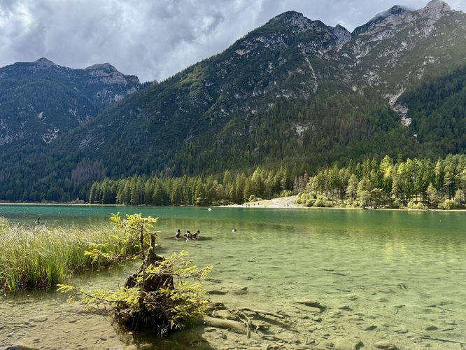
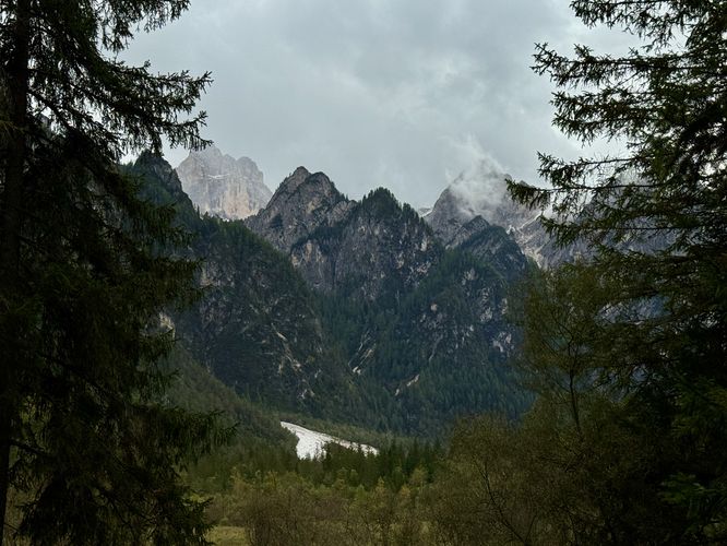
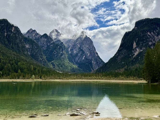
To start the hike on the eastern shore, you'll find a universally-accessible, flat path that heads south along the edge of th lake. Before you start to hike south, visitors will find a couple of viewpoints located just north of the moderate path that leads to the loop trail. Here, you can take photos, facing south, of the towering alpine peaks that stand tall above Lago di Dobbiaco.

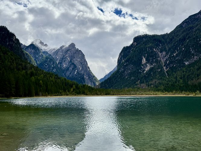
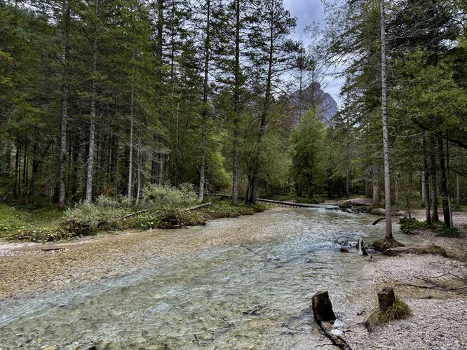
Once you're done taking in the views near the trailhead, the hike leads south as the trail follows a flat, crushed gravel path along the water's edge. As you hike south, you'll find more views of the turquoise-hued lake and breathtaking alpine mountains. Eventually, the trail reaches the southern shoreline of Lago di Dobbiaco where the path begins to lead through a forest.

Exploring the Southern Boardwalk and Marsh

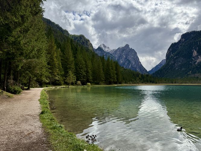
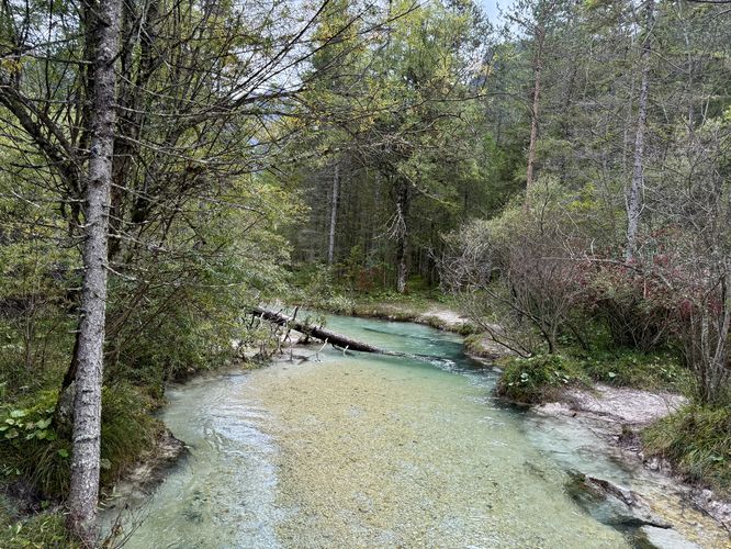
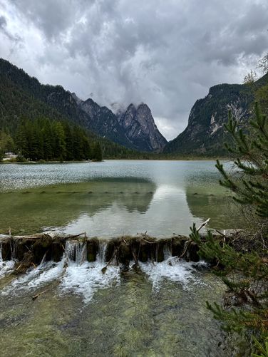
On the south shore of Lago di Dobbiaco, the trail begins to run through an evergreen forest surrounded by sprawling marshlands. Eventually the crushed stone path turns into an easy to follow, accessible boardwalk that leads directly through the forest. Along the way, you'll cross a couple of streams that flow into the lake. These streams, including Fiume Rienza and Sarlbach / Rio di Serla, include crystal-clear turquoise-hued water as well and make for beautiful and peaceful stops along the trail.

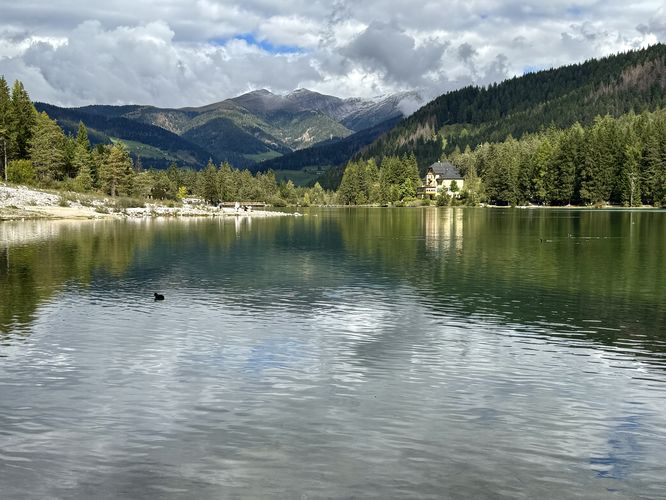
The Western Shore and Observation Deck

Once you reach the western side of the trail, it starts to lead north through the forest to reach an observation deck. This section of the trail is less accessible than the eastern and southern sections, so beware if you're exploring in a wheelchair or have mobility issues. Near 1.8 km from the trailhead sits the wooden observation deck that sits above Lago di Dobbiaco. Here, you can walk up the staircase to reach the viewpoint where you'll find beautiful views of the lake and its surrounding alpine peaks. To the northeast sits the Hotel Baur am See which has unique alpine architecture and simply adds to the lake's scenery. After leaving the observation deck, the trail continues northbound as it runs alongside the water's edge with more views of the lake, its turquoise waters, and alpine views of the Italian Dolomites.

Refuel and Relax: Amenities on the North Shore

As you make your way closer to the north shore, the trail enters a small village with a couple of restaurants. On our hike, we stopped at the restaurant, Chaletdel lago, where we grabbed a bite to eat, a spritz to refresh, and an espresso to refuel. After having a nice lunch, we followed the trail along the north shore, passing more beautiful views of the turquoise Lago di Dobbiaco, before returning to the parking lot to wrap up this fun, secluded, and easy 2.8 km (1.7 mile) hike.

Parking & Directions: How to Get to Lago di Dobbiaco (Toblacher See)

Visitors to Lago di Dobbiaco (Lake Dobbiaco / Toblacher See) will find a large, paid parking lot at the coordinates provided (46.70491, 12.220249). There's a small, hourly fee to park with pay stations located at the parking lot. If you plan to grab a bite to eat at the nearby restaurants, you might want to pay a little bit extra to ensure your ticket covers your entire visit. To get to Lago di Dobbiaco, simply drive down SS51 (Strada Statale 51 di Alemagna)

Universal Access

Visitors should note that the loop trail around Lago di Dobbiaco (Toblacher See) is considered semi universally-accessible. From the parking lot and trailhead, there's a moderate grade that leads down to the lake's shoreline. The eastern side of the lake provides a flat, crushed stone path that features no tripping hazards and should be considered universally-accessible. Eventually the flat crushed gravel path switches to an accessible boardwalk on the south side where the trail leads through a marshland forest. The western side of the trail follows a similar path, but is not as easily accessible as the east side.

Pets

Dogs are allowed only if leashed and must be cleaned up after.

Explore More Stunning Lakes in the Dolomites

No trip to the Italian Alps is complete without touring the region's most spectacular turquoise-hued lakes! While each location offers a unique view of the limestone peaks, they are often just a short drive apart. Enhance your Dolomites adventure itinerary by exploring our complete guides to the best nearby alpine lakes: the world-famous Lago di Braies, the roadside gem of Lago di Landro, the majestic Lago di Misurina, and the serene Lago d'Antorno.
Explore 8 trails near Dobbiaco, Italy
  1. Parking

    46.70491, 12.220249
  2. Main Trailhead

    46.70491, 12.220249
  3. View of Lago di Dobbiaco near the trailhead

    46.704506, 12.219731
    View of Lago di Dobbiaco near the trailhead
  4. View of the turquoise waters of Lago di Dobbiaco with towering peaks of the Dolomites

    46.704119, 12.219986
    View of the turquoise waters of Lago di Dobbiaco with towering peaks of the Dolomites
  5. Another breathtaking view of the turquoise Lago di Dobbiaco

    46.703903, 12.220297
    Another breathtaking view of the turquoise Lago di Dobbiaco
  6. The lake trail leads to more breathtaking views of alpine mountains

    46.703306, 12.221172
    The lake trail leads to more breathtaking views of alpine mountains
  7. Turquoise tributary (Fiume Rienza) of Lake Dobbiaco

    46.698119, 12.219533
    Turquoise tributary (Fiume Rienza) of Lake Dobbiaco
  8. Sarlbach / Rio di Serla

    46.697644, 12.218714
    Sarlbach / Rio di Serla
  9. Moody view of the alpine peaks near Dobbiaco, Italy

    46.700347, 12.215544
    Moody view of the alpine peaks near Dobbiaco, Italy
  10. View of alpine peaks from the sprawling meadow of Lake Dobbiaco

    46.701317, 12.216864
    View of alpine peaks from the sprawling meadow of Lake Dobbiaco
  11. View of the Hotel Baur am See from the observation deck

    46.701336, 12.216864
    View of the Hotel Baur am See from the observation deck
  12. Another view of Lake Dobbiaco and Hotel Baur am See

    46.702144, 12.216969
    Another view of Lake Dobbiaco and Hotel Baur am See
  13. Stunning view of Lago di Dobbiaco and towering alpine peaks of the Dolomites

    46.703228, 12.217069
    Stunning view of Lago di Dobbiaco and towering alpine peaks of the Dolomites
  14. Small dam view on the north side of Lake Dobbiaco

    46.706386, 12.218561
    Small dam view on the north side of Lake Dobbiaco
No community routes found. To add your own hike as a Community Route for this Trail guide, leave a Trip Report with an attached GPX file.

Seasons

All

Photo Albums

+ Add Photo Album

Upload your photos from the trail to help others know what to expect.

Preview of the MyHikes mobile app interface

Track, Log, and Explore Hikes with the MyHikes App

Shop Landscape Prints
Shop our Alps landscape prints to support MyHikes!

Trip Reports (Reviews)

Ready to help fellow hikers? Add a trip report to share your experience and provide valuable insights for those planning their next hike. Your review makes the trail better for everyone.

Your opinion matters! Be the first to rate this trail.

Explore Hiking Trails

You May Also Like

Colorado's Million Dollar Highway - Plan a day's drive adventure along the iconic Million Dollar Highway in Colorado. Explore the best short trails, roadside stops, waterfalls, vistas, ghost towns, and hot springs within a ~6 hour road trip.
Explore

Colorado's Million Dollar Highway

Plan a day's drive adventure along the iconic Million Dollar Highway in Colorado. Explore the best short trails, roadside stops, waterfalls, vistas, ghost towns, and hot springs within a ~6 hour road trip.

Read
Glacier's Going-to-the-Sun Road - Discover the breathtaking beauty of Glacier National Park along the iconic Going-to-the-Sun Road. From stunning roadside stops to picturesque waterfalls and vistas, this engineering marvel offers endless opportunities for exploration.
Explore

Glacier's Going-to-the-Sun Road

Discover the breathtaking beauty of Glacier National Park along the iconic Going-to-the-Sun Road. From stunning roadside stops to picturesque waterfalls and vistas, this engineering marvel offers endless opportunities for exploration.

Read
New York's Best Waterfalls - Whether you're planning a day hike, roadside stop, or a leisurely short walk, this guide provides hikers, travelers, and locals alike with 63 different locations to over 100 scenic waterfalls to help plan your next adventure!
Explore

New York's Best Waterfalls

Whether you're planning a day hike, roadside stop, or a leisurely short walk, this guide provides hikers, travelers, and locals alike with 63 different locations to over 100 scenic waterfalls to help plan your next adventure!

Read

Before you boogie...

Find our trail guides useful? Consider becoming a Supporter to unlock perks!

MyHikes is an indie platform that makes exploring public trails easier for everyone. The platform has no investors, no ads, and is owned and operated by one person, Dave Miller. Dave has personally mapped and written over 1,800 trail guides on MyHikes for the public to explore. MyHikes has helped millions outdoor enthusiasts plan their next adventure.

But it takes a lot of time 🕦, money 💰, work, and espresso shots ☕ to run MyHikes, including hiking , mapping , writing , and publishing new trails with high-quality (accurate) information... along with software engineering (coding) the platform like building new features, website and mobile app development (iOS and Android), site maintainance . and much much more.

Supporters unlock website and mobile app perks with an annual one-time payment of $25 (you renew) 😎👍. Or you can simply make a Donation of your choice. Otherwise, you can support us by telling your friends about MyHikes - both quick and free 🎉

Admin avatar

Dave Miller
MyHikes Founder
🍪 We use cookies to learn about site usage, performance, and to serve map tiles. You may block cookies manually in the browser. By continuing to use MyHikes, you agree. Learn more