Loading...

🎉 Enjoy a Free 7-Day Supporter Trial and Unlock Exclusive Perks — No Credit Card Required. Learn more.

Ice Break Trail

Directions
Map
Pictures
Send to App
Distance:
1.5 Miles / 2.4 km
Type:
Out-and-Back
Difficulty:
Easy
Time to Hike:
~45 minutes
Features:
PA Wilds
Surface Type:
Dirt
Park:
Tioga State Forest
Town:
Gaines, Pennsylvania
Directions:
41.65569, -77.482521
Added:
October 12, 2020
Updated:
April 08, 2021
Copy Trail Link Hiking this trail? Send a friend or family member a link to this trail guide for your own safety. Hike at your own risk (disclaimer)
Loading...
Loading...
39'

Total Change
100'

Ascent
102'

Descent

Download the Trail Route for Offline Use

Supporters get exclusive access to download trail routes to the MyHikes app for offline use. Stay prepared on your adventure, even without an internet connection! Become a Supporter today to unlock this feature and hike with confidence.

Send to App

Ice Break Trail

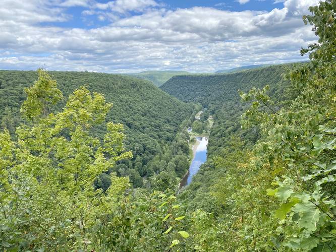
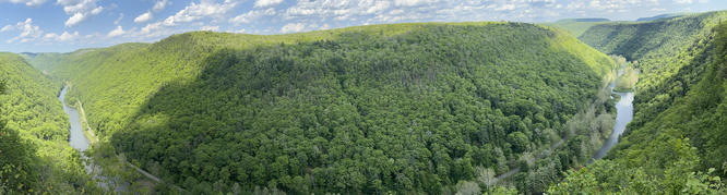
The Ice Break Trail at Tioga State Forest near Gaines, Pennsylvania is an easy 1.5-mile out-and-back trail that leads from Painter-Leetonia Road out to the West Rim Trail to a nice vista point above Pine Creek at Pine Creek Gorge (PA Grand Canyon).

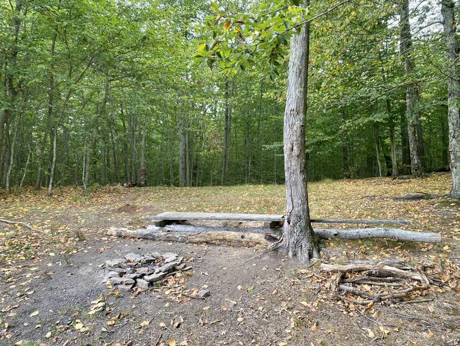
This trail does not have much to note other than it's a nice peaceful mostly-flat hike. At the end of the trail is the vista point and a campsite along the West Rim Trail, along with a trail registry box.

Parking
Hikers will find a tiny parking turnout next to the trailhead. This parking turnout can fit about 2 vehicles max. Do not block the road or park down the road if parking is full.

Backpacking and Camping
Backpackers will find a campsite at the end of this trail. There are also plenty of flat spots off-trail where you can likely setup a tent or hammock as well. Please follow all state forest rules and regulations for dispersed / backcountry / primitive camping.

Pets
Dogs are allowed if leashed.

Blaze Color
This trail follows yellow blazes.

Winter Maintenance
The state forest does not maintain this road during the winter. Do not attempt to drive this road without the proper equipment.
Explore 275 trails near Gaines, PA
  1. Parking

    41.65569, -77.482521
  2. Main Trailhead

    41.655671, -77.48266
  3. Vista along West Rim Trail

    41.658181, -77.471436
    Vista along West Rim Trail
  4. Campsite along West Rim Trail

    41.658161, -77.471367
    Campsite along West Rim Trail
No community routes found. To add your own hike as a Community Route for this Trail guide, leave a Trip Report with an attached GPX file.

Hazards

Ticks - Lyme Disease More Info (CDC)
Poison Ivy/Oak

Seasons

All

Blaze Color

Yellow

Photo Albums

Trip Reports

Trail Guide By:
Admin user profile picture
1.5 miles / 2.4 km
1.5 miles / 2.4 km
July 18, 2023
Found heaps of black trumpet mushrooms and a few chanterelles.
Hiking
1.5 miles / 2.4 km
August 30, 2020
Dogs Hiking

Weather Forecast

In Gaines, PA

Explore Hiking Trails

You May Also Like

Colorado's Million Dollar Highway - Plan a day's drive adventure along the iconic Million Dollar Highway in Colorado. Explore the best short trails, roadside stops, waterfalls, vistas, ghost towns, and hot springs within a ~6 hour road trip.
Explore

Colorado's Million Dollar Highway

Plan a day's drive adventure along the iconic Million Dollar Highway in Colorado. Explore the best short trails, roadside stops, waterfalls, vistas, ghost towns, and hot springs within a ~6 hour road trip.

Read
New York's Best Waterfalls - Whether you're planning a day hike, roadside stop, or a leisurely short walk, this guide provides hikers, travelers, and locals alike with 63 different locations to over 100 scenic waterfalls to help plan your next adventure!
Explore

New York's Best Waterfalls

Whether you're planning a day hike, roadside stop, or a leisurely short walk, this guide provides hikers, travelers, and locals alike with 63 different locations to over 100 scenic waterfalls to help plan your next adventure!

Read

Before you boogie...

Find our trail guides useful? Consider becoming a Supporter to unlock perks!

MyHikes is an indie platform that makes exploring public trails easier for everyone. The platform has no investors, no ads, and is owned and operated by one person, Dave Miller. Dave has personally mapped and written over 1,800 trail guides on MyHikes for the public to explore. MyHikes has helped millions outdoor enthusiasts plan their next adventure.

But it takes a lot of time 🕦, money 💰, work, and espresso shots ☕ to run MyHikes, including hiking , mapping , writing , and publishing new trails with high-quality (accurate) information... along with software engineering (coding) the platform like building new features, website and mobile app development (iOS and Android), site maintainance . and much much more.

Supporters unlock website and mobile app perks with an annual one-time payment of $25 (you renew) 😎👍. Or you can simply make a Donation of your choice. Otherwise, you can support us by telling your friends about MyHikes - both quick and free 🎉

Admin user profile picture

Dave Miller
MyHikes Founder