The Ice Break Run Waterfalls at Tioga State Forest in Gaines, Pennsylvania is a moderate 2.4-mile out-and-back hike that requires off-trail exploration and features three waterfalls along Ice Break Run - Ice Break Falls, Fern Gully Falls, and Scramble Falls.
Please note that this hike is meant only for the experienced hiker who's comfortable with creek hiking, scrambling, and off-trail navigation.
Trails
This hike follows two named trails before the off-trail section: Ice Break Trail (yellow blazes), West Rim Trail (orange blazes).
Hike Description
This hike begins along Painter-Leetonia Road at the trailhead for the Ice Break Trail and follows the yellow blazes of the Ice Break Trail for its entire length before reaching a junction with the West Rim Trail.
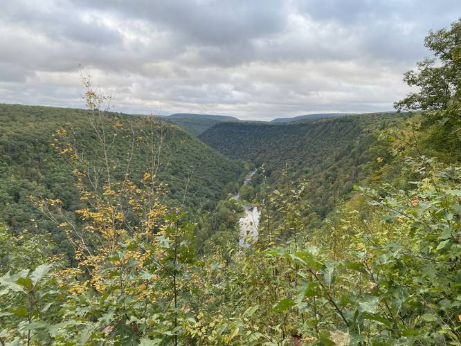
Vista - Mile 0.7
At mile 0.7, where the Ice Break Trail meets the West Rim Trail is a nice vista of the PA Grand Canyon (Pine Creek Gorge).
Off-Trail Turn - Mile 0.93
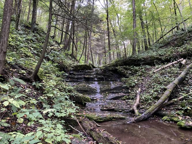
After visiting the vista and campsite area at the junction with the West Rim Trail (WRT), hikers will head south along the WRT for 0.23 miles until they reach a left-hand turn around mile 0.93. This turn is noted by a seasonal creek that spills down a rocky "path" during drier months. Hikers will make their way down this rocky path, likely passing blowdown trees and other obstacles, before the rocky path turns back into what appears to be an old logging grade. Just beyond here is where hikers reach Ice Break Run and the first waterfall, Ice Break Falls.
Ice Break Falls - Mile 1.12
Once the hiker reaches Ice Break Run, Ice Break Falls will present itself just upstream from where the off-trail walk leads to the creek, located around mile 1.12. Ice Break Falls is about 10-feet tall. During dry seasons, the waterfall is not much more than a trickle; however, during the early Spring, while the waterfall may be at its strongest, this creek is also likely very unsafe due to high water levels.
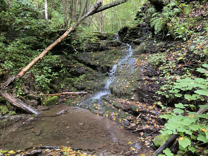
Fern Gully Falls - Mile 1.16
After visiting Ice Break Falls, hikers may want to explore more down Ice Break Run to see the last two waterfalls - the first of which is named Fern Gully Falls. Fern Gully Falls is about 9-feet tall, slightly shorter than Ice Break Falls, and gets its name from the surrounding fern-filled rocks. Please note that to fully enjoy Fern Gully Falls from its base, hikers will need to risk a steep hillside descent that runs down to the waterfall. The safest way down is to take a wide angle up the hillside on the north side of the creek and then head down around the large grouping of trees - skipping the steepest section along the way.
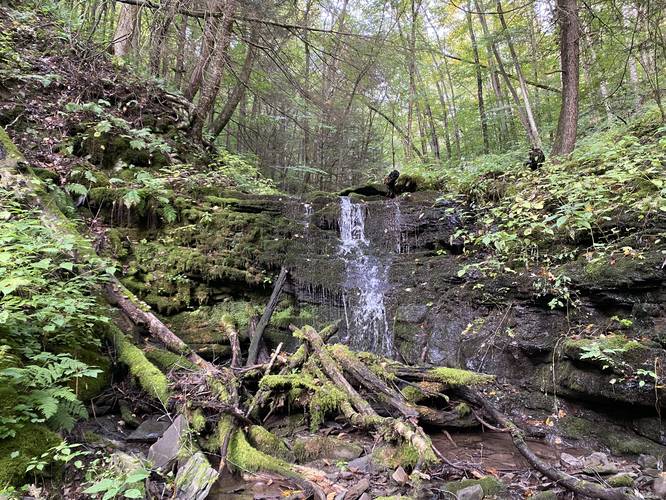
Scramble Falls - Mile 1.19
After visiting Fern Gully Falls, hikers may want to risk another descent to view Scramble Falls, which is about 12-feet tall, located around mile 1.19. Given its name, reaching the base of Scramble Falls is not easy - it requires a precarious ledge drop at about 3-feet tall with two flat footholds, which is the easy part. Just below the rock ledge is a steep hill that plunges down to the waterfall. Hikers will want to take each step very carefully to test the ground below their feet to ensure they don't cause a miniature landslide, as the hillside's soil here can be very loose especially within the last 5-feet of reaching the base of the waterfall. Take your time, watch your step, and carefully descend to the base of Scramble Falls to enjoy the water scramble its own way down the moss and fern-filled rock ledges.
Hiking Out
The hike out is the opposite hike in, but it's not easy. The climb up from Scramble Falls can be a bit tricky and if you take the wrong route up and around Fern Gully Falls, hikers may place themselves in a very steep terrain situation. Take your time and evaluate the terrain and path you take back up the creek to ensure a safe hike.
Parking
Hikers will find a small parking turnout at the coordinates provided. The turnout is large enough for just two or three vehicles max.
Warnings
Timber Rattlesnakes: This area is home to the Timber Rattlesnake which are out roaming between late April and early October. Be on the lookout and listen for rattlers. Keep your distance if you find one.
Slippery and steep, creek terrain: This hike follows some areas where you can only reach the next waterfall by creek hiking. The creek is generally very slippery and can cause injuries fairly easily and quickly. Additionally, the terrain near the creek can be very steep with some plunges that lead 15 feet down to the rocky creek bed below. This hike is not for the beginner hiker or one who's not comfortable in this type of terrain.
Flash floods: While rare, flash flooding does occur in this area and has been known to wipe out road bridges that cross creeks just like this one. Hikers should be aware of any incoming weather and plan their hike accordingly to avoid any chance of flash flooding.
Pets
Dogs are allowed if leashed; however, this hike may be dangerous for hikers with dogs due to the cautions one should take when creek hiking.
Camping and Backpacking
There's a campsite located at the vista along the West Rim Trail. Also note that dispersed / primitive / backcountry camping is allowed at Tioga State Forest, but hikers must follow all posted rules and regulations.
Please note that this hike is meant only for the experienced hiker who's comfortable with creek hiking, scrambling, and off-trail navigation.
Trails
This hike follows two named trails before the off-trail section: Ice Break Trail (yellow blazes), West Rim Trail (orange blazes).
Hike Description
This hike begins along Painter-Leetonia Road at the trailhead for the Ice Break Trail and follows the yellow blazes of the Ice Break Trail for its entire length before reaching a junction with the West Rim Trail.
Vista - Mile 0.7
At mile 0.7, where the Ice Break Trail meets the West Rim Trail is a nice vista of the PA Grand Canyon (Pine Creek Gorge).
Off-Trail Turn - Mile 0.93
After visiting the vista and campsite area at the junction with the West Rim Trail (WRT), hikers will head south along the WRT for 0.23 miles until they reach a left-hand turn around mile 0.93. This turn is noted by a seasonal creek that spills down a rocky "path" during drier months. Hikers will make their way down this rocky path, likely passing blowdown trees and other obstacles, before the rocky path turns back into what appears to be an old logging grade. Just beyond here is where hikers reach Ice Break Run and the first waterfall, Ice Break Falls.
Ice Break Falls - Mile 1.12
Once the hiker reaches Ice Break Run, Ice Break Falls will present itself just upstream from where the off-trail walk leads to the creek, located around mile 1.12. Ice Break Falls is about 10-feet tall. During dry seasons, the waterfall is not much more than a trickle; however, during the early Spring, while the waterfall may be at its strongest, this creek is also likely very unsafe due to high water levels.
Fern Gully Falls - Mile 1.16
After visiting Ice Break Falls, hikers may want to explore more down Ice Break Run to see the last two waterfalls - the first of which is named Fern Gully Falls. Fern Gully Falls is about 9-feet tall, slightly shorter than Ice Break Falls, and gets its name from the surrounding fern-filled rocks. Please note that to fully enjoy Fern Gully Falls from its base, hikers will need to risk a steep hillside descent that runs down to the waterfall. The safest way down is to take a wide angle up the hillside on the north side of the creek and then head down around the large grouping of trees - skipping the steepest section along the way.
Scramble Falls - Mile 1.19
After visiting Fern Gully Falls, hikers may want to risk another descent to view Scramble Falls, which is about 12-feet tall, located around mile 1.19. Given its name, reaching the base of Scramble Falls is not easy - it requires a precarious ledge drop at about 3-feet tall with two flat footholds, which is the easy part. Just below the rock ledge is a steep hill that plunges down to the waterfall. Hikers will want to take each step very carefully to test the ground below their feet to ensure they don't cause a miniature landslide, as the hillside's soil here can be very loose especially within the last 5-feet of reaching the base of the waterfall. Take your time, watch your step, and carefully descend to the base of Scramble Falls to enjoy the water scramble its own way down the moss and fern-filled rock ledges.
Hiking Out
The hike out is the opposite hike in, but it's not easy. The climb up from Scramble Falls can be a bit tricky and if you take the wrong route up and around Fern Gully Falls, hikers may place themselves in a very steep terrain situation. Take your time and evaluate the terrain and path you take back up the creek to ensure a safe hike.
Parking
Hikers will find a small parking turnout at the coordinates provided. The turnout is large enough for just two or three vehicles max.
Warnings
Timber Rattlesnakes: This area is home to the Timber Rattlesnake which are out roaming between late April and early October. Be on the lookout and listen for rattlers. Keep your distance if you find one.
Slippery and steep, creek terrain: This hike follows some areas where you can only reach the next waterfall by creek hiking. The creek is generally very slippery and can cause injuries fairly easily and quickly. Additionally, the terrain near the creek can be very steep with some plunges that lead 15 feet down to the rocky creek bed below. This hike is not for the beginner hiker or one who's not comfortable in this type of terrain.
Flash floods: While rare, flash flooding does occur in this area and has been known to wipe out road bridges that cross creeks just like this one. Hikers should be aware of any incoming weather and plan their hike accordingly to avoid any chance of flash flooding.
Pets
Dogs are allowed if leashed; however, this hike may be dangerous for hikers with dogs due to the cautions one should take when creek hiking.
Camping and Backpacking
There's a campsite located at the vista along the West Rim Trail. Also note that dispersed / primitive / backcountry camping is allowed at Tioga State Forest, but hikers must follow all posted rules and regulations.