Hooper Bald is located south of Huckleberry Knob across the Cherohala Skyway and is also reached by a short, easy hike. Although not as scenic from the summit — few mountains are — it is still worth the quick trip while you are touring the many sights of the national scenic byway. The summit features an immense, rectangular grassy bald from west to east, culminating in views north of Huckleberry Knob and west of Haw Knob. This is a great spot for camping and stargazing if you are looking for a quick, overnight trip.
-
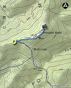
Mile 0.0 – Park at the Hooper Bald Trailhead and picnic area. The Hooper Bald Trail [60] begins on the right side of the information kiosk.
-
Mile 0.05 – T-junction with the King Meadows Trail [63] on the right. This is one of the most remote and underutilized trails in Nantahala National Forest. You will pass through a curious mix of hardwoods and dense, scraggly vines seen on the south slopes of many of the highest Unicoi peaks.
-
Mile 0.1 – Walk straight across FR 2807.
-
Mile 0.4 – Emerge from the forest onto the beginning of the bald portion of Hooper Bald. Turn right following the wide rectangular strip of grass east.
-
Mile 0.5 – The high point of Hooper Bald (5,429 feet) is located on the right near a small rock outcrop with views south.
-
Mile 0.65 – The trail peters out on the northeast side of Hooper Bald. The summit of Huckleberry Knob looms above the tree line due north. Towards the west Laurel Knob and Haw Knob rise above Big Junction and the highest elevation of the Cherohala Skyway. On the right of Haw Knob, Little Haw Knob and Johns Knob surround Mud Gap, the trailhead for hiking to Whigg Meadow.
- Mile 1.2 – Hike ends at the Hooper Bald Trailhead.