Loading...

WINTER SALE! 50% OFF Supporter Accounts — now through January 31st. Learn More.

Helsana Trail

Experience one of Switzerland's most captivating short hikes on the Helsana Trail loop in Filzbach, Glarus Nord. This easily accessible 2.4 km (1.5 mile) route is perfect for visitors looking to combine stunning natural beauty with a short forest hike.

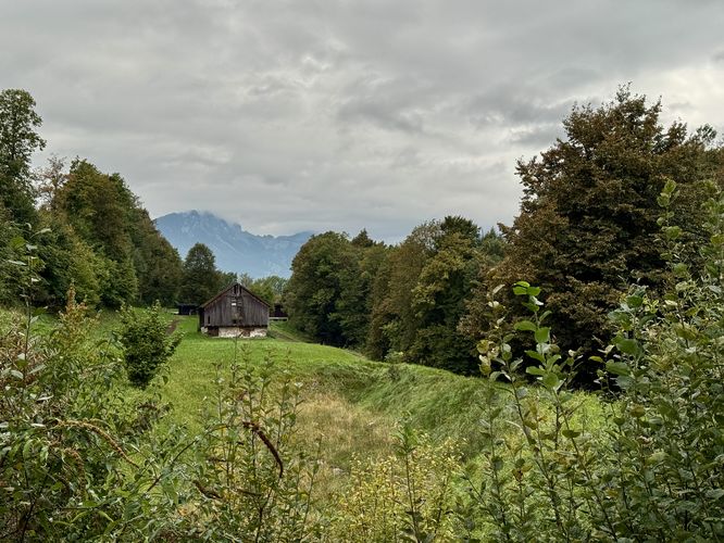
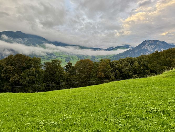
Starting and ending near the charming village of Filzbach, this well-maintained trail offers panoramic lookouts over the striking turquoise waters of Walensee and the surrounding Alpine landscape. The main highlight is the breathtaking, distant view of Seerenbach Falls (Seerenbachfälle), one of Switzerland’s tallest waterfalls at 585 meters (1,919 feet). Whether you are staying at the nearby Seminarhotel Lihn or just looking for a rewarding day hike with unparalleled Swiss views, this loop delivers a perfect mix of forest paths, open meadows, and iconic mountain scenery.

Trail Overview and Key Highlights

This hike begins along Panoramastrasse where hikers will walk down the main road, passing Seminarhotel Lihn on their way downhill. If you're staying at Seminarhotel Lihn like we did, then the hike begins right outside of the hotel's doors.

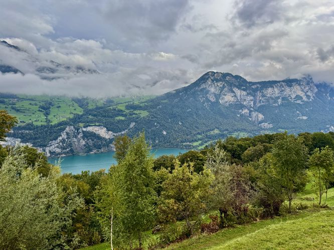
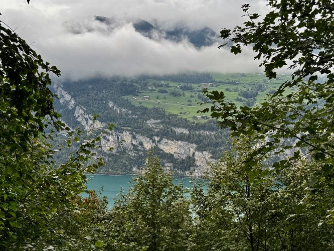
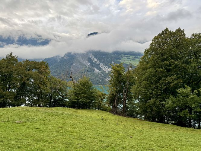
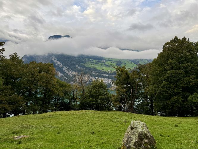
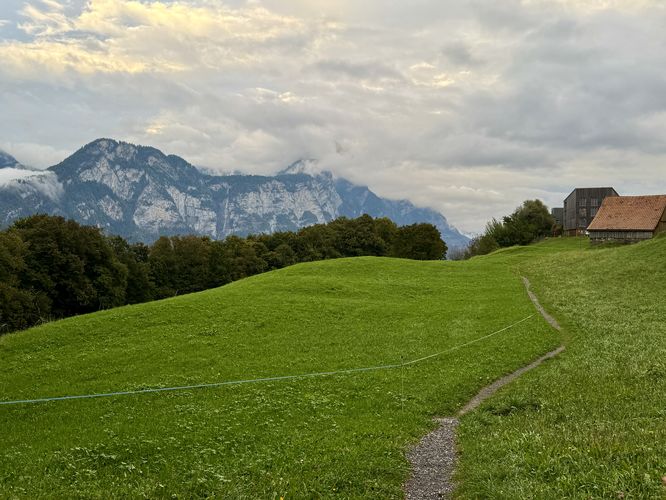
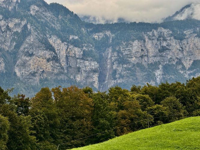
As you hike down the public road, you'll find some of the best views of the turquoise waters of Walensee, in addition to Switzerland's 2nd-tallest waterfall, Seerenbach Falls. Located across the valley, Seerenbach Falls spills down several tiers of cascades with its total height reaching 585-meters (1,919-feet). The massive plummet of Seerenbach Falls cannot be missed and the views of the turquoise waters of Walensee, with the hanging valley village of Amden, are unmatched.

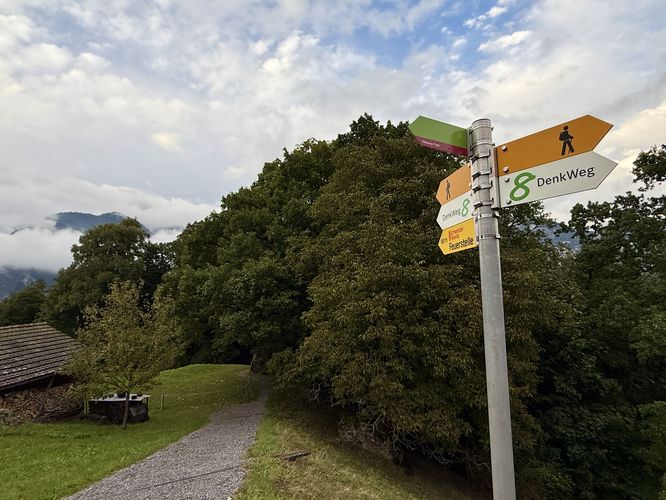
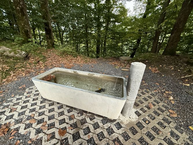
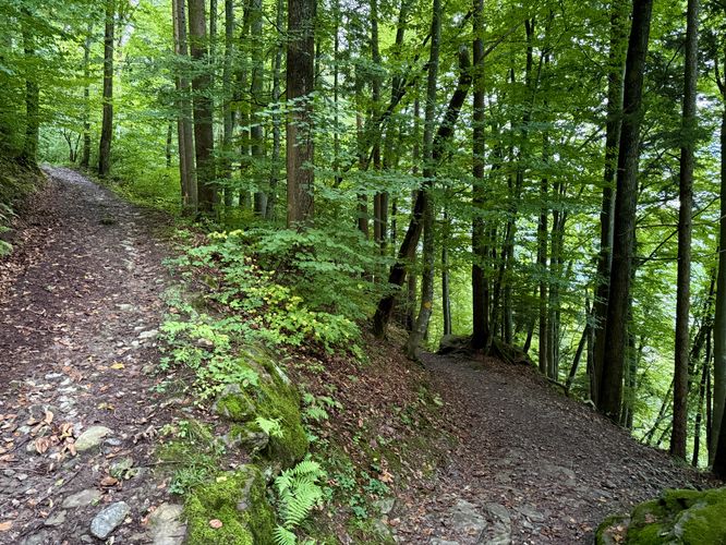
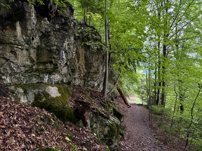
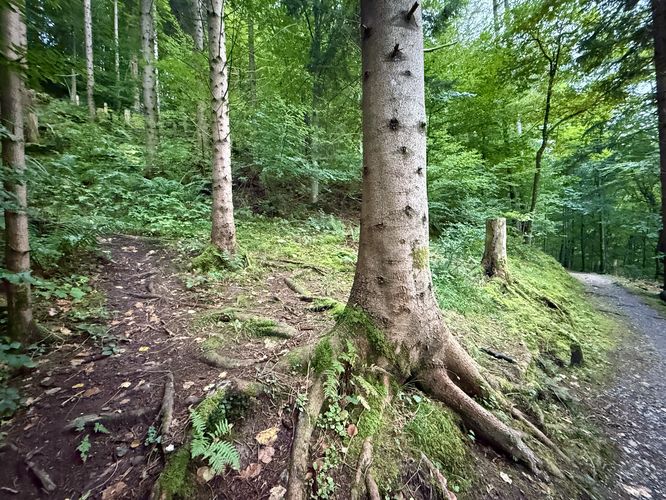
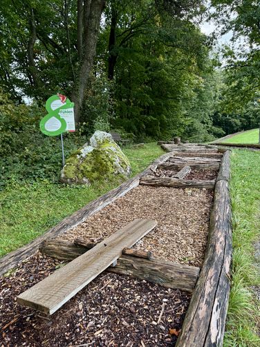
The trail curves around a couple of bends, with more views along the way, before you reach an official trailhead near 0.6 km. Here, the Helsana Trail leads hikers into the woods where you'll find a small "outdoor classroom" that sits next to a water trough. If you're in need of filterable water, the water trough can be used to refill your water bottle - just make sure you use a filter just in case.

Walensee Viewpoint - 0.75 km

After entering the forest, you'll find a small off-shoot trail that leads to a viewpoint high above Walensee. At the viewpoint, you'll find a bench and a large horn-shaped wooden object that appears to be used for fun - communicating a message to the valley below or simply looking through the cone-shaped wooden structure to enjoy the view. Walensee's turquoise waters sit below the lookout and across the valley sits the hanging valley village of Amden, Switzerland.

Keep-Right at Junction - 1.08 km

As you hike further west along the Helsana Trail, it eventually reaches a fork. Here, keep-right at the fork to hike downhill slightly. You know you're on the correct trail when you pass a rock ledge soon after the fork.

Obstructed Walensee Viewpoint - 1.24 km

Near 1.24 km from the trailhead, hikers will reach another viewpoint of Walensee and Amden, but this time it's a bit more obstructed than the previous. Hike through the open meadow to find scenic Swiss Alps views along the way.

Hiking Uphill - 1.5 km

Just west of the open meadow view of Walensee and Amden, the trail will lead uphill near 1.5 km. As of September 2025, the left-hand turn to hike uphill followed an unmaintained path and was easy to miss. If you accidentally skip this turn, you'll find a maintained trail junction just a bit further ahead. Follow the trail as it leads uphill following switchbacks along the way.

Meadows, Playground, and Views - 1.72 to 2 km

Once the trail leads to the top of the hill, it ends up in another wide open meadow. Here, you'll find a small playground and a well-defined trail that leads around the meadow. On the east side of the meadow sits a nice view to the west of a barn and Swiss mountains in the distance. Continue along the Helsana Trail to hike through another large, open meadow with more views of the 585-meter (1,919-foot) tall waterfall, Seerenbach Falls. On the east side of the meadow, the trail leads back onto the road, Panoramastrasse.

Return Hike to Parking - 2 to 2.4 km

Once you reach Panoramastrasse, the hike leads past Seminarhotel Lihn before it curves up the road to reach the center of Filzbach. The hike ends back at the parking lot in Filzbach for a moderate 2.4 (1.5 mile) loop hike.

Parking & Directions: How to Get to the Helsana Trail

Visitors in Filzbach will find several parking lots along the roads: Panoramastrasse / Stalden. Note that some of these parking lots are privately-owned and are not public parking spaces. Please check before leaving your vehicle. For visitors to Seminarhotel Lihn, the hotel provides designated parking spaces. I highly recommend you take public transportation to reach the trailhead as the parking lots along the road may only be private access.

Pets

Dogs are allowed only if leashed and must be cleaned up after.
Explore 3 trails near Glarus Nord, Switzerland

Know Before You Go

  • Hike the Filzbach Helsana Trail for unbeatable panoramic lookouts over the turquoise Walensee and a distant view of the spectacular 585-meter Seerenbach Falls (Seerenbachfälle), one of the highest waterfalls in Switzerland.
  • This moderate 2.4 km (1.5 mile) loop is an ideal, short Glarus Nord day trip suitable for visitors of all skill levels, offering a perfect mix of forest trails and scenic alpine meadows.
  • A highly recommended, convenient route for guests seeking a rewarding outdoor activity, this loop trail is directly accessible from the Seminarhotel Lihn along Panoramastrasse in Filzbach.
Interactive topographic map for Helsana Trail located in Glarus Nord, Switzerland. Click the "View Map" button to load GPS coordinates and trail markers.
Get directions
Distance
2.4 km
Difficulty
Moderate
Type
Loop
Est. Time
45 min
Elev. Gain
92m
Rating
0.0
Added
September 26, 2025
Updated
December 14, 2025
Loading...
Total Change
85m
Ascent
92m
Descent
94m
Loading...

Download the GPX Data for Offline Use

Supporters get exclusive access to download trail routes to the MyHikes app for offline use. Stay prepared on your adventure, even without an internet connection! Become a Supporter today to unlock this feature and hike with confidence.

Download Helsana Trail GPX Data to the MyHikes Mobile App

Features

Vista / Lookout Point
Dogs
Water Source

Points of interest

  1. Parking

    47.121346, 9.127109
  2. Main Trailhead

    47.121527, 9.127128
  3. View of Walensee and Seerenbach Falls

    47.123249, 9.127646
    View of Walensee and Seerenbach Falls
  4. Trailhead for Helsana Trail

    47.123497, 9.130961
    Trailhead for Helsana Trail

Safety information

For your own safety: plan ahead, let someone know where you'll be, and hike at your own risk.

Availability

All seasons

Surface type

Dirt

Trip Reports (Reviews)

Your opinion matters! Be the first to rate this trail.

Ready to help fellow hikers? Add a trip report to share your experience and provide valuable insights for other hikers!

No community routes found. To add your own hike as a Community Route for this Trail guide, leave a Trip Report with an attached GPX file.

Popular categories

Scenic mountain view representing vista trails
Vista trails
Scenic gorge of cascades representing waterfall trails
Waterfall hikes
Rugged mountain terrain representing summit trails
Summit trails
Scenic mountain view representing dog-friendly trails
Dog-friendly
Scenic campsite with a view representing camping trails
Camping trails
Appalachian Trail logo representing A.T. hikes
A.T. hikes

You May Also Like

🍪 We use cookies to learn about site usage and to serve map tiles. You may block cookies manually in the browser. By continuing you agree. Learn more