The Haunted Vista via the Mid State Trail (MST) at Tioga State Forest in Morris, Pennsylvania is a moderate 4-mile loop trail that features several points of interest along the hike including a unique vista point named the Haunted Vista. Hikers should also note there's a shorter alternative route to reach the same vista: Haunted Vista via Anna S Rd.
The Haunted Vista is an old mining tailing (mining spoils) dump along the mountainside that features panoramic views of the mountains in Antrim, PA and the Wilson Creek valley. The hike also includes a rock crevasse traverse, an old mine named the "Anna S. Mine", an old mine runoff creek (treated with chemicals to correct the water's pH), and an open area with views along a service road.
Alternative Routes
Please see our other guides for reaching the Haunted Vista through via different routes: Haunted Vista via Haunted Mine Trail or the Haunted Vista via Anna S Road.
Trail Description
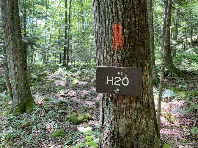
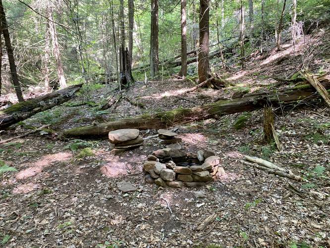
This hike begins along Rattler Road in Morris, PA and follows the Mid State Trail, heading north, toward the Haunted Vista. The first section of the trail is fairly boring compared to the rest of the hike -- hikers will meander their way through the forest, passing some short rock ledges, before the trail heads downhill into a ravine. This ravine follows Basswood Run creek and features a water source for filtering water or refilling your bottle on the south side just before the creek crossing (heading north). It also features a campsite on the north side of Basswood Run.
Continuing onward from Basswood Run, hikers will hike up what appears to be an old log slide. The trail will take a right-hand turn - so be on the lookout for orange blazes and a turn along the trail since it can be easy to miss this turn.
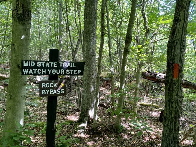
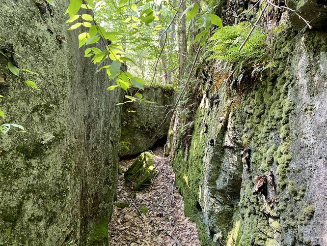
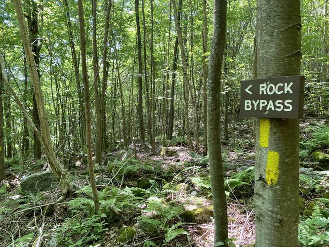
Not long after the hiker leaves the old log slide, the trail will reach a yellow blazed sign labled "Rock Bypass" -- this trail leaves the Mid State Trail and meanders through the rock ledges on the mountainside. This hike skips the yellow blazed Rock Bypass Trail and continues following the Mid State Trail. Hikers must be careful here as most of the rock crevasses are at least 5-feet deep, if not more, making it easy to trip and fall. Dog owners must also be careful if they bring their dogs along for this hike.
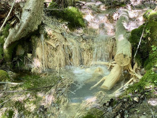
Immediately after reaching the opposite end of the Rock Bypass, hikers will reach another creek crossing -- but this time, the water flows a blue-ish white color. The white-colored water is a reminder that some miners did die hundreds of feet underground here while working the Anna S. Mine; however, this white water is due to a water treatment process to correct the mine water runoff's pH levels to where fish and other creatures can live in the water.
Just after crossing the ghost water creek, hikers will find some large mining slag dumped alongside the trail. Shortly after that, the trail will open up slightly with less trees as it heads uphill for about 100-feet. Near the top of this hill is the old Anna S. Bucket Tram. This bucket tram used to haul coal and other materials from the western mountain tops, across the Wilson Creek valley and over to the eastern mountain tops where it would be transported by the New York Central railroad in Antrim, PA.
Reaching the Haunted Vista
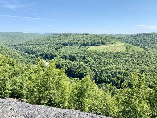
Finally, hikers will reach the Haunted Vista just beyond the old Anna S. Bucket Tram building. This vista point is an odd, but stunning spot to take in views of the Wilson Creek valley and the mountains in Antrim, Pennsylvania. During the Summer, this vista is intensely hot because of the old mining tailings (mining spoils) soaking up the sunlight, so hiking this during the cooler months is recommended. Also note that, with a keen eye, you can spot this vista from PA Route 287 below.
Hiking out from the Haunted Vista
Last, the hiker needs to find their way back to parking. This track follows a forest service road instead of taking the Mid State Trail back. This way back is a bit confusing so understanding the turns is critical to not getting lost.
From the Haunted Vista, hikers will want to head back south toward the Anna S. Bucket Tram building - instead of heading directly to the building, hike up the hill on the right-hand side of this fork in the trail. The trail will lead up to some concrete structures. From here, continue hiking uphill until you reach another junction -- at this junction, take a left-hand turn to head south.
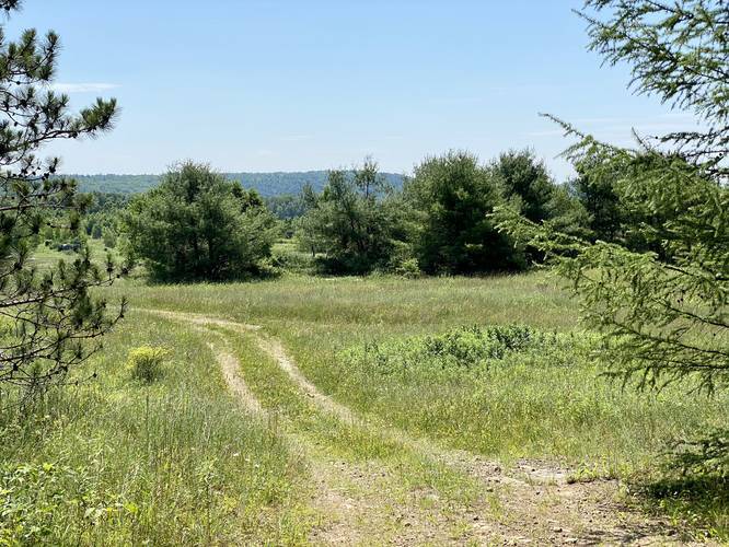
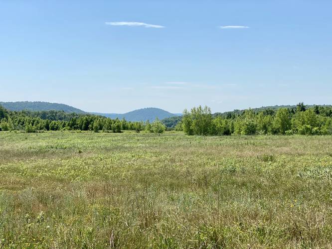
The trail will continue heading south until it reaches yet another junction -- this trail junction has views and open fields to the left-hand side (which can be distracting) as it meets at a triangular intersection. Hikers can take in the views, by hiking left, before hiking back to this junction and heading south -- alternatively, skip the views and just take a right-hand turn here. Note that if you see a series of boulders lined in a row within a large open field, you have gone the wrong way and should turn back to the last trail junction.
Finally, after taking the proper turn at the last trail junction, hikers will head straight south until they finally reach Rattler Road once again.
Rusty Creek Bed at Basswood Run
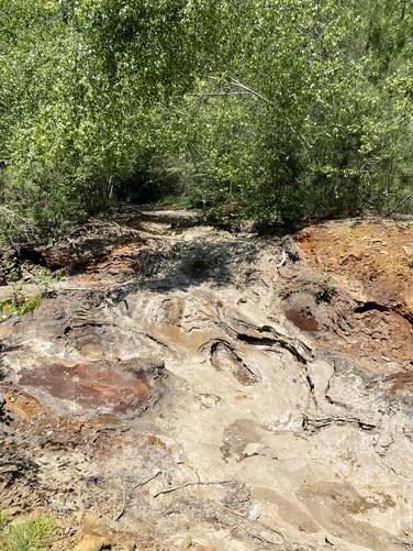
Just before reaching Rattler Road, hikers will cross Basswood Run around mile 3.2, but they may notice the creek bed looks rusty. This is because it is rusty. The rust is a byproduct of the iron sulfides in the rock reacting with rainwater, which produces sulfuric acid, thus causing this rust to appear.
After reaching Rattler Road, hikers will head the road to reach the parking lot to complete this 4-mile loop hike.
Anna S. Mine History, Ghost Stories, and Water Restoration
Understanding a bit of the history of the area may clear up a lot of questions about what hikers will find along this trail. First, the Anna S. Mine was in operation from 1905 - 1937 and was built by the Fall Brook Coal Company. The mine used the bucket tram to move coal across the Wilson Creek valley below and over to the mountains on the east side of the valley. Once the coal was on the eastern side of Wilson Creek valley, it would be transported by the New York Central railroad in Antrim, PA. Folklore claims that some miners would ride the buckets across the valley. One story claims that one miner road the buckets during the winter, but the tram was turned off and the miner froze to death hanging hundreds of feet above the mountain valley. Most of these stories were never proven or were disputed to not be plausible, but are still interesting to think about. Other stories depict miners who perished in the Anna S. Mine. More recently, in 2019, a haunting was reported by Susquehanna Life magazine at the Anna S. Mine. The story claims that while on a college geology class trip, people either heard human cries in the mine. On a returning trip to the Anna S. Mine, one of the people on the class trip brought a friend -- they claim at one point their car felt like it lost control as it slammed on the brakes and swerved for no apparent reason. Later they claim to hear voices and that their compass, which worked normally, was completely useless and broken near the Anna S. Mine. Another ghost story tells the tale of strip miners 1979 who were cutting into coal seams where the old Anna S. Mine shafts were located. The men stopped everything and left the work site in a hurry once they saw movement in the old shaft along with two ghost miners climbing out of the shaft with their lamps and pickaxes. Whether there are ghosts here or not, this unique piece of history is well worth the exploration.
The last bit of history hikers can note is the Babb Creek watershed restoration project, which more information can be found here. In short, this watershed restoration project spent a lot of time and money to alleviate mining runoff that sends heavy metals and water with improper pH downstream -- killing off fish and wildlife. The large open fields on the western side of this hike were cut down to build water reservoirs which help sustain a healthy and proper pH level for the mining runoff that continues to leak out of the mountain.
Most of this history is paraphrased and based on sources compiled by Mid State Trail Association Vice President, Peter Fleszar.
Parking
Hikers can find a small parking turnout near the coordinates provided on the north side of Rattler Road in Morris, PA. The parking lot is large enough to fit a few vehicles.
Pets
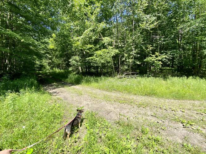
Dogs are allowed if leashed.
Blaze Colors
This trail follows orange blazes for only the Mid State Trail section of the hike. After leaving the Haunted Vista, the trail does not follow any blazes or markers at all, which can be a bit confusing. Having an offline map and/or downloading this track (with a Supporter Account) will keep hikers from getting lost.
Warning
Hikers must be careful while traversing the large boulders near the Rock Bypass as most of the rock crevasses are at least 5-feet deep, if not more, making it easy to trip and fall. Dog owners must also be careful if they bring their dogs along for this hike. Also note that this vista is the perfect place for snakes, like the Timber Rattler, to hang out and sunbathe.
Camping and Backpacking
Backpackers will find several places they can setup a tent along this trail, but must follow the state forest rules and regulations for backcountry / primitive /dispersed camping. Also note that campers or even day hikers should not light fires at the Haunted Vista since fires here could continue to burn through the ground to ignite coal underground, which would burn for decades like in Centralia, Pennsylvania.
The Haunted Vista is an old mining tailing (mining spoils) dump along the mountainside that features panoramic views of the mountains in Antrim, PA and the Wilson Creek valley. The hike also includes a rock crevasse traverse, an old mine named the "Anna S. Mine", an old mine runoff creek (treated with chemicals to correct the water's pH), and an open area with views along a service road.
Alternative Routes
Please see our other guides for reaching the Haunted Vista through via different routes: Haunted Vista via Haunted Mine Trail or the Haunted Vista via Anna S Road.
Trail Description
This hike begins along Rattler Road in Morris, PA and follows the Mid State Trail, heading north, toward the Haunted Vista. The first section of the trail is fairly boring compared to the rest of the hike -- hikers will meander their way through the forest, passing some short rock ledges, before the trail heads downhill into a ravine. This ravine follows Basswood Run creek and features a water source for filtering water or refilling your bottle on the south side just before the creek crossing (heading north). It also features a campsite on the north side of Basswood Run.
Continuing onward from Basswood Run, hikers will hike up what appears to be an old log slide. The trail will take a right-hand turn - so be on the lookout for orange blazes and a turn along the trail since it can be easy to miss this turn.
Not long after the hiker leaves the old log slide, the trail will reach a yellow blazed sign labled "Rock Bypass" -- this trail leaves the Mid State Trail and meanders through the rock ledges on the mountainside. This hike skips the yellow blazed Rock Bypass Trail and continues following the Mid State Trail. Hikers must be careful here as most of the rock crevasses are at least 5-feet deep, if not more, making it easy to trip and fall. Dog owners must also be careful if they bring their dogs along for this hike.
Immediately after reaching the opposite end of the Rock Bypass, hikers will reach another creek crossing -- but this time, the water flows a blue-ish white color. The white-colored water is a reminder that some miners did die hundreds of feet underground here while working the Anna S. Mine; however, this white water is due to a water treatment process to correct the mine water runoff's pH levels to where fish and other creatures can live in the water.
Just after crossing the ghost water creek, hikers will find some large mining slag dumped alongside the trail. Shortly after that, the trail will open up slightly with less trees as it heads uphill for about 100-feet. Near the top of this hill is the old Anna S. Bucket Tram. This bucket tram used to haul coal and other materials from the western mountain tops, across the Wilson Creek valley and over to the eastern mountain tops where it would be transported by the New York Central railroad in Antrim, PA.
Reaching the Haunted Vista
Finally, hikers will reach the Haunted Vista just beyond the old Anna S. Bucket Tram building. This vista point is an odd, but stunning spot to take in views of the Wilson Creek valley and the mountains in Antrim, Pennsylvania. During the Summer, this vista is intensely hot because of the old mining tailings (mining spoils) soaking up the sunlight, so hiking this during the cooler months is recommended. Also note that, with a keen eye, you can spot this vista from PA Route 287 below.
Hiking out from the Haunted Vista
Last, the hiker needs to find their way back to parking. This track follows a forest service road instead of taking the Mid State Trail back. This way back is a bit confusing so understanding the turns is critical to not getting lost.
From the Haunted Vista, hikers will want to head back south toward the Anna S. Bucket Tram building - instead of heading directly to the building, hike up the hill on the right-hand side of this fork in the trail. The trail will lead up to some concrete structures. From here, continue hiking uphill until you reach another junction -- at this junction, take a left-hand turn to head south.
The trail will continue heading south until it reaches yet another junction -- this trail junction has views and open fields to the left-hand side (which can be distracting) as it meets at a triangular intersection. Hikers can take in the views, by hiking left, before hiking back to this junction and heading south -- alternatively, skip the views and just take a right-hand turn here. Note that if you see a series of boulders lined in a row within a large open field, you have gone the wrong way and should turn back to the last trail junction.
Finally, after taking the proper turn at the last trail junction, hikers will head straight south until they finally reach Rattler Road once again.
Rusty Creek Bed at Basswood Run
Just before reaching Rattler Road, hikers will cross Basswood Run around mile 3.2, but they may notice the creek bed looks rusty. This is because it is rusty. The rust is a byproduct of the iron sulfides in the rock reacting with rainwater, which produces sulfuric acid, thus causing this rust to appear.
After reaching Rattler Road, hikers will head the road to reach the parking lot to complete this 4-mile loop hike.
Anna S. Mine History, Ghost Stories, and Water Restoration
Understanding a bit of the history of the area may clear up a lot of questions about what hikers will find along this trail. First, the Anna S. Mine was in operation from 1905 - 1937 and was built by the Fall Brook Coal Company. The mine used the bucket tram to move coal across the Wilson Creek valley below and over to the mountains on the east side of the valley. Once the coal was on the eastern side of Wilson Creek valley, it would be transported by the New York Central railroad in Antrim, PA. Folklore claims that some miners would ride the buckets across the valley. One story claims that one miner road the buckets during the winter, but the tram was turned off and the miner froze to death hanging hundreds of feet above the mountain valley. Most of these stories were never proven or were disputed to not be plausible, but are still interesting to think about. Other stories depict miners who perished in the Anna S. Mine. More recently, in 2019, a haunting was reported by Susquehanna Life magazine at the Anna S. Mine. The story claims that while on a college geology class trip, people either heard human cries in the mine. On a returning trip to the Anna S. Mine, one of the people on the class trip brought a friend -- they claim at one point their car felt like it lost control as it slammed on the brakes and swerved for no apparent reason. Later they claim to hear voices and that their compass, which worked normally, was completely useless and broken near the Anna S. Mine. Another ghost story tells the tale of strip miners 1979 who were cutting into coal seams where the old Anna S. Mine shafts were located. The men stopped everything and left the work site in a hurry once they saw movement in the old shaft along with two ghost miners climbing out of the shaft with their lamps and pickaxes. Whether there are ghosts here or not, this unique piece of history is well worth the exploration.
The last bit of history hikers can note is the Babb Creek watershed restoration project, which more information can be found here. In short, this watershed restoration project spent a lot of time and money to alleviate mining runoff that sends heavy metals and water with improper pH downstream -- killing off fish and wildlife. The large open fields on the western side of this hike were cut down to build water reservoirs which help sustain a healthy and proper pH level for the mining runoff that continues to leak out of the mountain.
Most of this history is paraphrased and based on sources compiled by Mid State Trail Association Vice President, Peter Fleszar.
Parking
Hikers can find a small parking turnout near the coordinates provided on the north side of Rattler Road in Morris, PA. The parking lot is large enough to fit a few vehicles.
Pets
Dogs are allowed if leashed.
Blaze Colors
This trail follows orange blazes for only the Mid State Trail section of the hike. After leaving the Haunted Vista, the trail does not follow any blazes or markers at all, which can be a bit confusing. Having an offline map and/or downloading this track (with a Supporter Account) will keep hikers from getting lost.
Warning
Hikers must be careful while traversing the large boulders near the Rock Bypass as most of the rock crevasses are at least 5-feet deep, if not more, making it easy to trip and fall. Dog owners must also be careful if they bring their dogs along for this hike. Also note that this vista is the perfect place for snakes, like the Timber Rattler, to hang out and sunbathe.
Camping and Backpacking
Backpackers will find several places they can setup a tent along this trail, but must follow the state forest rules and regulations for backcountry / primitive /dispersed camping. Also note that campers or even day hikers should not light fires at the Haunted Vista since fires here could continue to burn through the ground to ignite coal underground, which would burn for decades like in Centralia, Pennsylvania.