Haunted Vista via Haunted Mine Trail at Tioga State Forest in Antrim, Pennsylvania is a difficult 1.8-mile out-and-back hike that features views from Haunted Vista and passes the upper cascades of Haunted Mine Falls.
Trails
This hike follows two named trails: Haunted Mine Trail (yellow blazes), Mid State Trail (orange blazes).
Hike Description
This hike begins at the large parking turnout located on the West side of PA-287, north of Morris, PA. Hikers will find the trailhead for the Haunted Mine Trail located in the middle of the parking lot, on the opposite side of the rock barrier. The Haunted Mine Trail follows yellow blazes and heads uphill to start the hike, passing an always-muddy / wetland spot before the hill. Note that the Haunted Mine Trail follows an old grade that was once used for mining operations, so the trail itself - in many places - is littered with small fist-sized rocks. These rocks make it pretty tough to hike on when there's no snow. Given some snowpack, it makes for easier hiking on over these rockier sections of trail.
Once at the top of the first hill, from the trailhead, the Haunted Mine Trail then runs along a mountain grade with very-little undulation until the trail drops a bit before its second climb up the mountain.
Second Ascent / Sounds of Haunted Mine Falls - Mile 0.3
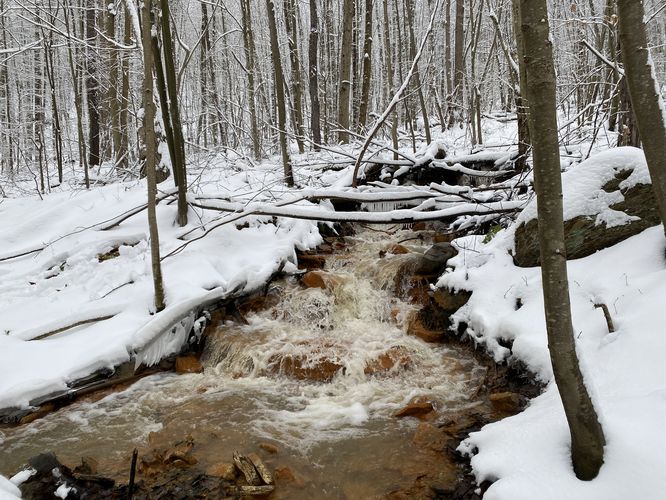
Around mile 0.3, the trail will start its second ascent up the mountain. Hikers will also find the rushing water sounds of Haunted Mine Falls as it cascades down the mountain side. The waterfall is likely Pennsylvania's tallest, however, is human-made and is a diversion flow from mine runoff that spits out of the long-abandoned Anna S Mine. This second mountain ascent is short but tough. The trail then takes a right-hand turn near the top of this pitch, where a sign labeled "view -->" can be found. The trail continues to ascend from here until it reaches the Haunted Mine Falls crossing.
Haunted Mine Falls Crossing - Mile 0.5
At mile 0.5, hikers will reach a creek crossing over a small section of Haunted Mine Falls. There's a nice ~4-foot cascade of this part of the upper reaches of Haunted Mine Falls, as best viewed from the North side of the trail. This creek crossing is shallow, but offers very-few places to cross. This was our 2nd time hiking this trail and Nina decided to not cross, letting me scratch my itch to complete this trail finally. The crossing wasn't horrible (in snowshoes), but I also had fully-waterproof boots on (Scarpa) which kept my feet dry. During Summer or warm months, that's not as much of an issue, but note that during the Winter, Haunted Mine Falls does not freeze over due to the warmer water temps within the old abandoned mine. Also, do not filter or drink this water, it's not potable.
3rd Ascent - Mile 0.6
After passing the Haunted Mine Falls crossing, hikers will head back downhill (a disappointment for sure) before hiking back up the mountain along a very-steep grade. This 3rd ascent starts around mile 0.6 and ends around mile 0.8, when the hiker reaches the Mid State Trail.
Mid State Trail / Right-hand Turn - Mile 0.8
Around mile 0.8, the hiker will leave the Haunted Mine Trail to reach the Mid State Trail. Take a right-hand turn here to head toward the Haunted Vista. Follow the orange blazes of the Mid State Trail as it heads northward.
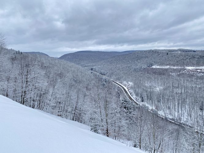
Haunted Vista - Mile 0.9
At mile 0.9, hikers will finally reach the Haunted Vista. Here, you get views northward toward Wellsboro and eastward of the mountain tops of Antrim, PA across the valley. This view is beautiful year-round -- during the Summer you can watch the fog lift from the valley, during Autumn you can take in the views with colorful foliage surrounding, Spring has wildflowers and bright new leaf growth on the mountain sides, and during this Winter hike I was able to enjoy the freezing wind rip by on top of the steep mine tailings slope with snow-covered trees.
Hiking Out - Mile 0.9 to 1.8
The hike out should be noted that the steep downhill sections are a bit of a pain. Trekking poles help tremendously here, so bring them if you have them. The creek crossing at Haunted Mine Falls is just as annoying as the hike in. If hiking during the Winter, watch the steep slopes with snowshoes as even with excellent tred/grip, you might slide due to the sheer elevation grade.
Parking
Hikers will find a very large parking turnout at the coordinates provided, located on PA-287 north of Morris, PA.
Pets
Dogs are allowed only if leashed and must be cleaned up after.
Difficulty
This hike should be considered moderate at the easiest; however, due to the steep ascents and undulating trail, I rated this hike as "hard". I personally pushed myself on this trail as I broke trail in the snow (only ~5-inches) with snowshoes, but the steep ascents were gnarly. I had no idea the trail would descent after the creek crossing, which was brutal mentally -- then the last final ascent was just horrible. Descending, I slid on steep grades with hardcore mountaineering snowshoes, so all things considered, the difficulty should be considered "hard" for most hikers.
Warnings
Timber Rattlesnake: This area is home to the Timber Rattlesnake which roams the forest floors from the end of April through early October each year. Be on the lookout for rattlers and give any you find plenty of space.
Rocky terrain: This trail follows some very rocky terrain, which can be difficult to hike on and easy to roll and ankle on.
Steep slopes: This trail ascends a few very steep slopes with a combination of rocky terrain. Watch your step and bring trekking poles to help with the elevation. Haunted Mine Vista especially has a very-steep slope -- stay on the flat ground when exploring the vista, especially during the Winter.
Trails
This hike follows two named trails: Haunted Mine Trail (yellow blazes), Mid State Trail (orange blazes).
Hike Description
This hike begins at the large parking turnout located on the West side of PA-287, north of Morris, PA. Hikers will find the trailhead for the Haunted Mine Trail located in the middle of the parking lot, on the opposite side of the rock barrier. The Haunted Mine Trail follows yellow blazes and heads uphill to start the hike, passing an always-muddy / wetland spot before the hill. Note that the Haunted Mine Trail follows an old grade that was once used for mining operations, so the trail itself - in many places - is littered with small fist-sized rocks. These rocks make it pretty tough to hike on when there's no snow. Given some snowpack, it makes for easier hiking on over these rockier sections of trail.
Once at the top of the first hill, from the trailhead, the Haunted Mine Trail then runs along a mountain grade with very-little undulation until the trail drops a bit before its second climb up the mountain.
Second Ascent / Sounds of Haunted Mine Falls - Mile 0.3
Around mile 0.3, the trail will start its second ascent up the mountain. Hikers will also find the rushing water sounds of Haunted Mine Falls as it cascades down the mountain side. The waterfall is likely Pennsylvania's tallest, however, is human-made and is a diversion flow from mine runoff that spits out of the long-abandoned Anna S Mine. This second mountain ascent is short but tough. The trail then takes a right-hand turn near the top of this pitch, where a sign labeled "view -->" can be found. The trail continues to ascend from here until it reaches the Haunted Mine Falls crossing.
Haunted Mine Falls Crossing - Mile 0.5
At mile 0.5, hikers will reach a creek crossing over a small section of Haunted Mine Falls. There's a nice ~4-foot cascade of this part of the upper reaches of Haunted Mine Falls, as best viewed from the North side of the trail. This creek crossing is shallow, but offers very-few places to cross. This was our 2nd time hiking this trail and Nina decided to not cross, letting me scratch my itch to complete this trail finally. The crossing wasn't horrible (in snowshoes), but I also had fully-waterproof boots on (Scarpa) which kept my feet dry. During Summer or warm months, that's not as much of an issue, but note that during the Winter, Haunted Mine Falls does not freeze over due to the warmer water temps within the old abandoned mine. Also, do not filter or drink this water, it's not potable.
3rd Ascent - Mile 0.6
After passing the Haunted Mine Falls crossing, hikers will head back downhill (a disappointment for sure) before hiking back up the mountain along a very-steep grade. This 3rd ascent starts around mile 0.6 and ends around mile 0.8, when the hiker reaches the Mid State Trail.
Mid State Trail / Right-hand Turn - Mile 0.8
Around mile 0.8, the hiker will leave the Haunted Mine Trail to reach the Mid State Trail. Take a right-hand turn here to head toward the Haunted Vista. Follow the orange blazes of the Mid State Trail as it heads northward.
Haunted Vista - Mile 0.9
At mile 0.9, hikers will finally reach the Haunted Vista. Here, you get views northward toward Wellsboro and eastward of the mountain tops of Antrim, PA across the valley. This view is beautiful year-round -- during the Summer you can watch the fog lift from the valley, during Autumn you can take in the views with colorful foliage surrounding, Spring has wildflowers and bright new leaf growth on the mountain sides, and during this Winter hike I was able to enjoy the freezing wind rip by on top of the steep mine tailings slope with snow-covered trees.
Hiking Out - Mile 0.9 to 1.8
The hike out should be noted that the steep downhill sections are a bit of a pain. Trekking poles help tremendously here, so bring them if you have them. The creek crossing at Haunted Mine Falls is just as annoying as the hike in. If hiking during the Winter, watch the steep slopes with snowshoes as even with excellent tred/grip, you might slide due to the sheer elevation grade.
Parking
Hikers will find a very large parking turnout at the coordinates provided, located on PA-287 north of Morris, PA.
Pets
Dogs are allowed only if leashed and must be cleaned up after.
Difficulty
This hike should be considered moderate at the easiest; however, due to the steep ascents and undulating trail, I rated this hike as "hard". I personally pushed myself on this trail as I broke trail in the snow (only ~5-inches) with snowshoes, but the steep ascents were gnarly. I had no idea the trail would descent after the creek crossing, which was brutal mentally -- then the last final ascent was just horrible. Descending, I slid on steep grades with hardcore mountaineering snowshoes, so all things considered, the difficulty should be considered "hard" for most hikers.
Warnings
Timber Rattlesnake: This area is home to the Timber Rattlesnake which roams the forest floors from the end of April through early October each year. Be on the lookout for rattlers and give any you find plenty of space.
Rocky terrain: This trail follows some very rocky terrain, which can be difficult to hike on and easy to roll and ankle on.
Steep slopes: This trail ascends a few very steep slopes with a combination of rocky terrain. Watch your step and bring trekking poles to help with the elevation. Haunted Mine Vista especially has a very-steep slope -- stay on the flat ground when exploring the vista, especially during the Winter.