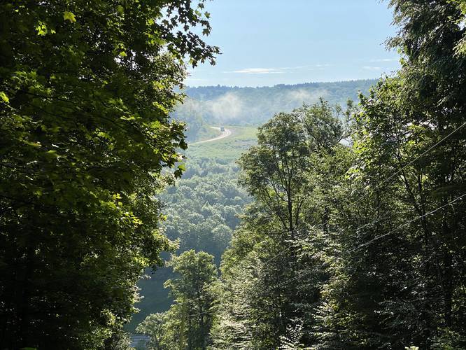
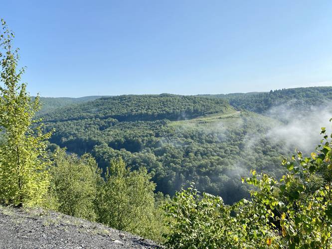
The Haunted Vista via Anna S Rd at Tioga State Forest in Antrim, Pennsylvania is a moderate 2-mile out-and-back hike that leads to a beautiful vista point above PA Route 287, the Haunted Vista.
Alternative Routes
To reach the Haunted Vista through a different route, check out our Haunted Vista via Mid State Trail hiking guide or our Haunted Vista via Haunted Mine Trail guide. The Haunted Vista via Mid State Trail hike is a longer 4-mile loop, but includes more scenery.
Trail Description
This hike follows the Mid State Trail (MST), that follows orange blazes, along the public road - Anna S Road - starting from the intersection of Anna S Road and PA Route 287.
The trail leads up Anna S Road until it reaches a hairpin turn. The ascent uphill is moderate for physically-fit hikers.
At the hairpin turn, hikers will head straight along private property (keeping-left near a yellow gate) and follows a service road that leads into Tioga State Forest.
Hikers will eventually reach another yellow gate and a sign that labels the Mid State Trail. From here, hikers will enter Tioga State Forest and will no longer be on private property.
Junction turn to the Vista
About 0.1-miles after the 2nd yellow gate, after entering Tioga State Forest, hikers will find a sign on their left-hand side labeled "Mid State Trail / View". Take this left-hand turn and hike down the narrow and rocky 10-foot tall rock bluff before reaching a geocache and eventually the Haunted Vista.
The hike back to parking follows the same route as the way up making this a moderate 2-mile out-and-back hike.
Parking
Hikers can find parking at a small turnout on the eastern side of PA Route 287, about 50-feet north of Anna S Road. This dirt turnout can hold about three vehicles. Important note: hikers may be tempted to park along Anna S Road near the hairpin turn, but since the land up there is all private property, there are no public parking locations. Respect the local residents and do not park along Anna S Road.
Private Property
A small section of this trail passes through private property -- please be respectful and stay on the trail at all times.
Pets
Dogs are allowed if leashed.
Geocache
There's a geocache located just before the Haunted Vista along the trail -- look for the wooden trail sign labeled "Haunted Vista / Anna S Mine".
Warnings
Rattlesnakes: The Haunted Vista is a good place for snakes to sunbathe, so hikers may come across a Timber Rattlesnake here from time to time.
No fires: Day hikers and backpackers should not light fires at the Haunted Vista since fires here could continue to burn through the ground to ignite coal underground, which would burn for decades like in Centralia, PA.
Anna S. Mine History, Ghost Stories, and Water Restoration
Understanding a bit of the history of the area may clear up a lot of questions about what hikers will find along this trail. First, the Anna S. Mine was in operation from 1905 - 1937 and was built by the Fall Brook Coal Company. The mine used a bucket tram near the vista point to move coal across the Wilson Creek valley below and over to the mountains on the east side of the valley. Once the coal was on the eastern side of Wilson Creek valley, it would be transported by the New York Central railroad in Antrim, PA. Folklore claims that some miners would ride the buckets across the valley. One story claims that one miner road the buckets during the winter, but the tram was turned off and the miner froze to death hanging hundreds of feet above the mountain valley. Most of these stories were never proven or were disputed to not be plausible, but are still interesting to think about. Other stories depict miners who perished in the Anna S. Mine. More recently, in 2019, a haunting was reported by Susquehanna Life magazine at the Anna S. Mine. The story claims that while on a college geology class trip, people either heard human cries in the mine. On a returning trip to the Anna S. Mine, one of the people on the class trip brought a friend -- they claim at one point their car felt like it lost control as it slammed on the brakes and swerved for no apparent reason. Later they claim to hear voices and that their compass, which worked normally, was completely useless and broken near the Anna S. Mine. Another ghost story tells the tale of strip miners 1979 who were cutting into coal seams where the old Anna S. Mine shafts were located. The men stopped everything and left the work site in a hurry once they saw movement in the old shaft along with two ghost miners climbing out of the shaft with their lamps and pickaxes. Whether there are ghosts here or not, this unique piece of history is well worth the exploration.
The last bit of history hikers can note is the Babb Creek watershed restoration project, which more information can be found here. In short, this watershed restoration project spent a lot of time and money to alleviate mining runoff that sends heavy metals and water with improper pH downstream -- killing off fish and wildlife. Reservoirs were built nearby which help sustain a healthy and proper pH level for the mining runoff that continues to leak out of the mountain.
Most of this history is paraphrased and based on sources compiled by Mid State Trail Association Vice President, Peter Fleszar.